Cheap LiDAR for Drone: How to Choose a Lightweight Budget Sensor for UAV Obstacle Avoidance & Mapping
When engineers search for a cheap LiDAR for drone, they are usually trying to solve a very real shop-floor problem: how do you give a UAV reliable distance sensing or 3D perception without hanging a heavy, expensive airborne mapping payload under it? Here’s the deal: on a small drone, every gram shows up in flight time, motor load, stability, and battery margin. A bulky mechanical LiDAR might offer longer range or denser point clouds, but it can also cut endurance, complicate mounting, and drive up system cost fast. That is why lightweight solid-state dToF LiDAR modules are getting a lot of attention for UAV obstacle avoidance, altitude hold, terrain following, inspection drones, robotics development, and embedded perception work.
Look, “cheap” should never mean “throwaway.” A budget LiDAR sensor still has to deliver repeatable ranging, useful outdoor performance, a stable frame rate, enough field of view, low power draw, and interfaces your team can actually work with. In this guide, we’ll break down how to choose a low-cost drone LiDAR, which specifications matter, where affordable modules do a good job, and where you still need a professional survey-grade system. We’ll also look at the DTOF Solid State LiDAR HM-LD1, a compact 28g dToF LiDAR module with 3D depth output, 60° × 45° FOV, UART/UDP/UVC interfaces, and indoor/outdoor ranging capability suited for UAV perception and embedded development.
Table of Contents
- 👉 Quick Answer: What Is the Best Cheap LiDAR for Drone Use?
- 👉 What “Cheap LiDAR for Drone” Really Means
- 👉 Common UAV Use Cases for Budget LiDAR
- 👉 LiDAR Technologies Explained: dToF, iToF, Solid-State, and Mechanical Scanning
- 👉 Key Specs to Compare Before Buying a Drone LiDAR
- 👉 Weight, Power, and Integration Requirements for UAVs
- 👉 Using Cheap LiDAR for Drone Obstacle Avoidance
- 👉 Can Cheap Drone LiDAR Be Used for Mapping?
- 👉 Recommended Budget Module: DTOF Solid State LiDAR HM-LD1
- 👉 Buying Checklist: How to Evaluate a Low-Cost UAV LiDAR
- 👉 Typical UAV Integration Workflow
- 👉 Industrial Applications for Lightweight Drone LiDAR
- 👉 Common Mistakes When Choosing Cheap Drone LiDAR
- 👉 Final Recommendation: How to Choose the Right Cheap LiDAR for Drone Projects
- 👉 FAQ: Cheap LiDAR for Drone
Quick Answer: What Is the Best Cheap LiDAR for Drone Use?
For most small UAV projects, the best cheap LiDAR for drone integration is a compact solid-state dToF module, not a heavy mechanical scanning unit. A module such as the DTOF Solid State LiDAR HM-LD1 makes sense when the job calls for lightweight depth sensing, obstacle detection, terrain awareness, or embedded vision development. With a weight of only 28g, 1.2W power consumption, 60° × 45° FOV, 40 × 30 resolution, and UART/UDP/UVC interfaces, it fits many UAV perception systems where size, weight, power, and cost matter more than survey-grade point density.
A low-cost LiDAR for drone use is usually best for UAV obstacle avoidance, altitude hold, terrain following, short-range 3D perception, indoor navigation, low-altitude inspection, and R&D prototyping. It is usually not the right tool for professional corridor mapping, dense vegetation penetration, high-altitude topographic survey, or long-range multi-return airborne LiDAR deliverables. In the shop, we would put it this way: a slow indoor inspection drone and a survey UAV collecting georeferenced terrain data are two different animals. Don’t spec them like they are the same machine.
For UAV navigation systems that combine LiDAR with GNSS positioning, see our guide on what RTK is and how centimeter-level GPS navigation works.
Looking for a lightweight dToF LiDAR module for UAV obstacle avoidance? View the HM-LD1 LiDAR specifications.
What “Cheap LiDAR for Drone” Really Means
In industrial engineering, the word “cheap” needs a little discipline. A cheap LiDAR for drone projects should not mean a random low-quality sensor with weak documentation, unstable readings, and no integration support. It should mean budget-conscious, lightweight, application-appropriate, and developer-friendly. The cheapest component on a purchase order can become the most expensive part of the system if it burns weeks of engineering time.
Cheap Does Not Mean Survey-Grade
Professional airborne LiDAR mapping payloads can cost thousands to tens of thousands of dollars. These systems may include high-frequency laser scanners, GNSS/INS integration, multi-return capability, high point density, calibrated survey workflows, precise timestamping, and advanced processing software. They are built to produce geospatial deliverables such as point clouds, terrain models, corridor maps, and engineering-grade survey outputs.
Budget LiDAR modules are different. They are normally designed for perception, robotics, obstacle avoidance, short-range ranging, and embedded sensing. A perception LiDAR can be extremely useful on a drone, but it should not be sold or treated as a direct replacement for a survey payload. The real question is not “Is this LiDAR cheap?” The real question is, “Does this LiDAR give the right data, at the right range, with the right weight and power, for this UAV mission?”
What Price-Conscious UAV Teams Should Prioritize
UAV teams looking for an affordable drone LiDAR should prioritize practical engineering fit over headline specs. In the shop, the winning sensor is the one that mounts cleanly, powers reliably, streams data without drama, and behaves predictably during flight tests.
- ✅ Low sensor weight so flight time does not get punished
- ✅ Stable short-range performance instead of inflated maximum range claims
- ✅ Simple electrical integration with a clean power budget
- ✅ Usable outdoor detection under realistic sunlight
- ✅ Embedded platform compatibility for onboard processing
- ✅ SDK availability and documentation your developers can actually use
- ✅ Vendor technical support when the first field test gets messy
- ✅ Mechanical mounting simplicity, especially on small airframes
A 28g module with 1.2W power consumption is often easier to deploy on a small UAV than a heavier scanning sensor, even if the heavier unit offers more range or more points. That is not a compromise; it is proper system engineering.
Budget LiDAR vs Low-Quality LiDAR
A low-cost sensor can still be industrially useful if it provides repeatable performance. Repeatability is critical because obstacle avoidance algorithms depend on stable data, not just impressive maximum range. A budget LiDAR that consistently detects objects within its intended range may be more valuable than a poorly documented long-range unit with noisy output. Technical fit matters more than price alone.
Common UAV Use Cases for Budget LiDAR
Budget LiDAR works best when the drone mission is clearly defined. It can support real-time decisions, provide direct distance measurements, and add spatial awareness that cameras or barometers alone may not provide. Below are the most common UAV use cases where an affordable solid-state LiDAR makes engineering sense.
Obstacle Avoidance
Obstacle avoidance is one of the strongest use cases for a cheap LiDAR for drone development. A UAV must detect nearby objects in its path, estimate whether those objects are a collision risk, and react quickly enough to slow down, stop, or reroute. Budget LiDAR can support this process for indoor drones, warehouse drones, inspection UAVs, low-speed autonomous platforms, research drones, and agricultural drones flying near terrain or vegetation.
Important metrics include field of view, minimum detection range, frame rate, latency, outdoor sunlight tolerance, and detection reliability on different surfaces. A 3D depth map gives more context than a single range point because it can identify whether an object is left, right, centered, high, or low in the sensor’s view.
Altitude Hold and Terrain Following
A downward-facing LiDAR can help estimate height above ground. Compared with a barometer, which estimates altitude from air pressure, LiDAR directly measures the distance to the surface below. This is valuable when flying close to the ground, moving over uneven terrain, or operating inside buildings where GNSS may be unavailable or unreliable.
LiDAR altitude sensing can also be combined with RTK positioning for broader navigation accuracy. For positioning accuracy beyond onboard ranging, read What Is RTK? The Centimeter-Level GPS Navigation Guide.
Indoor Navigation and SLAM Assistance
Indoor drones cannot rely on satellite navigation, so they need onboard perception. Budget LiDAR can support indoor perception, but depending on sensor resolution and field of view, it may need to be fused with IMU data, visual odometry, optical flow, barometers, ultrasonic sensors, or other range sensors. For sensor fusion fundamentals, see How to Master Robot State Estimation.
In SLAM applications, a perception-grade LiDAR can help create local obstacle maps or support short-range environmental understanding. It may not produce the same density as a professional mapping scanner, but it can provide useful real-time spatial information for navigation and avoidance.
Inspection and Distance Measurement
Short-range LiDAR can support inspection missions involving bridges, expressways, dams, power facilities, warehouses, tanks, and industrial structures. In these applications, the drone may need to maintain a safe standoff distance from surfaces while moving slowly along an inspection path. A lightweight depth sensor can help prevent the drone from drifting too close to a wall, beam, cable tray, pipe rack, or other structure.
Basic 3D Perception and Depth Imaging
Depth-map LiDAR provides structured environmental information instead of a single distance value. It can help detect walls, objects, height changes, and collision risks. To understand how depth images become 3D perception data, read dToF LiDAR Imagery Explained: Depth Maps.
LiDAR Technologies Explained: dToF, iToF, Solid-State, and Mechanical Scanning
Choosing the right affordable drone LiDAR requires understanding the basic sensor architectures. Different LiDAR technologies have different tradeoffs in range, cost, size, resolution, sunlight tolerance, and mechanical complexity. You do not need to become an optics PhD to make a good selection, but you do need to know what each architecture is good at.
Direct Time-of-Flight LiDAR
Direct Time-of-Flight, or dToF, measures distance by timing the round trip of emitted light pulses. Because light travels at a known speed, the sensor can calculate distance based on the measured time delay. In compact solid-state LiDAR modules, SPAD detectors are often used to detect very small numbers of photons, enabling depth measurement in a small package.
dToF is attractive for drone ranging because it directly measures time delay and can support accurate depth output. The HM-LD1 uses solid-state dToF LiDAR based on SPAD technology, making it relevant for lightweight UAV perception and robotics development.
Indirect Time-of-Flight LiDAR
Indirect Time-of-Flight, or iToF, typically uses the phase shift between emitted and received modulated light to estimate distance. iToF systems can be compact and are commonly used in depth cameras, gesture recognition, and embedded perception. Depending on the design, they may be sensitive to ambient light, multipath effects, and certain reflective surfaces. iToF can be a good solution in many applications, but drone developers should validate outdoor performance carefully.
Solid-State LiDAR
Solid-state LiDAR is highly attractive for small drones because it avoids large rotating mechanical assemblies. That can reduce weight, improve durability under vibration, simplify mounting, and reduce power consumption. For UAV obstacle avoidance and depth imaging, compact solid-state modules are often easier to integrate than mechanical scanners.
Mechanical Scanning LiDAR
Mechanical scanning LiDAR systems use rotating assemblies, spinning mirrors, or other moving optical components to scan the environment. They can provide wide coverage, higher point density, and longer range depending on the model. However, they are often heavier, more expensive, and more mechanically complex. For mapping or advanced robotics navigation, they may be appropriate, but for small UAV perception, a lightweight solid-state module may be the more practical choice.
For examples of established industrial LiDAR and positioning ecosystems, readers can also compare solutions from CHC Navigation and sensor manufacturers such as HOKUYO.
Key Specs to Compare Before Buying a Drone LiDAR
A cheap LiDAR for drone use should be evaluated by engineering specifications, not by price alone. The following parameters determine whether a sensor can support your flight mission, control architecture, and integration workflow.
Weight
Weight is one of the most important specifications for UAV integration. Every gram added to the drone affects flight time, battery consumption, payload capacity, stability, motor load, thermal behavior, and mechanical mounting design. For small drones, sensors under 50g are much easier to integrate than heavier scanning systems. The HM-LD1 weighs 28g, making it suitable for projects where payload mass is tightly constrained.
Power Consumption
Power affects battery life and thermal design. A 1.2W module is significantly easier to integrate than higher-power sensors that require dedicated power regulation and heat management. Drone developers should consider current draw, voltage regulation, total electronics power budget, battery impact, heat dissipation, and EMI concerns from motor systems.
Ranging Capability
A drone LiDAR’s range must match the application. Slow indoor drones may only need several meters of reliable detection. Outdoor obstacle avoidance may require more range depending on flight speed and stopping distance. Many optical sensors perform better indoors or at night than in bright sunlight. Surface reflectivity also matters; dark, glass, shiny, or thin objects may be more difficult to detect.
Ranging Accuracy
Accuracy describes how close a measurement is to the true distance. Precision describes repeatability. Resolution describes the smallest spatial or numerical detail the system can output. Repeatability describes whether the sensor behaves consistently over time. For obstacle avoidance, ±3cm accuracy can be very useful. For survey-grade mapping, centimeter-level ranging accuracy alone is not enough because georeferencing, calibration, GNSS/INS synchronization, scan geometry, and point density also matter.
Field of View
Field of view determines how much of the scene the sensor can see. A narrow FOV may be suitable for focused distance measurement, while a wider FOV provides better obstacle awareness. A downward-facing FOV supports altitude hold and terrain following. A forward-facing FOV supports collision avoidance. A 60° horizontal × 45° vertical FOV is useful for compact 3D perception because it gives the UAV a meaningful scene area rather than a single line or point.
Resolution
A 40 × 30 depth resolution means the sensor outputs a depth grid of 1,200 measurement points per frame. This is not equivalent to high-density survey LiDAR, but it is useful for object presence detection, obstacle zones, and depth-map perception. A drone can divide the depth frame into left, center, right, top, and bottom regions to make practical control decisions.
Frame Rate
Frame rate determines how frequently the scene is updated. At 10fps, the sensor updates ten times per second. The acceptable frame rate depends on drone speed, control-loop requirements, processing latency, obstacle density, and safety margin. For low-speed UAVs and embedded perception prototypes, 10fps can be practical, but high-speed autonomous flight may require longer range, faster update rates, or additional sensors.
Interface Options
Interfaces matter because they determine how easily the LiDAR connects to the rest of the UAV system. UART is useful for microcontrollers, flight controller companion systems, and simple data channels. UDP is practical for network-based embedded systems. UVC can support PC, Linux, and camera-like depth streaming workflows. Interface flexibility reduces development friction.
SDK and Platform Support
A sensor is easier to use if SDKs are available for the platforms your team already uses. HM-LD1 support includes x86 Windows, x86 Linux, and ARM Linux SDK options, which is helpful for development across PCs, Raspberry Pi-class systems, embedded Linux boards, and onboard companion computers.
Weight, Power, and Integration Requirements for UAVs
UAVs impose stricter integration constraints than many ground robots. A ground robot can often carry heavier electronics or a larger battery. A drone must lift every component continuously, so payload decisions affect flight time and safety immediately.
Why Lightweight LiDAR Matters
Even if a drone can lift a sensor, added weight may reduce battery life and limit mission duration. A cheap LiDAR is not truly practical if it requires a larger drone, extra batteries, or complex vibration isolation. Lightweight LiDAR modules are especially valuable for small quadcopters, indoor UAVs, experimental drones, and platforms where the sensor must be mounted far from the center of gravity.
How to Estimate Power Budget
If a LiDAR consumes 1.2W and the UAV battery is 4S 5000mAh, the battery energy is approximately 14.8V × 5Ah, or 74Wh. The LiDAR energy draw for 30 minutes is approximately 1.2W × 0.5h, or 0.6Wh. That is small compared with propulsion energy, but it still matters for regulated electronics power rails. A stable supply is essential because brownouts, voltage ripple, or electrical noise can cause data dropouts.
Mounting Location
A forward-facing LiDAR supports obstacle avoidance. A downward-facing LiDAR supports altitude hold and terrain following. An angled front-down installation can help detect both ground changes and forward obstacles. Side-facing modules can support wall following or inspection standoff control. Multi-module configurations may be used when wider coverage is required, but they increase cost, power, data processing, and mounting complexity.
Vibration and Environmental Protection
Drones experience vibration, airflow, dust, moisture, and sunlight. LiDAR mounting should avoid propeller obstruction, direct reflections from landing gear, loose vibration-prone brackets, lens contamination, and glare where possible. Developers should also validate that the sensor’s optical window remains clean and that the mounting orientation does not create false returns from the drone frame.
Using Cheap LiDAR for Drone Obstacle Avoidance
Obstacle avoidance is not simply distance measurement. A UAV must detect obstacles, classify risk, estimate available maneuver space, and react safely. A cheap LiDAR for drone obstacle avoidance can be extremely valuable when integrated with realistic assumptions about range, speed, and environment.
What the Sensor Must Detect
A drone may need to detect walls, poles, wires, trees, ground, ceilings, people, vehicles, structural beams, indoor shelving, and uneven terrain. Budget LiDAR may detect many solid surfaces well, but thin wires, glass, highly absorbent materials, or complex reflective surfaces can remain challenging. This is why LiDAR should be part of a broader perception system rather than the only safety mechanism.
Detection Distance vs Drone Speed
A UAV moving at 2m/s with 8m of practical outdoor detection range has roughly four seconds of maximum warning under ideal conditions. The usable response time is shorter after accounting for processing latency, confidence filtering, control command generation, and safe maneuvering. Faster drones require longer detection range, wider situational awareness, or additional sensing modalities.
Depth Map Zones
For a 40 × 30 depth map, obstacle avoidance software can divide the image into zones such as left, center, right, top, bottom, near field, and far field. This enables practical decision logic without requiring dense 3D reconstruction. For example, if the center zone contains an object within the safety distance, the system can slow down or command a lateral avoidance maneuver.
Sensor Fusion
LiDAR should be combined with IMU data, optical flow, GNSS/RTK, barometers, cameras, radar where needed, and flight controller state data. Fusion improves stability because each sensor has strengths and weaknesses. For a deeper explanation of how multiple sensors are fused into stable robot navigation, read How to Master Robot State Estimation.
Can Cheap Drone LiDAR Be Used for Mapping?
Budget drone LiDAR can support some mapping tasks, but it is important to define mapping correctly. There is a major difference between creating a local obstacle map for navigation and producing a professional georeferenced survey deliverable.
Basic Mapping vs Professional Survey Mapping
Budget LiDAR can support local obstacle maps, indoor occupancy maps, short-range 3D scene reconstruction, experimental SLAM, robot perception datasets, inspection distance logging, and object boundary estimation. Professional survey mapping usually requires high point density, high scan rate, GNSS/INS integration, precise timestamping, calibration, multi-return support, high-altitude range, and mapping software workflow.
Why Point Density Matters
A 40 × 30 depth frame gives 1,200 points per frame. At 10fps, that is up to 12,000 depth samples per second before filtering and valid-return limitations. This is useful for perception but far below many professional LiDAR mapping systems. Point density affects how much detail can be reconstructed, how small objects appear in the data, and how useful the point cloud is for measurement or survey deliverables.
When Budget LiDAR Is Still Useful for Mapping
Affordable drone LiDAR is still useful for indoor robotics maps, low-speed experimental UAV SLAM, obstacle boundary estimation, volume approximation, zone intrusion monitoring, and small-scale research environments. It is also useful for teams learning depth perception before investing in high-end airborne mapping systems.
When to Choose a Survey-Grade Payload Instead
Choose a professional survey-grade payload when the mission requires topographic survey deliverables, forestry canopy penetration, powerline corridor mapping, engineering-grade terrain models, georeferenced point clouds, or high-speed flight mapping. For professional positioning and mapping ecosystems, users may compare technologies from CHC Navigation.
Recommended Budget Module: DTOF Solid State LiDAR HM-LD1
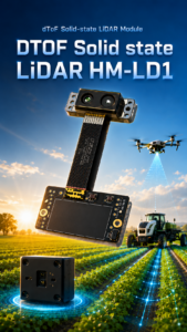
The DTOF Solid State LiDAR HM-LD1 is a compact SPAD dToF LiDAR module designed for real-time depth imaging and 3D point cloud output. For drone developers looking for a cheap LiDAR for drone obstacle avoidance or short-range perception, its major advantages are low weight, low power consumption, wide field of view, and multiple interface options. It is especially suitable for small UAVs, autonomous mobile robots, smart inspection systems, and embedded vision development.
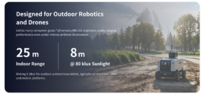
The HM-LD1 supports indoor ranging from 0.5m to 25m and outdoor ranging from 0.2m to 8m. Its ranging accuracy is ±3cm, and the 60° × 45° FOV gives a practical view for depth-map perception. With UART, UDP, and UVC interfaces, it can be integrated into PCs, Raspberry Pi-style systems, flight controller companion computers, and embedded platforms. MRP also offers SDK support for x86 Windows, x86 Linux, and ARM Linux, which helps reduce development friction.
| Specification | DTOF Solid State LiDAR HM-LD1 |
|---|---|
| Product Name | DTOF Solid State LiDAR HM-LD1 |
| Technology | Solid-state dToF LiDAR based on SPAD technology |
| Dimension | 43.5mm × 30mm × 26.5mm |
| Weight | 28g |
| Indoor Ranging Capability | 0.5m–25m |
| Outdoor Ranging Capability | 0.2m–8m |
| Ranging Accuracy | ±3cm |
| Field of View | 60° horizontal × 45° vertical |
| Resolution | 40 × 30 |
| Frame Rate | 10fps |
| Interface | UART / UDP / UVC |
| Operating Temperature | -20℃ to 60℃ |
| Power Consumption | 1.2W |
| Supported Development Platforms | x86 Windows, x86 Linux, ARM Linux SDK support |
| Typical Applications | UAV obstacle avoidance, altitude hold, terrain following, robot navigation, SLAM assistance, distance detection, smart inspection, depth imaging, object recognition, volume measurement, user presence detection, autofocus, and zone intrusion monitoring |
| Product URL | https://myrobotproject.com/product/dtof-solid-state-lidar-hm-ld1/ |
| Brochure | Download DTOF SSL HM-LD1 Product Brochure |
Note: The formal specification table lists the HM-LD1 dimension as 43.5mm × 30mm × 26.5mm. If mechanical drawings or product text vary, use the confirmed manufacturer drawing for final mounting design.
View Product Details & Pricing ➔
Buying Checklist: How to Evaluate a Low-Cost UAV LiDAR
Before buying any low-cost drone LiDAR, slow down and work through the basic engineering questions. This is where a lot of teams save themselves from buying the wrong sensor twice.
Step 1 — Define the Mission
Start by defining the mission. Is the LiDAR for obstacle avoidance, mapping, altitude hold, indoor navigation, inspection distance control, or terrain following? What flight speed is expected? What detection range is required? A cheap LiDAR for drone obstacle avoidance may be ideal for one project and unsuitable for another if the range, FOV, or data output does not match the control strategy.
Step 2 — Check Weight and Power
For small drones, prioritize sensors under 50g where possible, low wattage, stable voltage compatibility, and minimal thermal load. Weight affects flight time immediately, while power affects regulated electronics design. The HM-LD1’s 28g weight and 1.2W consumption are strong values for compact UAV and robotics platforms.
Step 3 — Compare Indoor and Outdoor Range Separately
Outdoor performance is often lower due to sunlight and surface reflectivity. Always check outdoor range, not only maximum indoor range. A sensor that reaches 25m indoors but 8m outdoors can still be highly useful, but the flight envelope must be designed around outdoor limits.
Step 4 — Evaluate FOV and Resolution Together
A wide FOV with extremely low resolution may not detect small objects reliably. A narrow FOV with good resolution may miss obstacles outside the center of the view. Balance both parameters. For many compact perception tasks, 60° × 45° FOV with 40 × 30 depth output provides a useful combination of scene coverage and zone-based obstacle detection.
Step 5 — Confirm Interfaces and SDKs
A cheap LiDAR is not cheap if integration takes months. Confirm UART support, UDP output, UVC compatibility, SDK availability, Linux support, ARM support, and documentation quality. Interface flexibility lets teams begin testing on a PC and later move to an embedded onboard computer.
Step 6 — Test on Real Surfaces
Before field deployment, test the LiDAR on white walls, dark objects, concrete, metal, vegetation, glass, moving people, and sunlit surfaces. Real-world testing is especially important for UAV applications because the sensor will experience motion, vibration, changing light, and changing angles of incidence.
Typical UAV Integration Workflow
A practical integration workflow reduces risk. Even a small LiDAR module should be treated as a flight-critical perception component if it influences navigation or avoidance behavior. Good teams do not bolt it on Friday and fly autonomous Saturday. They test in stages.
Mechanical Integration
Choose forward, downward, side, or angled mounting based on the mission. Avoid propeller field obstruction and avoid placing the sensor where landing gear, carbon frames, or payload hardware can create false reflections. Use vibration-resistant mounting and protect the optical window from dust, scratches, and impact. Validate center-of-gravity impact after installation.
Electrical Integration
Confirm input power requirements and provide stable regulated power. Avoid noisy motor power lines, ground properly, and validate thermal performance during flight. Electronics rails can be affected by motor current transients, so sensor reliability should be tested with motors running, not only on the bench.
Data Integration
Data can be routed through UVC to an onboard computer, UDP to an embedded Linux platform, or UART to a microcontroller or flight controller companion system. The right choice depends on whether the drone needs full depth frames, filtered distance zones, or simple range data.
Software Processing
Common processing steps include reading the raw depth frame, filtering invalid points, applying confidence thresholding if available, segmenting obstacle zones, estimating nearest object distance, fusing with IMU and flight state, and sending avoidance commands or warnings. For developers working with depth frames, see dToF LiDAR Imagery Explained: Depth Maps.
Flight Testing
A responsible test sequence starts with bench testing indoors, static range validation, outdoor sunlight testing, low-altitude hover testing, slow approach to obstacles, controlled obstacle avoidance, full mission simulation, and then field deployment with manual override. Autonomous behavior should not be enabled until the team understands how the LiDAR behaves across expected surfaces and lighting conditions.

Industrial Applications for Lightweight Drone LiDAR
Bridge and Infrastructure Inspection
LiDAR helps maintain standoff distance from surfaces and detect nearby structural obstacles. During bridge, dam, or industrial facility inspection, the UAV may operate near walls, beams, cables, or uneven surfaces. A lightweight depth sensor can help reduce collision risk during slow inspection passes.
Warehouse and Indoor Drone Navigation
Indoor drones cannot rely on GNSS. LiDAR can support local perception, obstacle detection, and spatial awareness inside warehouses, factories, and logistics facilities. Budget LiDAR is useful for R&D teams developing indoor autonomy and for controlled environments where obstacle types are known.
Agriculture and Terrain Following
A downward or angled LiDAR can help detect crop height, terrain variation, or ground distance for low-altitude flight. For agricultural drones, short-range depth sensing can support more consistent altitude control over uneven ground or vegetation.
Security and Zone Monitoring
Depth sensing supports presence detection, intrusion monitoring, object detection, and zone awareness. A dToF module can be used not only on drones but also in fixed security systems, mobile robots, and smart monitoring devices.
Robotics and UAV R&D
A cheap LiDAR is ideal for universities, laboratories, developers, and startups that need real depth data without purchasing expensive survey payloads. The HM-LD1’s SDK support for x86 Windows, x86 Linux, and ARM Linux makes it practical for cross-platform experimentation.
Common Mistakes When Choosing Cheap Drone LiDAR
Mistake 1 — Buying Based Only on Maximum Range
Maximum range is often measured under ideal conditions. Outdoor range, target reflectivity, sunlight performance, and mounting angle are more important for real drone missions. Always evaluate practical range in the environment where the UAV will operate.
Mistake 2 — Ignoring Weight
A sensor may be affordable but too heavy for the drone. This can reduce flight time, affect stability, or require a larger aircraft. A lightweight module is often more valuable than a heavier sensor with specifications that exceed the actual mission requirements.
Mistake 3 — Confusing Perception LiDAR with Survey LiDAR
Obstacle avoidance LiDAR and survey mapping LiDAR are different categories. A perception-grade depth module can be excellent for collision awareness, but professional mapping requires high point density, georeferencing, calibration, and specialized workflows.
Mistake 4 — Forgetting Interface Compatibility
A sensor with no usable SDK or interface support can delay development. Before purchasing, confirm that the LiDAR can output data in a format your flight controller, companion computer, or embedded processor can use.
Mistake 5 — Not Testing Outdoors
Sunlight can reduce optical sensor performance. Always test in real flight conditions, including bright outdoor light, reflective surfaces, dark targets, vegetation, vibration, and expected drone speeds.
Final Recommendation: How to Choose the Right Cheap LiDAR for Drone Projects
If your goal is professional survey mapping, a cheap LiDAR module will not replace a full airborne mapping payload with GNSS/INS integration, high point density, multi-return support, and calibrated software workflows. But if your goal is UAV obstacle avoidance, short-range 3D perception, altitude hold, terrain following, inspection assistance, or embedded robotics development, a compact solid-state dToF LiDAR can be a practical and cost-effective choice.
The DTOF Solid State LiDAR HM-LD1 is especially relevant for small drone projects because it combines low weight, low power consumption, real-time depth output, 60° × 45° field of view, and multiple integration interfaces. For teams building drones, robots, or smart inspection platforms, it offers an accessible way to begin working with LiDAR depth data without the cost and complexity of larger survey-grade systems.
Need a Lightweight LiDAR for UAV Obstacle Avoidance or Depth Sensing?
Explore the DTOF Solid State LiDAR HM-LD1 for compact drone, robot, and embedded vision applications.
FAQ: Cheap LiDAR for Drone
Can I get a reliable LiDAR for a drone under $1,000?
Is cheap LiDAR suitable for small drones?
Can affordable drone LiDAR scan through vegetation or replace survey-grade systems?
What is the difference between drone LiDAR for obstacle avoidance and drone LiDAR for mapping?
How much LiDAR range does a drone need for obstacle avoidance?
Is solid-state LiDAR better than mechanical LiDAR for drones?
Can a cheap LiDAR work outdoors in sunlight?
What field of view is best for drone obstacle avoidance?
What does 40 × 30 LiDAR resolution mean?
What interface should I choose for drone LiDAR integration?
Can LiDAR replace a drone camera?
What are the main limitations of cheap LiDAR for drone use?
📚 References & Further Reading
- Industry Standard: CHC Navigation and HOKUYO
- Related Guide: What Is RTK? The Centimeter-Level GPS Navigation Guide
- Related Guide: How to Master Robot State Estimation
- Related Guide: dToF LiDAR Imagery Explained: Depth Maps
- Product Resource: DTOF Solid State LiDAR HM-LD1