

LiDAR with Drones: How to Choose Lightweight Sensors for UAV Mapping
Drone LiDAR is no longer reserved for big-budget airborne mapping rigs. Here’s the deal: engineering teams are now using LiDAR with drones for localized surveying, infrastructure inspection, autonomous navigation, altitude hold, obstacle avoidance, terrain following, and robotic perception development. But the right sensor depends heavily on the job. A UAV built for centimeter-level topographic mapping has very different needs than a small drone that just needs compact, low-power depth sensing for obstacle detection or indoor navigation.
Look, many buyers still compare drone LiDAR systems by maximum range or price alone. In the shop, that is how bad integrations start. Payload weight, power consumption, interface compatibility, field of view, point cloud density, outdoor performance, SDK availability, mounting position, and integration workload all matter. This guide explains how LiDAR works on drones, how to evaluate lightweight UAV LiDAR modules, and how to select a sensor for mapping, surveying, inspection, altitude sensing, terrain following, and obstacle avoidance. It also includes a real product specification table for the DTOF Solid State LiDAR HM-LD1, a compact 28 g dToF solid-state LiDAR module suitable for small UAV perception and robotics development.
Table of Contents
- 👉 What Is LiDAR with Drones?
- 👉 How Drone LiDAR Works
- 👉 Main Applications of LiDAR with Drones
- 👉 Mapping LiDAR vs Obstacle-Avoidance LiDAR
- 👉 Key Specifications When Choosing UAV LiDAR
- 👉 Why Lightweight LiDAR Matters for Drones
- 👉 dToF Solid-State LiDAR for UAVs
- 👉 Featured Product: DTOF Solid State LiDAR HM-LD1
- 👉 Integration Workflow for Drone LiDAR Systems
- 👉 Drone LiDAR Selection Checklist
- 👉 Common Mistakes When Buying LiDAR for Drones
- 👉 FAQ: LiDAR with Drones
What Is LiDAR with Drones?
LiDAR stands for Light Detection and Ranging. In plain industrial terms, it is a sensing method that measures distance by sending out light and reading the returned signal. When LiDAR is mounted on UAVs, drones can collect distance, depth, surface, terrain, or obstacle data from the air. That gives the aircraft a way to understand geometry that a camera may not measure directly, especially when lighting, texture, or shadows make vision-only systems work harder.
Three Core Advantages — Elevating Perception Capability
LiDAR with drones is not one single product category. That point matters. It includes large survey-grade drone LiDAR payloads used for professional mapping, and it also includes compact embedded LiDAR modules used for real-time perception. A survey-grade system may include a high-performance laser scanner, GNSS/RTK or PPK positioning, an IMU/INS, calibration workflow, and point cloud post-processing software. A lightweight perception LiDAR may instead focus on short-to-medium-range depth data for obstacle avoidance, altitude hold, terrain following, landing assistance, SLAM research, or local navigation.
Typical drone LiDAR use cases include mapping, surveying, infrastructure inspection, terrain following, altitude sensing, SLAM, obstacle avoidance, robotic perception, warehouse drone navigation, security patrols, and autonomous UAV development. For teams working on autonomous UAV navigation, see our guide on visual-based navigation for UAVs. In many real projects, LiDAR is combined with cameras, IMUs, optical flow, GNSS, and onboard computing to create a perception stack that keeps working when one sensor alone is not enough.
How Drone LiDAR Works
Basic LiDAR Measurement Principle
A LiDAR sensor emits light pulses or modulated light toward a target area. The sensor then receives reflected light from surfaces such as walls, ground, vegetation, vehicles, poles, bridge structures, shelves, people, or machinery. Distance is calculated by analyzing how long the light takes to return, or by using related optical ranging methods. Depending on the sensor design, the output may be a single distance value, a 2D scan, a 3D point cloud, or a depth image.
For drone applications, the data has to be useful while the aircraft is actually doing work. A mapping payload may record large point clouds for later processing. A real-time obstacle avoidance module must deliver data quickly enough to support control decisions while the UAV is moving. Industrial LiDAR manufacturers such as HOKUYO have long shown the value of compact scanning sensors in automation and mobile robotics. The same rule applies to UAV perception: the sensor must match the system architecture, not just look good on a spec sheet.
Time-of-Flight and dToF Explained
Time-of-flight LiDAR measures distance by calculating the travel time of light between the sensor and the target. Direct time-of-flight, often written as dToF, directly measures the time taken for emitted photons to return to the detector. In compact solid-state modules, SPAD technology can be used to detect individual photons and generate depth information in a small form factor.
This is valuable for drones because UAVs have strict payload, energy, and space limitations. A small drone may not have the payload capacity for a large rotating scanner, a heavy enclosure, or a high-power computer. A compact dToF solid-state LiDAR module can provide local depth perception while keeping the mechanical and electrical integration manageable. In the shop, manageable usually means fewer custom brackets, fewer power problems, less heat, and fewer surprises during flight tests.
From Distance Data to Point Clouds
A point cloud represents 3D geometry as a collection of points, each associated with a measured position in space. A depth map represents distance values in an image-like grid. Surveying payloads usually require GNSS/RTK/INS fusion so that the point cloud can be georeferenced to real-world coordinates. Obstacle-avoidance modules may instead output local depth data so that onboard software can detect danger zones, estimate distance to surfaces, or trigger flight-control behavior.
The key engineering question is not simply whether the sensor can produce points. The important question is whether the data format, update rate, accuracy, field of view, and software support are suitable for the UAV task. A sensor that is excellent for indoor depth sensing may not be appropriate for certified mapping deliverables. On the other hand, a survey-grade mapping payload may be excessive for a small drone that only needs low-altitude obstacle detection.
Main Applications of LiDAR with Drones
Drone Mapping and Topographic Surveying
Drone mapping LiDAR is widely used to collect topographic models, digital terrain models, construction progress maps, mine and quarry surveys, stockpile volume measurements, road corridor maps, railway corridor maps, and forestry data. LiDAR can be especially useful where vegetation, low texture, or inconsistent lighting make photogrammetry more difficult. For professional mapping, the LiDAR is usually part of a full payload that includes positioning, attitude estimation, synchronization, calibration, and processing software.
For survey crews, this is where expectations need to be clear. If the deliverable is a georeferenced terrain model or a formal survey product, the sensor is only one piece of the machine. The quality of the IMU, timing, boresight calibration, flight planning, ground control, and processing workflow all affect the final result. A good laser scanner mounted poorly is still a poor mapping system.
Infrastructure Inspection
Inspection drones use LiDAR to support distance measurement and spatial awareness around bridges, dams, expressways, powerlines, warehouses, industrial plants, pipelines, and other difficult-to-access structures. The ability to measure distance without physical contact improves safety and helps operators maintain standoff distance from hazardous assets. The HM-LD1 product information notes outdoor ranging up to 8 m in outdoor daytime environments, which is useful for close-range industrial inspection scenarios where a UAV must approach infrastructure while maintaining awareness of surrounding geometry.
Look, close-range inspection is not always about seeing hundreds of meters away. Often, the problem is staying a safe distance from a beam, wall, pipe rack, tank, conveyor, or support column while the aircraft is flying in tight quarters. A compact LiDAR aimed forward, downward, or at an angle can provide the range data needed to help the system understand that working envelope.
UAV Obstacle Avoidance
Obstacle avoidance is one of the most practical reasons to use lightweight LiDAR with drones. A forward-facing LiDAR can detect walls, poles, racks, trees, machinery, people, vehicles, and structures inside its field of view. A downward-facing LiDAR can assist altitude hold and landing detection. For low-altitude flight, indoor UAV navigation, warehouse drones, and inspection platforms, LiDAR provides direct range information that can be processed into warning zones or control inputs.
That said, no sensor magically makes a drone autonomous. The LiDAR needs to feed software that knows what to do with the data. The aircraft must have enough time to slow down, stop, turn, climb, or trigger a safety behavior. Flight speed, detection range, frame rate, field of view, latency, and control tuning all work together. If any one of those is ignored, obstacle avoidance becomes a lab demo instead of a field-ready feature.
Altitude Hold and Terrain Following
LiDAR can provide stable low-altitude ranging over surfaces where barometers alone may not deliver enough local terrain information. In tunnels, warehouses, mines, low-altitude inspection routes, and uneven outdoor surfaces, a compact range sensor can help the UAV maintain a desired distance from the ground or structure. Terrain following requires careful tuning because sensor latency, update rate, field of view, flight speed, and mounting angle all affect control performance.
In practice, downward LiDAR is often one of the first perception upgrades teams add to small UAVs. It is simple to understand and easy to test. Measure the ground, compare the measured range to the desired range, and use that signal to improve altitude behavior. The hard part is handling the real world: reflective floors, grass, angled terrain, dust, sunlight, vibration, and sudden changes in surface height.
SLAM and Robotic Perception Development
Drone LiDAR is also used in SLAM and robotic perception research. Lightweight depth sensors help developers test navigation algorithms, obstacle classification, object detection, and local mapping. For applications that combine depth cameras and navigation modules, compare LiDAR with stereo perception using the 3D Stereo Vision Camera VIObot2. In advanced systems, LiDAR may be fused with stereo vision, visual odometry, IMU data, and positioning modules to improve robustness.
For development teams, the best sensor is often the one they can integrate, debug, and fly repeatedly without burning half the schedule on wiring and drivers. SDKs, common interfaces, and lightweight packaging matter just as much as raw range. A sensor that gets data into Linux, ROS, Windows, ARM platforms, or embedded controllers cleanly can save weeks of engineering time.
Mapping LiDAR vs Obstacle-Avoidance LiDAR
Survey-Grade Drone LiDAR
Survey-grade drone LiDAR is designed for professional geospatial deliverables. These systems typically emphasize longer range, high point density, accurate timing, GNSS/RTK or PPK workflow, INS integration, boresight calibration, and georeferenced point clouds. They are commonly used by surveying companies, mining teams, forestry analysts, civil engineers, and infrastructure mapping providers. The cost, payload weight, and integration complexity are usually higher than compact perception modules.
If your customer expects a certified survey or a deliverable that can be tied to real-world coordinates, this is the category you should be studying. You are not just buying a laser. You are buying a measurement chain. That chain includes the drone, scanner, INS, GNSS, time synchronization, calibration procedure, processing software, and the technician who knows how to run the whole thing without cutting corners.
Lightweight Perception LiDAR
Lightweight UAV perception LiDAR focuses on real-time depth information rather than certified survey deliverables. It usually has shorter range, compact dimensions, low power consumption, and interfaces that support embedded development. These modules are valuable for obstacle avoidance, altitude sensing, terrain following, indoor navigation, landing assistance, and robot or drone prototyping. They may output a depth image, local point cloud, or range data that can be used by onboard software.
This is the right lane for many robotics and small UAV teams. If you are trying to stop a drone from hitting a wall, maintain distance from a rack, land more confidently, or prototype a perception pipeline, you probably do not need a full survey payload. You need a sensor that is light enough to fly, fast enough to react, and simple enough to integrate into your actual hardware stack.
Which One Do You Need?
| Requirement | Survey-Grade Drone LiDAR | Lightweight UAV Perception LiDAR |
|---|---|---|
| Primary Use | Geospatial mapping, surveying, terrain models | Obstacle avoidance, altitude sensing, navigation, prototyping |
| Typical Range | Longer range, project-dependent | Short to medium range |
| Payload Weight | Usually heavier | Lightweight and compact |
| Data Output | Georeferenced point cloud | Depth map, local point cloud, range data |
| Integration Complexity | Higher, often requires GNSS/INS and post-processing | Lower, often supports UART, UDP, UVC, SDKs |
| Best For | Professional surveying companies | UAV developers, robotics teams, inspection drones |
If your deliverable is a georeferenced terrain model, choose a survey-grade system. If your goal is small-drone perception, obstacle detection, altitude hold, or embedded autonomy development, a lightweight dToF LiDAR module may be the more practical engineering choice.
Key Specifications When Choosing UAV LiDAR
Weight and Payload Compatibility
Every gram affects flight time, aircraft stability, and payload margin. UAV payload planning must include not only the sensor, but also brackets, cables, protective housings, vibration dampers, compute boards, power regulators, and connectors. A LiDAR sensor for drones should be evaluated as part of the total airborne system, not as an isolated component.
Here’s the deal: a 28 g sensor does not mean the final payload is 28 g. Once you add mounting hardware, cable strain relief, a power converter, a companion computer, and maybe a protective cover, the payload grows. Smart teams budget for the full stack from day one. That avoids discovering late in the build that the aircraft is overloaded or that flight time dropped below the mission requirement.
Range: Indoor, Nighttime, and Outdoor Performance
Indoor range can be significantly different from outdoor daylight range because sunlight introduces optical noise. Target reflectivity also matters: dark, transparent, glossy, or angled surfaces can be harder to measure than bright diffuse targets. The HM-LD1 provides indoor ranging capability of 0.5–25 m and outdoor ranging capability of 0.2–8 m, making it suitable for close-range UAV perception and inspection rather than long-range terrain mapping.
Do not treat the maximum range number as a universal promise. Ask what surface was used, what lighting condition was tested, what reflectivity was assumed, and whether the measurement was stable enough for your control loop. In outdoor UAV work, sunlight and surface material can change the useful range quickly.
Accuracy and Repeatability
Accuracy is not the same as resolution. Ranging accuracy describes how close a measured distance is to the true distance, while resolution describes how many depth samples are available across the field of view. Repeatability also matters for stable control loops. The HM-LD1 specifies ±3 cm ranging accuracy, which is useful for local depth measurement, obstacle detection, and altitude sensing. For mapping deliverables, final accuracy also depends on georeferencing, calibration, and trajectory estimation.
For obstacle avoidance, repeatability can be just as important as absolute accuracy. A drone control system does not like noisy measurements that jump around from frame to frame. If the distance signal is unstable, the aircraft may twitch, overcorrect, or ignore the sensor entirely. Bench testing should include static targets, moving targets, dark surfaces, bright surfaces, angled surfaces, and vibration conditions.
Field of View
Field of view determines what portion of the environment the sensor can observe. A narrow field may be useful for directional distance measurement, while a wider field improves obstacle awareness. The HM-LD1 provides a 60° horizontal by 45° vertical FOV. Mounting direction matters: front-facing installation supports obstacle warning, downward-facing installation supports altitude sensing, and angled installation may support landing assistance or terrain following.
In the shop, field of view is where a lot of designs get corrected after the first flight. A sensor mounted behind landing gear, a prop guard, a cable loop, or a bracket may technically work but still have blind spots. Before drilling holes in the frame, confirm what the LiDAR actually sees from the installed position.
Resolution and Frame Rate
Resolution determines how much spatial detail is available in the depth image or point cloud. Frame rate affects how quickly the UAV receives updated information. The HM-LD1 provides 40 × 30 resolution at 10 fps. For obstacle avoidance, the sensor update rate must be matched with flight speed, braking distance, processing latency, and control response. A faster drone requires earlier detection and more conservative safety margins.
A 10 fps depth stream may be plenty for slow inspection, controlled indoor flight, docking assistance, or low-speed obstacle warning. It may not be enough for aggressive high-speed flight where the aircraft covers several meters between updates. This is why LiDAR selection should start with mission speed and stopping distance, not just sensor price.
Power Consumption
Power consumption affects flight time, thermal design, and battery sizing. A low-power LiDAR reduces electrical load and simplifies integration. The HM-LD1 consumes 1.2 W, which is well aligned with small UAV perception systems where the payload budget is limited. Designers should still verify voltage stability, connector reliability, and electromagnetic compatibility with the flight controller and communication systems.
Low power is not only about battery life. It also means less heat and fewer thermal headaches inside compact housings. On small drones, the electronics bay can get crowded fast. A low-power sensor gives the rest of the system more breathing room.
Interfaces and Software Support
Interfaces define how easily the sensor can be integrated. UART is useful for embedded controllers, UDP is suitable for network-based data transmission, and UVC can simplify camera-style depth stream integration. The HM-LD1 supports UART, UDP, and UVC, and MRP offers SDKs for x86 Windows, x86 Linux, and ARM Linux. If your UAV project also requires positioning and navigation, see the comparison in RoboBaton Mini vs Intel T265.
Look closely at the software path before buying hardware. A sensor with a clean SDK, common interface options, and working examples can be worth more than a slightly cheaper unit that leaves your team writing drivers from scratch. For UAV work, integration time is real cost.
Need a lightweight LiDAR module for UAV obstacle avoidance or altitude sensing?
The DTOF Solid State LiDAR HM-LD1 provides real-time depth images and point cloud data in a compact 28 g module with UART, UDP, and UVC interfaces.
Why Lightweight LiDAR Matters for Drones
Flight Time and Energy Efficiency
Payload weight directly influences endurance. A heavier LiDAR sensor may require a larger drone, which increases system cost and changes transportation, regulatory, and operating requirements. Low-power sensors also reduce battery drain and help maintain predictable flight time. For prototype UAVs, a compact LiDAR can allow longer test sessions and simpler mission planning.
Anyone who has spent time tuning UAV payloads knows the pattern. Add a little weight here, add a cable there, add a bracket, then suddenly the aircraft is fighting for lift and battery life falls off. Lightweight LiDAR helps keep the aircraft in a comfortable operating zone, which usually means safer handling and more repeatable test results.
Mechanical Integration and Mounting
Compact dimensions make it easier to mount LiDAR on drone frames, protective housings, brackets, or experimental payload bays. However, mechanical integration still needs careful attention. The mounting position affects field of view, blind spots, propeller interference, vibration exposure, cable strain, and maintenance access. Vibration isolation may be needed, especially when the drone operates near rotating motors or in turbulent airflow.
A good mount does three things: it holds the sensor solidly, keeps the sensing window clear, and survives field handling. If the LiDAR is mounted loosely, your data will move when the drone vibrates. If the sensor is blocked by the aircraft frame, your field of view is compromised. If the cable is left hanging, it becomes a failure point. These details are not glamorous, but they decide whether the system works outside the lab.
Small Drone Safety and Obstacle Awareness
Lightweight LiDAR can support safer small-drone operation by providing real-time range data near the aircraft. It can be used for forward obstacle warning, landing assistance, low-altitude ranging, and close-range inspection. However, a sensor alone does not create full autonomy. The UAV must process the LiDAR data, define safety thresholds, integrate with flight logic, and implement fail-safe behavior for communication loss, noisy readings, or out-of-range conditions.
For small drones, the best safety systems are usually layered. LiDAR can provide direct range measurements. Cameras can provide visual context. IMUs and optical flow can support motion estimation. The flight controller can enforce limits. The point is not to rely blindly on one sensor. The point is to build a system where each sensor covers a useful part of the job.
dToF Solid-State LiDAR for UAVs
What Makes Solid-State LiDAR Suitable for Drones?
Solid-state LiDAR avoids large rotating scanner mechanisms, which can reduce size, weight, and mechanical complexity. For small UAVs, this is a major advantage. A compact solid-state module can be mounted more easily, protected more effectively, and integrated with embedded computing platforms. Lower power consumption also helps preserve flight time and simplifies thermal management.
From an engineering standpoint, fewer moving parts usually means fewer mechanical worries. That does not mean every solid-state LiDAR is automatically rugged enough for every drone, but it does make the form factor much more practical for small UAVs, mobile robots, and embedded sensing projects.
SPAD dToF Technology in UAV Perception
SPAD dToF technology detects individual photons and directly measures the time of flight. This enables real-time depth images and point cloud data in a compact module. For UAV perception, the result is practical: the drone can obtain local 3D information about nearby surfaces and obstacles. This supports obstacle detection, navigation, zone monitoring, robotic vision, and distance measurement in industrial environments.
In a UAV, that local 3D information can be used in several ways. A simple implementation may trigger a warning when an obstacle enters a set range. A more advanced system may segment the depth image, estimate free space, detect approach speed, or fuse the LiDAR with visual odometry and inertial data. The sensor provides the measurements; the system design determines how smart the aircraft becomes.
Practical Use Cases for dToF LiDAR on Drones
Practical drone use cases include downward-facing altitude hold, forward-facing collision detection, terrain following, bridge inspection, wall inspection, indoor UAV development, drone docking, landing assistance, warehouse inventory drones, and security patrol UAVs. dToF LiDAR is especially attractive when the project requires real-time close-range depth information without the weight or complexity of a full survey mapping payload.
For a lot of teams, that is the sweet spot. They are not trying to map an entire county. They are trying to keep a drone aware of its immediate surroundings while it moves through a warehouse aisle, approaches a structure, follows a surface, or lands on a station. That is where compact dToF LiDAR earns its place.
Featured Product: DTOF Solid State LiDAR HM-LD1
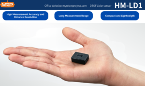
The DTOF Solid State LiDAR HM-LD1 is a compact SPAD dToF LiDAR module designed for real-time depth imaging and 3D point cloud output. With a weight of only 28 g, low 1.2 W power consumption, a 60° × 45° field of view, and multiple interfaces including UART, UDP, and UVC, it is suitable for UAV obstacle avoidance, altitude sensing, terrain following, robotic navigation, and embedded perception development.
Product page: DTOF Solid State LiDAR HM-LD1

View Product Details & Pricing ➔
| Specification | DTOF Solid State LiDAR HM-LD1 |
|---|---|
| Product Type | SPAD dToF Solid-State LiDAR Module |
| Dimensions | 43.5 mm × 30 mm × 26.5 mm |
| Weight | 28 g |
| Indoor Ranging Capability | 0.5–25 m |
| Outdoor Ranging Capability | 0.2–8 m |
| Ranging Accuracy | ±3 cm |
| Field of View | 60° horizontal × 45° vertical |
| Resolution | 40 × 30 |
| Frame Rate | 10 fps |
| Interfaces | UART / UDP / UVC |
| Operating Temperature | -20 ℃ to 60 ℃ |
| Power Consumption | 1.2 W |
| Supported Development Platforms | x86 Windows, x86 Linux, ARM Linux SDK support |
| Typical UAV Applications | Obstacle avoidance, altitude hold, terrain following, inspection, navigation, robotic vision development |
The HM-LD1 provides example ranging measurement data as point cloud and depth data, supporting both visualization and algorithm development. Its compact housing is suitable for autonomous mobile robots and drones where weight affects flight distance. The product is designed for advanced 3D sensing with robust environmental adaptability, supporting real-time depth images and 3D point cloud data for accurate environmental perception. It can be integrated with PCs, Raspberry Pi-style systems, flight controllers, and embedded platforms through UVC, UDP, and UART interfaces.
Download the DTOF SSL HM-LD1 Product Brochure for detailed integration information.
Integration Workflow for Drone LiDAR Systems
Step 1: Define the Mission
Start by defining whether the drone will perform mapping, obstacle avoidance, altitude hold, inspection, navigation, SLAM, or development testing. The mission determines the required range, field of view, accuracy, update rate, data format, and software stack.
⚙️ Shop-floor advice: write the mission down before comparing sensors. If the requirement is “avoid warehouse racks at walking speed,” that leads to one type of sensor. If the requirement is “produce a georeferenced point cloud for a survey client,” that leads to a completely different payload.
Step 2: Confirm Payload and Power Budget
Confirm the drone’s maximum payload and include all supporting hardware in the calculation. The system budget should include the LiDAR, mount, cables, compute module, power regulator, connectors, and protective enclosure. Also verify that the sensor’s power consumption and startup behavior are compatible with the UAV battery and onboard electronics.
⚙️ Practical check: weigh the assembled payload, not just the sensor. Then run hover tests and thermal checks before trusting the system in an operational environment.
Step 3: Choose the Interface
Choose the interface based on the system architecture. UART may be appropriate for embedded controllers and simple data exchange. UDP is useful for network transmission to an onboard computer. UVC may simplify integration when the LiDAR is treated like a camera-style depth stream. SDK support for Windows, Linux, or ARM Linux can reduce development time significantly.
⚙️ Integration tip: choose the interface your software team can support reliably. The cleanest mechanical installation will not help if the data cannot be parsed, timestamped, filtered, and used by the control logic.
Step 4: Decide Mounting Direction
Mounting direction should match the intended sensing function. A downward-facing sensor supports altitude hold and landing assistance. A forward-facing sensor supports obstacle detection. An angled sensor may support terrain following or close-range inspection. Multi-sensor layouts can expand coverage, but they add weight, power demand, and software complexity.
⚙️ Field note: check the installed field of view with the drone fully assembled. Landing gear, prop guards, payload rails, and cable loops can block part of the view if nobody checks the final configuration.
Step 5: Process the Data
Processing may include depth map parsing, point cloud generation, filtering, obstacle thresholding, distance-zone definition, and flight-control logic. Developers may integrate LiDAR data with ROS, OpenCV, Raspberry Pi, Jetson, or embedded Linux systems. The design should consider latency, data rate, CPU load, and fail-safe handling.
⚙️ Control reminder: processing depth data is not enough. The system needs a safe action when the data says something is wrong. That action may be slowing down, stopping, climbing, backing away, landing, or alerting the operator.
Step 6: Test in Real Environments
Test indoors, outdoors, under strong sunlight, around reflective surfaces, near dark objects, under vibration, and during realistic flight motion. Outdoor sunlight, dust, rain, surface reflectivity, temperature, and drone vibration can all change sensor behavior. Flight testing should begin conservatively with safety margins and manual override capability.
⚙️ Hard-earned lesson: a bench test is not a flight test. A sensor that looks perfect on a desk still needs validation in prop wash, sunlight, motion, vibration, and changing backgrounds.
Drone LiDAR Selection Checklist
- ✅ Mission type: mapping, surveying, obstacle avoidance, inspection, altitude hold, or SLAM?
- ✅ Drone payload capacity: can the UAV carry the sensor, mount, cables, and compute board?
- ✅ Sensor weight: is the LiDAR light enough for the drone class?
- ✅ Power consumption: will the sensor reduce flight time significantly?
- ✅ Ranging distance: does the indoor and outdoor range match the mission?
- ✅ Accuracy: is the ranging accuracy sufficient for the control or measurement task?
- ✅ FOV: does the field of view cover the required detection zone?
- ✅ Resolution: is the depth image or point cloud dense enough?
- ✅ Frame rate: is the data update rate fast enough for flight speed?
- ✅ Interface: does it support UART, UDP, UVC, or your preferred development path?
- ✅ SDK support: are Windows, Linux, or ARM Linux SDKs available?
- ✅ Environmental conditions: will it operate in the expected temperature and lighting?
- ✅ Support: does the supplier provide integration and technical support?
The best LiDAR for a drone is not necessarily the longest-range or highest-cost option. The best choice is the sensor that matches the UAV payload, mission distance, environmental conditions, processing pipeline, and safety requirements.
Look at the whole job. A small UAV doing indoor obstacle detection does not need the same system as a survey drone flying a corridor mapping route. A bridge inspection drone working within a few meters of a structure needs stable close-range data, practical mounting, and predictable behavior. A mapping drone needs georeferencing and calibration. Matching the sensor to the mission is what separates a clean integration from an expensive pile of parts.
Common Mistakes When Buying LiDAR for Drones
Mistake 1: Buying Based Only on Maximum Range
Maximum range is only one specification. Buyers should also consider reflectivity, sunlight, accuracy, field of view, resolution, frame rate, latency, and mounting direction. A long-range sensor may still be unsuitable if it is too heavy, too slow, or difficult to integrate.
Here’s the deal: maximum range is often measured under specific conditions. Your drone may fly over dark asphalt, reflective metal, wet concrete, vegetation, glass, or angled surfaces. The useful range in those conditions may be different. Ask for real application data whenever possible.
Mistake 2: Ignoring Payload Weight
Payload weight affects flight time, stability, safety, and drone selection. A sensor that appears affordable may require a larger drone, stronger mount, higher-capacity battery, and more complex approvals. Lightweight modules reduce integration burden for small UAVs.
In the shop, payload creep is real. A team starts with a sensor, then adds a board, then a regulator, then an enclosure, then a better mount. Before long, the aircraft is flying heavy. Keep a payload budget and update it every time hardware changes.
Mistake 3: Confusing Survey Mapping with Real-Time Perception
Survey mapping and real-time perception are different engineering problems. Survey systems prioritize georeferenced deliverables. Perception modules prioritize immediate depth information for control and awareness. Choosing the wrong category can lead to unnecessary cost or insufficient performance.
If you need a certified terrain model, choose a mapping payload. If you need obstacle detection or altitude sensing, choose a perception sensor. They are both LiDAR, but they solve different problems.
Mistake 4: Underestimating Integration Cost
Hardware specifications are only part of the project. Documentation, SDKs, example code, interface compatibility, technical support, and development tools can determine whether the integration succeeds. Always evaluate the full engineering workload.
A cheap sensor with poor documentation can become expensive fast. Engineering hours count. Debugging unknown protocols, unstable drivers, or unclear output formats can cost more than the original hardware savings.
Mistake 5: Not Testing in Outdoor Conditions
Outdoor sunlight, surface reflectivity, rain, dust, vibration, temperature, and motion can affect LiDAR performance. A sensor that works well on a bench should still be validated in realistic flight environments before operational deployment.
Do not wait until the customer demonstration to discover that glare, dark surfaces, or vibration affect your readings. Test early, test conservatively, and build margins into the control logic.
HM-LD1 dToF Solid-State LiDAR: Compact Depth Sensing for UAVs & Robotics
FAQ: LiDAR with Drones
Is there any LiDAR suitable for small drones or beginner UAV projects?
Can drones with LiDAR replace aircraft-based LiDAR for geospatial data collection?
What should I consider before buying a LiDAR drone for surveying on a budget?
What is the difference between drone LiDAR and photogrammetry?
How accurate is LiDAR on a drone?
Can LiDAR help drones avoid obstacles?
Is lightweight LiDAR enough for professional drone mapping?
What interface is best for integrating LiDAR with drones?
Does sunlight affect drone LiDAR performance?
Can drone LiDAR be used indoors?
Build Your UAV Perception System with HM-LD1
If your drone project requires lightweight LiDAR for obstacle avoidance, distance detection, terrain following, altitude hold, or embedded robotics development, explore the DTOF Solid State LiDAR HM-LD1.
📚 References & Further Reading
- Industry Standard: HOKUYO
- Related Guide: visual-based navigation for UAVs






