


Drone LiDAR Sensors for Small UAVs: How to Choose Lightweight, Budget-Friendly 3D Sensing Modules
Small UAVs are getting smarter, lighter, and more autonomous every year, but reliable 3D perception is still one of the harder parts of drone system design. Here’s the deal: a drone can have a solid airframe, a good flight controller, clean wiring, and plenty of battery, but if it cannot understand what is around it, autonomy gets risky fast. Traditional aerial LiDAR payloads used for surveying and mapping can be powerful, but they are often too heavy, expensive, and complex for compact drones, indoor UAVs, educational platforms, inspection prototypes, and early-stage robotics projects.
For many developers, the real challenge is not finding “the most powerful LiDAR.” The real work is choosing a sensor that balances weight, power consumption, range, field of view, software support, environmental reliability, and cost. In the shop, that balance matters more than the biggest number on a datasheet. A sensor that looks impressive on paper can become a headache once you mount it near propellers, route cables through a tight frame, feed it from a noisy power rail, and try to process the data on a small companion computer.
This guide explains how to choose drone lidar sensors for small UAVs, especially lightweight and budget-friendly 3D sensing modules designed for obstacle avoidance, altitude sensing, terrain following, basic point cloud capture, and embedded perception. We will compare key LiDAR technologies, define the specifications that matter most for drone integration, explain when budget LiDAR is appropriate, and show how a compact dToF solid-state module such as the DTOF Solid State LiDAR HM-LD1 can support UAV, robotics, and inspection applications without the complexity of full-scale surveying payloads.
Table of Contents
- 👉 What Are Drone LiDAR Sensors?
- 👉 Why Small UAVs Need Lightweight LiDAR
- 👉 How Drone LiDAR Works: ToF, dToF, Solid-State, and Point Clouds
- 👉 Key Specifications to Compare Before Buying Drone LiDAR Sensors
- 👉 Budget Drone LiDAR vs Professional Surveying LiDAR
- 👉 Drone Integration Guide: Hardware, Software, and Interfaces
- 👉 Recommended Lightweight Drone LiDAR Module: DTOF Solid State LiDAR HM-LD1
- 👉 Application Scenarios for Small UAV LiDAR
- 👉 Buyer’s Checklist for Drone LiDAR Sensors
- 👉 Common Mistakes When Choosing Drone LiDAR Sensors
- 👉 FAQ: Drone LiDAR Sensors for Small UAVs
- 👉 Conclusion: Choosing the Right LiDAR for Your UAV Project
What Are Drone LiDAR Sensors?
LiDAR stands for Light Detection and Ranging. A drone LiDAR sensor emits light pulses and measures the return time of reflected light to estimate distance. Depending on the sensor architecture, a LiDAR system may provide a single distance value, a 2D scan line, a depth map, or a 3D point cloud. In UAV applications, this distance information can help a drone understand how far it is from the ground, a wall, a building, vegetation, industrial equipment, or other obstacles in its flight path.
The phrase drone lidar sensors does not describe one single product category. Look, this is where a lot of teams get tripped up. It includes heavy survey-grade mapping payloads, small altitude sensors, 2D scanning modules, drone obstacle avoidance LiDAR, solid-state dToF LiDAR modules, and robotics perception sensors that can be mounted on UAVs. The best option depends on whether your drone needs to create georeferenced maps, maintain a safe height above ground, avoid obstacles indoors, follow terrain, or collect depth information for robotic vision development.
Drone LiDAR for Mapping vs Drone LiDAR for Perception
Mapping LiDAR prioritizes absolute accuracy, point density, GNSS/RTK integration, IMU synchronization, calibration, and post-processing. Perception LiDAR prioritizes real-time depth, low latency, low weight, low power consumption, and practical integration with embedded computers or flight controllers. A UAV LiDAR sensor for perception may be excellent for obstacle detection or altitude control but still not suitable for commercial land surveying.
That distinction matters because the purchasing decision changes completely. If the drone is expected to produce survey deliverables, the LiDAR is only one piece of a larger measurement chain. You need timing, positioning, calibration, and post-processing. If the drone simply needs to know that a wall is three meters away or that the floor is getting closer during landing, a compact depth sensor may be the smarter tool.
Why the Same Sensor Is Not Right for Every UAV
A large multirotor used for corridor mapping may carry a professional payload with an IMU, RTK receiver, data logger, and mapping software. A small indoor drone may only need a lightweight LiDAR for drones that outputs depth information in real time. Payload capacity, available mounting space, flight speed, software stack, mission type, and budget all influence sensor choice. For projects comparing LiDAR against vision-based depth sensing, our guide to stereo camera systems can help clarify the trade-offs.
In practical engineering terms, “best” means “best fit for the mission.” A sensor that is perfect for a warehouse inspection drone may be the wrong choice for forestry mapping. A LiDAR that works well on a slow indoor platform may not provide enough range or frame rate for fast outdoor flight. Before looking at price, start with the job the drone must do.
Why Small UAVs Need Lightweight LiDAR
Small UAVs are highly sensitive to payload mass. Every gram added to the aircraft affects thrust demand, battery endurance, center of gravity, vibration behavior, and flight controller tuning. A sensor that seems small on a bench may become too heavy once cables, mounting brackets, protection covers, and companion computer requirements are included. This is why lightweight LiDAR for drones is not simply convenient; it is often essential for maintaining usable flight time and predictable flight performance.
In the shop, payload creep is real. First you add the sensor. Then you add a bracket. Then a protective cover. Then a longer cable. Then a converter board. Then a companion computer because the flight controller cannot process the data directly. Suddenly the “small” upgrade is a major payload change. A good drone LiDAR choice keeps the whole installed system in mind, not just the bare sensor weight.
Weight and Power Consumption Directly Affect Flight Time
Drone endurance depends on the complete power system. A heavier payload requires more thrust, while a high-power sensor draws additional energy from the battery or power distribution system. Low-power modules help preserve mission duration and reduce thermal load. For compact UAV platforms, a LiDAR module in the tens-of-grams class is much easier to integrate than a payload weighing hundreds of grams.
Power draw also affects heat. Small UAV frames do not always provide good airflow around electronics, especially if the sensor sits inside a guard or behind a protective window. A low-power LiDAR module reduces the chance of thermal throttling, regulator stress, or temperature-related drift during longer missions.
Compact Size Makes Mechanical Integration Easier
Compact modules can be mounted forward for obstacle detection, downward for altitude hold, or at an angle for terrain following. Small size also reduces aerodynamic drag and makes it easier to fit the sensor inside a protective frame or under the drone body. In inspection drones, where propellers, guards, lights, cameras, and wireless modules compete for space, mechanical simplicity can reduce development time significantly.
Mechanical integration is not just about bolting the sensor on. You need a clean field of view, stable mounting, cable strain relief, protection from impact, and a location that does not shift the center of gravity too far forward or backward. If the optical window is partially blocked by landing gear or propeller guards, the sensor may technically work but produce unreliable data in the exact direction you need most.
Why Budget-Friendly Does Not Mean Low Value
A budget drone LiDAR module can be highly valuable when the application does not require survey-grade deliverables. Educational UAVs, research prototypes, robotics labs, indoor navigation systems, and proof-of-concept inspection drones often need reliable short-to-medium range depth sensing rather than expensive mapping payloads. The right budget-friendly sensor can accelerate development and help teams validate autonomy features before scaling to more advanced systems.
Here’s the deal with budget hardware: it should not be judged by whether it replaces a professional surveying payload. That is the wrong comparison. Judge it by whether it gives your drone usable depth data, fits the aircraft, connects to your processor, and survives the operating environment. If it does those things, it can be a very strong value.
How Drone LiDAR Works: ToF, dToF, Solid-State, and Point Clouds
Most drone LiDAR sensors are based on time-of-flight measurement. The sensor emits light, the light reflects from a target, and the receiver detects the returned signal. Because the speed of light is known, the system can estimate distance based on the measured travel time. The engineering challenge is to perform this measurement reliably in a small, low-power package while handling target reflectivity, sunlight, motion, vibration, and processing latency.
For UAV work, the timing math is only part of the story. A flying platform is moving, vibrating, and constantly changing its angle relative to the target. The sensor may see bright concrete one second, dark asphalt the next, then glass, vegetation, or metal. Good integration means understanding how the sensing technology behaves in those real conditions.
Time-of-Flight Distance Measurement
Time-of-flight, or ToF, is a broad category of distance sensing. In a UAV, ToF data can be used to estimate height above ground, detect a wall ahead of the drone, measure clearance from a structure, or generate depth information for navigation algorithms. Short response time is important because a drone is always moving, and old data can create unsafe decisions.
Latency matters as much as raw range. If a drone is moving toward an obstacle and the perception pipeline takes too long to update, the flight controller may react late. Engineers should consider the entire path from light measurement to flight decision: sensor capture, onboard processing, interface transfer, filtering, object detection, control logic, and motor response.
What dToF Means for Embedded UAV Perception
Direct Time-of-Flight, or dToF, measures the travel time of emitted light pulses directly. SPAD-based dToF sensing can support compact depth modules that output real-time depth images and 3D point cloud data. For embedded UAV perception, a dToF LiDAR module can offer a useful balance between size, power, and spatial awareness. Component-level development in time-of-flight sensing is also supported by semiconductor companies such as STMicroelectronics, which provides reference material for embedded sensing and ToF technologies.
For small drones, that balance is important. You usually do not have unlimited space, power, or processing headroom. A compact dToF sensor that produces structured depth information can be much easier to build around than a larger payload requiring heavier compute and more elaborate synchronization.
Solid-State LiDAR vs Mechanical Scanning LiDAR
Mechanical scanning LiDAR systems may rotate or move optical components to scan a wider area. They can be powerful for mapping or robotics, but moving parts may increase size, cost, complexity, and mechanical vulnerability. Solid-state LiDAR for UAVs avoids large rotating assemblies, making it easier to package into compact drone designs. For readers comparing compact modules with high-end digital LiDAR architectures, companies such as Ouster publish useful resources on modern LiDAR perception systems.
That does not mean mechanical LiDAR is bad. It means you need to match architecture to mission. A survey drone may justify a heavier scanning payload. A compact inspection drone operating near walls, ducts, tanks, or bridge structures may benefit more from a solid-state module with fewer mechanical headaches.
Depth Maps and Point Clouds for UAV Navigation
A depth map is a grid of distance values. A point cloud represents measured points in 3D space. For UAV navigation, these outputs can support obstacle zones, terrain awareness, wall following, docking, inspection distance control, and SLAM development. The usefulness of the data depends on field of view, resolution, frame rate, mounting direction, and the software pipeline that turns raw depth data into flight decisions.
Raw point clouds do not fly the drone by themselves. The onboard system must interpret the data. That may mean defining near, middle, and far obstacle zones; filtering invalid returns; estimating ground plane distance; or feeding depth into a SLAM or navigation stack. The cleaner and more predictable the data path, the faster a team can move from bench testing to controlled flight.
Key Specifications to Compare Before Buying Drone LiDAR Sensors
Choosing drone lidar sensors should start with the mission, not the maximum advertised range. A drone flying indoors at low speed has different requirements from a drone inspecting a dam outdoors or a mapping UAV collecting georeferenced terrain data. Before buying, compare the following specifications carefully.
1. Weight
For small UAVs, ideal LiDAR weight is often measured in tens of grams rather than hundreds. A 28g sensor is realistic for compact drone development, but the installed weight must include cables, adapters, screws, dampers, brackets, and any protective housing. If a companion computer is required, include that mass in the total payload calculation.
As a rule of thumb, do not evaluate sensor mass in isolation. Look at total payload margin, expected flight time, thrust-to-weight ratio, and center of gravity. If adding the LiDAR forces you to use a larger battery, stronger motors, or a bigger frame, the true cost of that sensor just went up.
2. Dimensions
Smaller modules are easier to mount inside frames, under drone bodies, or behind protective windows. Low-profile housings reduce aerodynamic drag and can help maintain a stable center of gravity. Dimensions also affect whether the optical window has a clear view without propeller, landing gear, or frame obstruction.
In tight builds, even a few millimeters can matter. Make sure the connector orientation works with your cable routing. Check whether the sensor needs airflow. Confirm that the mounting position does not expose the module to direct impacts during landing or inspection contact.
3. Ranging Capability
Indoor and outdoor range may differ significantly. Outdoor sunlight introduces optical noise and can reduce the effective detection distance. Always compare indoor, nighttime, and outdoor daytime specifications separately. A small drone LiDAR may provide long indoor range for navigation and shorter outdoor range for inspection or obstacle detection.
Range should also be matched to drone speed. A slow indoor UAV may not need long range. A faster outdoor platform needs enough detection distance to allow processing time, braking distance, and avoidance action. Maximum range is useful only if the data is stable and arrives soon enough to matter.
4. Ranging Accuracy
Accuracy should match the application. Obstacle avoidance may not require survey-grade precision, but altitude hold, terrain following, and close inspection benefit from stable distance measurements. A stated accuracy such as ±3cm can be useful for many perception tasks, but real-world performance should be tested on target materials and under expected lighting.
Do not confuse repeatability, precision, and mapping accuracy. A sensor can provide consistent local distance readings without being suitable for georeferenced surveying. For control support, stable repeatable distance can be more valuable than an impressive absolute accuracy claim under ideal lab conditions.
5. Field of View
Field of view determines how much of the scene the sensor can observe. A wide FOV helps detect obstacles earlier across a broader area, while a narrow FOV may be better for single-direction ranging. A 60° horizontal by 45° vertical FOV is useful for forward perception, zone-based obstacle detection, and close-range environmental awareness.
Mounting direction changes how field of view is used. A forward-facing sensor needs enough horizontal coverage to catch obstacles before the drone turns into them. A downward-facing sensor needs enough coverage to handle pitch and roll changes without losing the ground target. An angled sensor for inspection needs a view that matches the desired standoff distance and approach path.
6. Resolution
Resolution describes how many measurement points are available across the field of view. Higher resolution provides more spatial detail but increases data processing requirements. A 40 × 30 resolution creates a compact depth array that can still support obstacle zones, rough shape detection, altitude sensing, and basic point cloud use cases.
For small UAVs, more resolution is not always better. Higher data volume can increase processor load, memory use, and latency. A moderate-resolution depth array may be easier to filter and convert into control decisions, especially when the drone only needs to know whether an obstacle is present in a defined zone.
7. Frame Rate
Frame rate affects responsiveness. A 10fps depth sensor can support many low-speed UAV and robotics tasks, especially indoor navigation, inspection prototypes, and controlled terrain following. For high-speed flight, engineers must evaluate total system latency, including sensor exposure, data transfer, filtering, perception algorithms, and flight controller response.
Frame rate should be judged against mission speed. A slow inspection drone hovering near a structure may work well with 10fps depth updates. A racing-style drone or fast autonomous platform likely needs a faster perception loop and more aggressive prediction logic. Always test at realistic motion speeds, not only while the drone sits still on a bench.
8. Interface Options
Interface compatibility can determine whether a sensor is easy or difficult to integrate. UART is useful for embedded controllers and simple data paths. UDP is practical for networked systems and Linux companion computers. UVC can simplify development by allowing camera-like depth streaming. Match the interface to your Raspberry Pi, Jetson, flight controller, PC, or embedded processor.
This is one of those details that can save or waste weeks. A sensor with a familiar interface and good SDK support is much easier to evaluate. If the data path is poorly documented, even a capable sensor can slow the project down.
9. Power Consumption
Low power consumption preserves UAV battery life and reduces heat. A 1.2W LiDAR module is attractive for compact platforms, but the total system power budget should include the companion computer, communication modules, voltage regulators, and any cooling hardware. Clean and stable power is also important because motor and ESC noise can affect sensor reliability.
Use a regulated supply with enough margin. Bench-test the sensor with motors off, then with motors running, then during throttle changes. Some problems only show up when the power system is under real load. If the LiDAR drops frames or communication becomes unstable when motors spin up, check grounding, EMI, regulator capacity, and cable routing.
10. Operating Temperature
Industrial UAVs may operate in warehouses, tunnels, winter conditions, hot outdoor environments, or enclosed frames with limited airflow. An operating temperature range of -20°C to 60°C supports many laboratory, field, and inspection conditions. However, the complete system should be tested because enclosure design and solar heating can increase internal temperature.
Temperature ratings are not just paperwork. Heat can affect electronics, optics, regulators, adhesives, and mechanical mounts. Cold weather can affect batteries and cable stiffness. If the drone will fly in harsh environments, test the complete assembly, not just the sensor module.

Budget Drone LiDAR vs Professional Surveying LiDAR
A common mistake is assuming that every drone LiDAR sensor is intended for land surveying. In reality, budget drone LiDAR and survey-grade aerial LiDAR solve different problems. Budget modules are typically designed for perception, control support, robotics development, obstacle avoidance, altitude sensing, and inspection assistance. Professional surveying payloads are designed to generate accurate georeferenced deliverables.
Here’s the clean way to think about it: perception LiDAR helps the drone understand its nearby environment in real time. Surveying LiDAR helps produce measured datasets tied to real-world coordinates. Those are related technologies, but they are not the same job.
When a Budget LiDAR Module Is the Right Choice
A budget dToF LiDAR module is often the right choice for drone obstacle avoidance, altitude hold, low-speed terrain following, indoor navigation, smart inspection prototypes, educational platforms, and robotics research. These applications benefit from real-time depth information but do not necessarily require centimeter-grade global positioning, high-density mapping, or advanced post-processing.
Budget modules are especially useful when a team is still proving the autonomy concept. You can validate mounting angles, depth processing, obstacle zones, and flight behavior before committing to a larger payload. That kind of practical iteration matters when deadlines and prototype budgets are tight.
When You Need a Survey-Grade UAV LiDAR Payload
Commercial land surveying usually requires much more than a depth sensor. A professional payload may include long-range LiDAR, high point density, RTK or PPK GNSS, a calibrated IMU, timing synchronization, boresight calibration, mapping software, and post-processing workflows. If your deliverable is a topographic map, corridor survey, forestry measurement, or engineering-grade model, a lightweight perception module alone is not enough.
Trying to force a perception sensor into a survey workflow usually leads to disappointment. The local point cloud may be useful for awareness, but without positioning, synchronization, and calibration, it will not meet professional mapping requirements. If the client expects measurable georeferenced output, choose the correct class of system from the start.
How to Avoid Overbuying or Underbuying
Overbuying wastes budget, adds weight, and creates unnecessary integration complexity. Underbuying creates disappointing performance and unreliable mission results. The best approach is to define the required output first: real-time obstacle awareness, height control, depth map, local point cloud, or georeferenced survey deliverable. Then choose the UAV LiDAR sensor class that matches that requirement.
One practical method is to write the desired sensor output in plain language. For example: “The drone must detect a wall within 5 meters and slow down,” or “The drone must maintain 2 meters above the floor indoors,” or “The system must produce survey-grade terrain data.” Once the output is defined, the sensor choice becomes much clearer.
Drone Integration Guide: Hardware, Software, and Interfaces
Successful drone LiDAR integration requires mechanical, electrical, and software planning. A good sensor can still perform poorly if it is mounted behind a propeller arc, powered from a noisy rail, installed without vibration consideration, or connected to software that cannot process data fast enough.
In the shop, integration failures are usually not mysterious. They come from blocked optics, bad power, loose mounts, EMI, unsupported drivers, or unrealistic expectations. Slow down early, validate each subsystem, and the flight tests will go much better.
Mechanical Mounting
Forward-facing mounting is common for obstacle avoidance. Downward-facing mounting is useful for altitude sensing and height-above-ground estimation. Angled mounting can support terrain following or structure inspection. The optical window should have a clear field of view, free from propeller obstruction, landing gear, cables, or protective guards. Consider vibration isolation, but avoid flexible mounts that allow the sensor angle to change during flight. Protect the optical window from dust, water droplets, scratches, and direct impact.
The mounting bracket should be stiff enough to hold alignment during acceleration, braking, and vibration. If the sensor shifts a few degrees during flight, the depth data may no longer match the assumed coordinate frame. For obstacle avoidance and terrain following, that alignment error can matter.
Electrical Integration
Confirm voltage requirements from the supplier documentation before powering the sensor. Estimate current draw from the stated power consumption and design for stable regulated power. Avoid sharing noisy rails with motors or ESCs when possible. EMI from ESCs, high-current wiring, telemetry radios, and video transmitters can affect sensitive electronics, so wiring layout and grounding matter. Bench testing with motors off and motors on is essential.
Keep high-current motor wiring away from sensor data lines where possible. Use proper grounding and avoid long unsupported cables that can act like antennas. If you are using adapters or converters, test those as part of the system. A LiDAR module may be stable by itself but unreliable through a poor-quality adapter.
Data Interface Selection: UART, UDP, or UVC
UART is useful when a flight controller or microcontroller needs basic range or status data. UDP is better suited to networked systems and Linux companion computers that process depth maps or point cloud streams. UVC can be convenient for PC-based development and camera-style depth streaming. The correct interface depends on bandwidth, driver support, latency, and the computing platform selected for the UAV.
For early development, it is often smart to start with the interface that gives the fastest visibility into the data. Once the depth stream is understood, the team can move toward the deployment interface that best fits the flight hardware. Do not underestimate the value of easy debugging during the first build.
Software Development and SDK Support
SDK support reduces integration time. The HM-LD1 supports SDKs for x86 Windows, x86 Linux, and ARM Linux, enabling development across desktop, industrial PC, Raspberry Pi, Jetson-class, and embedded Linux environments. If your team is evaluating different perception architectures, compare LiDAR with stereo camera depth sensing before finalizing your UAV hardware stack. Many teams begin with PC testing, then migrate to ARM Linux for flight-ready prototypes.
Good software support can be the difference between a weekend prototype and a month of reverse engineering. Look for clear documentation, sample code, data format explanations, and platform support that matches your target hardware. If the SDK runs on the same operating system as your companion computer, your integration risk drops immediately.
Testing Before Flight
Start with bench tests. Verify power, communication, SDK operation, and distance readings indoors. Test different surfaces, including dark materials, reflective objects, angled walls, vegetation, concrete, and metal. Then test under outdoor sunlight and shadows. After installation, test with motors off, then motors on, before attempting controlled flight. Never rely on a new drone LiDAR sensor for autonomous flight without staged validation and fail-safe behavior for invalid or missing data.
A proper test plan should include failure cases. What happens if the sensor reports invalid data? What happens if the cable disconnects? What happens if sunlight reduces range? What happens if the drone faces glass, water, or a low-reflectivity object? Safe autonomy depends on knowing how the system behaves when the sensor is not giving ideal data.
Recommended Lightweight Drone LiDAR Module: DTOF Solid State LiDAR HM-LD1
The DTOF Solid State LiDAR HM-LD1 is a compact dToF LiDAR module designed for real-time depth imaging and 3D point cloud output. For small UAVs, robotics platforms, and embedded perception projects, it offers a practical balance of size, weight, interface flexibility, and depth sensing capability. At only 28g, with 1.2W power consumption, multiple interfaces, and SDK support across Windows, Linux, and ARM Linux environments, HM-LD1 is suitable for drone altitude sensing, obstacle avoidance, terrain following, inspection prototypes, and robotic vision development.
Look, this is not positioned as a heavy survey payload. It is a compact perception module for teams that need usable 3D sensing in a small package. That makes it a practical fit for labs, UAV developers, robotics builders, and inspection teams that want depth data without designing around a large and expensive mapping system.
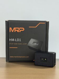
| Specification | DTOF Solid State LiDAR HM-LD1 |
|---|---|
| Product Name | DTOF Solid State LiDAR HM-LD1 |
| Product URL | View Product Page |
| Dimensions | 43.5mm × 30mm × 26.5mm |
| Weight | 28g |
| Ranging Capability | Indoor: 0.5–25m; Outdoor: 0.2–8m |
| Ranging Accuracy | ±3cm |
| Field of View | 60° horizontal × 45° vertical |
| Resolution | 40 × 30 |
| Frame Rate | 10fps |
| Interface | UART / UDP / UVC |
| Operating Temperature | -20°C to 60°C |
| Power Consumption | 1.2W |
| SDK Support | x86 Windows, x86 Linux, ARM Linux |
| Typical Applications | UAV altitude hold, obstacle avoidance, terrain following, robot navigation, SLAM support, smart inspection, distance detection, robotic vision development |
View Product Details & Pricing ➔
For detailed technical documentation, download the DTOF SSL HM-LD1 Product Brochure.
Why HM-LD1 Fits Small UAV Development
HM-LD1 is positioned for embedded perception rather than heavy survey payload workflows. Its compact dimensions of 43.5mm × 30mm × 26.5mm and 28g weight make it practical for small drone frames where every gram affects endurance. The 1.2W power consumption is also attractive for battery-powered systems, especially when designers must preserve energy for motors, radio communication, and onboard processing.
That combination matters in real builds. A drone that can carry a sensor comfortably is easier to tune, easier to test, and safer to operate. When the payload is too close to the aircraft’s limit, every flight becomes less forgiving.
Depth Map and Point Cloud Output
HM-LD1 is a solid-state LiDAR module based on SPAD dToF technology. It delivers real-time depth images and 3D point cloud data for environmental perception. For UAV developers, these outputs can support obstacle zones, altitude estimation, distance detection, indoor navigation research, and robotic vision development. The 40 × 30 resolution is suitable for compact depth sensing tasks where a lightweight module is more important than high-density mapping.
For obstacle avoidance, this kind of output can be turned into practical safety zones. For altitude control, the depth information can help estimate distance to the ground or nearby surfaces. For robotics research, the same data can feed perception algorithms, SLAM experiments, or multi-sensor fusion pipelines.
Interface Flexibility for UAV Developers
The module supports UART, UDP, and UVC interfaces. This flexibility helps during both prototyping and deployment. Developers can evaluate depth data on a PC, connect to Linux companion computers, or build embedded perception pipelines. SDK support for x86 Windows, x86 Linux, and ARM Linux makes it relevant for teams working with desktop computers, Raspberry Pi, Jetson-style systems, and other embedded platforms.
This is a practical advantage. Early prototypes often start on a laptop or desktop where visualization and debugging are easier. Once the concept works, the system can move to ARM Linux or another embedded platform for flight. A sensor that supports both stages helps reduce redesign.
Environmental Performance Indoors and Outdoors
HM-LD1 supports indoor ranging from 0.5m to 25m and outdoor ranging from 0.2m to 8m. The outdoor specification is important because bright sunlight can reduce effective LiDAR range. According to the product description, accurate measurement at distances up to 8 meters outdoors on a clear summer day can support distance detection for difficult-to-approach structures such as bridges, expressways, and dams. As with all drone lidar sensors, real-world performance should be validated with the target surfaces, lighting, and flight speeds expected in the application.
Outdoor validation is especially important for inspection work. Concrete, steel, vegetation, painted surfaces, wet surfaces, and dark materials can all return light differently. The best approach is to test with the actual types of surfaces your drone will see in the field.
Application Scenarios for Small UAV LiDAR
Small UAV LiDAR can support many applications where real-time depth is more important than survey-grade mapping. The same 3D sensing module may also be used across drones, ground robots, cameras, and security systems, helping engineering teams reuse perception pipelines across multiple platforms.
That reuse is valuable. If your team builds both UAVs and ground robots, a compact depth sensor with common interfaces can reduce software fragmentation. You can test navigation ideas on a ground robot first, then adapt the same concepts to aerial platforms.
UAV Altitude Hold
A downward-facing drone altitude sensor can help estimate height above ground when barometer or GPS altitude is insufficient. This is useful for low-altitude flight, indoor drones, landing assistance, and height control near structures. Stable filtering and proper flight controller integration are required because ground texture, angle, and reflectivity can affect readings.
Altitude hold is one of the most practical uses for compact LiDAR. Barometers drift. GPS altitude can be rough. Vision systems may struggle with texture or lighting. A downward depth sensor can provide local distance information that helps the aircraft maintain a more consistent height in controlled conditions.
Obstacle Avoidance
A forward-facing depth map LiDAR can detect walls, trees, racks, machinery, bridge elements, and other obstacles. The depth data can be converted into warning zones or avoidance commands. For small drones, obstacle avoidance is not only about range; it also depends on field of view, latency, processing reliability, and fail-safe design.
Do not treat obstacle avoidance as a single sensor feature. It is a system behavior. The LiDAR provides distance data, but the drone still needs logic for slowing down, stopping, rerouting, or handing control back to the pilot. Safe design means planning what the aircraft should do when the data is uncertain.
Terrain Following
Terrain following requires a UAV to maintain a desired height above changing ground. A UAV terrain following sensor must provide stable distance measurements and update quickly enough for the drone’s speed. For low-speed inspection or research platforms, compact dToF LiDAR can be useful when combined with flight controller logic and appropriate filtering.
Terrain following works best when the aircraft speed, sensor range, frame rate, and control loop are matched. If the drone moves too fast for the sensor update rate, it may react late to rising terrain. Start slow, tune carefully, and increase speed only after the system behaves predictably.
Bridge, Expressway, and Dam Inspection
Industrial inspection teams often need to measure distance to structures that are difficult or unsafe for people to approach. Lightweight drone LiDAR can help maintain standoff distance from bridges, expressways, dams, retaining walls, and industrial equipment. Outdoor range expectations must be realistic, especially under strong sunlight and on low-reflectivity surfaces.
In inspection work, distance control can protect both the drone and the structure. A compact LiDAR module can help the system maintain a safer offset from concrete walls, steel beams, or other hard surfaces. That said, the pilot or autonomy system should still account for wind, prop wash, GPS issues, and changing surface angles.
Indoor Drone Navigation
Warehouses, factories, laboratories, tunnels, and other GPS-denied environments require local sensing. LiDAR can support obstacle awareness, wall distance measurement, localization research, and indoor SLAM. It is usually combined with IMUs, optical flow, visual odometry, or other sensors for robust autonomous navigation.
Indoor flight is unforgiving because obstacles are close and GPS is not available. A LiDAR module can give the drone valuable depth awareness, but a complete navigation system still needs sensor fusion, reliable state estimation, and careful flight limits. For research teams, compact LiDAR is often a practical starting point for GPS-denied autonomy.
Robotics and Multi-Platform Development
Many teams develop one perception stack for multiple robots. A compact point cloud sensor can be tested on a ground robot, then adapted to a UAV or smart camera system. HM-LD1’s platform support and interface flexibility make it relevant for development teams building reusable perception and positioning solutions.
This is useful for education, prototyping, and commercial R&D. A sensor that works across Windows, Linux, and ARM Linux gives engineers room to experiment before locking down the final embedded architecture.
Buyer’s Checklist for Drone LiDAR Sensors
Use this checklist before selecting a drone LiDAR sensor for a UAV project:
- ✅ Define whether your project needs perception, mapping, surveying, or inspection support.
- ✅ Confirm the UAV payload capacity and available mounting space.
- ✅ Check total sensor weight including cables, mounts, and protective housing.
- ✅ Compare indoor and outdoor ranging capability separately.
- ✅ Confirm ranging accuracy is sufficient for the application.
- ✅ Choose a field of view that matches the sensor mounting direction.
- ⚙️ Evaluate resolution and frame rate for the UAV’s flight speed.
- ⚙️ Confirm interface compatibility: UART, UDP, UVC, USB adapter, Ethernet, or embedded serial.
- ⚙️ Review SDK support for Windows, Linux, ARM Linux, Raspberry Pi, Jetson, or other platforms.
- ⚙️ Calculate power budget and thermal impact.
- ⚙️ Test performance in sunlight, shadows, reflective surfaces, and low-texture environments.
- ✅ Plan fail-safe behavior if LiDAR data is lost or unreliable.
- ✅ Ask the supplier for integration support, sample code, and documentation.
For teams building UAVs, robots, and embedded sensing systems, supplier expertise can be as important as the sensor itself. Learn more about our perception and positioning module expertise if you need help matching a LiDAR module to your application.
Here’s the practical buying advice: do not buy from a spec sheet alone. Ask how the sensor is normally mounted, what development platforms are supported, what data formats are available, how outdoor range is specified, and what examples are available. A supplier that understands UAV integration can save a lot of engineering time.
Common Mistakes When Choosing Drone LiDAR Sensors
Mistake 1: Assuming All Drone LiDAR Sensors Are Survey-Grade
Perception LiDAR and mapping LiDAR are different. A compact dToF LiDAR module can be excellent for obstacle detection, altitude sensing, and robotic vision, but it does not automatically provide georeferenced survey data. Be clear about whether your deliverable is a control signal, a depth map, a local point cloud, or a professional map.
If you need a professional map, plan for the full measurement system. If you need local awareness, choose a sensor that is light, fast enough, easy to integrate, and appropriate for the operating range.
Mistake 2: Ignoring Sunlight Performance
Outdoor range can be much shorter than indoor range. Sunlight, reflectivity, weather, and surface angle all affect LiDAR performance. Always review outdoor specifications and test in realistic conditions before using the sensor for flight-critical behavior.
A sensor that performs well in a lab may behave differently on a bright summer day near concrete, metal, water, or dark asphalt. Test outdoors before trusting the data for autonomy.
Mistake 3: Choosing Range Without Considering Field of View
A long-range single-point sensor and a shorter-range depth sensor solve different problems. If the drone needs to detect obstacles across a forward area, field of view and resolution may matter more than maximum distance. If the drone only needs downward height measurement, a narrower sensor may be acceptable.
Range is only useful in the direction the sensor can actually see. A narrow beam may miss obstacles outside its line of sight. A wider depth sensor may provide better situational awareness even if its maximum range is shorter.
Mistake 4: Forgetting Software Integration
SDK support, drivers, documentation, sample code, and interface options can reduce development time. A sensor that looks excellent on paper may delay a project if the data format is difficult to parse or the target processor is unsupported.
Before buying, confirm that your team can read and process the data on the intended platform. If you plan to use ARM Linux, make sure ARM Linux support is actually available. If you plan to connect to a flight controller, confirm the data rate and message format.
Mistake 5: Underestimating Flight Testing Requirements
Bench performance does not guarantee flight performance. Vibration, EMI, propeller airflow, sunlight, movement, and changing target angles can all affect readings. Staged testing is essential before autonomous functions are enabled.
Good testing starts slow. Validate the sensor on the bench, then on the drone with motors off, then with motors on, then in controlled hover, then in low-speed flight. Do not jump straight from “it works on USB” to autonomous obstacle avoidance.
FAQ: Drone LiDAR Sensors for Small UAVs
Is there any LiDAR for small drones?
What entry-level drone LiDAR sensor is suitable for beginners or budget UAV projects?
Can budget drone LiDAR sensors be used for land surveying or mapping?
What is the difference between drone LiDAR and a drone camera?
How much does weight matter when selecting a drone LiDAR sensor?
What range do drone LiDAR sensors need?
Is solid-state LiDAR better for small UAVs?
Can drone LiDAR work outdoors in sunlight?
What interface is best for connecting LiDAR to a drone?
Can LiDAR help a drone fly indoors without GPS?
What does LiDAR resolution mean for drone applications?
How should I test a drone LiDAR sensor before flight?
Conclusion: Choosing the Right LiDAR for Your UAV Project
The best drone LiDAR sensor depends on the mission. Small UAVs need compact, low-power, lightweight modules that fit the aircraft’s payload capacity and software architecture. Budget-friendly LiDAR is often ideal for development, obstacle avoidance, altitude sensing, terrain following, indoor navigation, smart inspection, and robotic perception. However, it should not be confused with a full professional surveying payload that includes RTK, IMU synchronization, calibration, and post-processing.
The DTOF Solid State LiDAR HM-LD1 is a practical example of a lightweight dToF solid-state LiDAR option for embedded UAV and robotics perception. With 28g weight, 1.2W power consumption, 40 × 30 depth resolution, 10fps frame rate, UART/UDP/UVC interfaces, and SDK support for x86 Windows, x86 Linux, and ARM Linux, it is designed for teams that need useful 3D sensing without the size and complexity of high-end mapping systems.
Here’s the deal: choose the sensor that matches the aircraft and the job. If you need local depth for control and perception, a compact module can be the right move. If you need professional survey data, plan for the full payload stack. The smartest drone LiDAR decision is the one that keeps the vehicle flyable, the data usable, and the development path realistic.
If you are developing a UAV perception system and need help choosing the right LiDAR, RTK, or embedded sensing module, contact our team for product matching and integration support.
📚 References & Further Reading
- Industry Standard: Ouster | STMicroelectronics
- Related Guide: Stereo camera and depth sensing alternatives | DTOF Solid State LiDAR HM-LD1 | About our UAV and robotics perception solutions






