

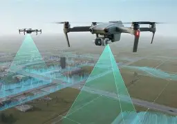
Affordable LiDAR Scanning for Robots, Drones & SLAM: How to Choose a Budget LiDAR That Actually Works
Affordable LiDAR scanning is not some lab-only idea anymore. Here’s the deal: compact dToF and solid-state LiDAR modules have made real-time depth sensing practical for robots, drones, embedded devices, security systems, inspection tools, and research platforms without forcing teams into a six-figure sensing stack. A few years back, if you wanted usable LiDAR, you were usually looking at survey hardware, automotive-grade perception systems, or bulky rotating sensors that were expensive, power-hungry, and not exactly friendly to small machines. That has changed.
Look, the important point is this: the cheapest LiDAR sensor is not automatically the best budget LiDAR. In the shop, we see this mistake all the time. A team buys the lowest-priced module they can find, then burns two weeks fighting drivers, bad documentation, weak outdoor performance, limited range, unstable outputs, or an interface that does not play nicely with the controller. By the time the engineer has built custom parsing tools, designed a workaround, and retested the whole platform, that “cheap” sensor is not cheap anymore. It is a project delay with a connector on it.
This guide walks through how to choose an affordable LiDAR scanner that actually works in real robotics, UAV, SLAM, and embedded perception applications. We will compare budget LiDAR expectations against expensive mapping systems, explain dToF and solid-state scanning principles, break down the specifications that matter, and show where a compact module such as the DTOF Solid State LiDAR HM-LD1 fits into practical engineering work.
If you are evaluating LiDAR for AMRs, AGVs, UAVs, Raspberry Pi, Jetson-class computers, ROS development, smart inspection, security sensing, or prototype-to-production robotic vision, this guide is built for you. The goal is not to hype LiDAR as magic. The goal is to help you choose a sensor that gives you usable distance data, reasonable integration time, and predictable behavior when the machine leaves the bench and starts working in the real world.
Table of Contents
- 👉 What Is Affordable LiDAR Scanning?
- 👉 Why Budget LiDAR Is Growing in Robotics, Drones, and SLAM
- 👉 How LiDAR Scanning Works: dToF, iToF, Solid-State, and Mechanical LiDAR
- 👉 Budget LiDAR Specs That Actually Matter
- 👉 Best Applications for Affordable LiDAR Scanning
- 👉 What Low-Cost LiDAR Cannot Do Well
- 👉 Affordable dToF LiDAR Example: HM-LD1 Solid-State LiDAR
- 👉 Integration Workflow for Robots, Drones, and Embedded Platforms
- 👉 Affordable LiDAR Selection Checklist
- 👉 FAQ: Affordable LiDAR Scanning
- 👉 Final Thoughts: Choose Affordable LiDAR by Engineering Fit, Not Price Alone
What Is Affordable LiDAR Scanning?
Affordable LiDAR scanning means using lower-cost LiDAR hardware to capture distance, depth, or 3D spatial data in a way that is practical for engineering and deployment. In industrial and robotics terms, affordable does not mean disposable, toy-grade, or “good enough if nobody checks too closely.” It means the sensor delivers enough performance for the job without forcing the buyer into the cost, size, power draw, and integration burden of a premium survey or automotive platform.
That distinction matters. A warehouse robot that only needs to see pallets, human legs, aisle edges, and docking targets does not always need a survey-grade scanner. A drone doing low-altitude terrain following does not necessarily need a full aerial mapping payload. A research team building a prototype SLAM system may need clean depth data, stable drivers, and a usable SDK more than it needs a massive point cloud. Affordable LiDAR scanning lives in that practical middle ground.
Affordable LiDAR can include single-point rangefinders, 2D scanning LiDAR, compact 3D depth modules, solid-state dToF sensors, and embedded depth devices that rely on LiDAR principles. The best choice depends on the job. A mobile robot operating indoors has a very different sensing problem than a UAV flying outdoors over uneven ground. A security sensor watching an entry zone does not need the same specifications as a mapping robot building a dense indoor model.
Affordable Does Not Mean Lowest Cost
Here’s the deal: the purchase price is only one line item. The real cost includes software integration, driver stability, data format, calibration effort, mechanical mounting, support quality, supply stability, and how much time your engineering team wastes trying to make the sensor behave. A module that costs less on paper can become expensive fast if it fails in bright sunlight, drops frames, lacks documentation, or outputs data in a format your software stack cannot use cleanly.
In the shop, a good budget sensor is one you can wire up, read reliably, mount securely, and validate under the conditions your machine will actually see. If you have to write everything from scratch, reverse-engineer the data stream, or redesign the enclosure because the field of view is wrong, you are not saving money. You are moving cost from purchasing to engineering.
Affordable Means Fit-for-Purpose
For robotics, affordable LiDAR can support obstacle avoidance, presence detection, people detection, docking assistance, short-range navigation, SLAM support, smart inspection, and prototype development. For drones, it can support altitude hold, landing assistance, low-altitude obstacle sensing, and terrain following. For embedded products, it can provide a depth-aware input where size, weight, power consumption, and interface simplicity matter more than survey-grade point density.
The right module is the one that helps the whole system work. Not the flashiest spec sheet. Not the lowest price. Not the sensor with the biggest marketing claim. The right LiDAR is the one that matches your range, accuracy, field of view, frame rate, software, compute platform, and operating environment.
Why Budget LiDAR Is Growing in Robotics, Drones, and SLAM
Budget LiDAR is growing because robots and UAVs need better environmental awareness without the cost and complexity of high-end mapping hardware. Cameras are useful, but they struggle with depth ambiguity, low texture, shadows, glare, motion blur, and changing light. Ultrasonic sensors are inexpensive, but they provide limited spatial information and can be unreliable around angled surfaces or soft materials. Basic infrared proximity sensors are compact, but they usually do not provide enough range or scene structure for serious navigation.
LiDAR fills that gap by measuring distance directly. Instead of guessing depth from image features, a LiDAR module sends out light and measures the return. That direct ranging behavior makes it useful for machines that need to move, stop, avoid obstacles, hold altitude, detect objects, or build some level of spatial awareness. It gives control software something concrete to work with.
At the same time, semiconductor-driven LiDAR innovation has reduced size, weight, and power requirements. Solid-state architectures are especially valuable because they remove many of the moving mechanical parts that made older scanners bulky or fragile. For small robots and drones, that is a big deal. A compact sensor that draws little power and mounts cleanly is often easier to deploy than a larger mechanical unit with more maintenance concerns.
From Survey-Only LiDAR to Embedded Perception
Historically, LiDAR was associated with survey trucks, autonomous vehicle prototypes, aerial mapping, and expensive geospatial workflows. Those systems still matter, and they are still the right answer for professional mapping. But LiDAR is no longer limited to those applications. Today, compact modules can generate depth images and point cloud data for machine perception in embedded devices and mobile robots.
That shift is why affordable LiDAR scanning is such a useful topic for engineers. The technology has moved from specialized mapping into general-purpose sensing. A robot does not always need a perfect map. Sometimes it just needs to know that a box is three meters ahead, the floor drops off, a person entered the work zone, or a wall is close enough to affect the path planner.
Why Engineers Want Smaller, Lighter LiDAR
UAV payload limits are unforgiving. Every gram matters. Mobile robots also have limited mounting space, limited cable routing, and limited power budgets. Battery-powered embedded devices must manage heat and runtime carefully. Research teams need sensors that connect to Linux, ARM boards, x86 systems, flight controllers, or development platforms without turning the integration effort into a separate project.
This is where affordable LiDAR becomes practical. A sensor that is light, low-power, and easy to integrate can unlock product development much faster than a larger and more complex platform. For a prototype team, that can mean getting usable test data in days instead of weeks. For a production team, it can mean lower total system cost, simpler installation, and fewer field failures.
For a broader view of robotics, UAV, and intelligent sensing use cases, see our applications overview.
How LiDAR Scanning Works: dToF, iToF, Solid-State, and Mechanical LiDAR
To judge affordable LiDAR scanning correctly, buyers need a basic understanding of how the hardware works. LiDAR systems emit light and measure the reflected return. The main differences are how the system measures distance, how it covers the scene, how much mechanical movement is involved, and what kind of data comes out on the other side.
For an engineer, the key question is not just “Is it LiDAR?” The better question is “What type of LiDAR is it, what data does it output, and does that data fit my control problem?” A single-point rangefinder, a 2D spinning scanner, and a compact solid-state depth module can all be LiDAR, but they behave very differently in a robot.
Direct Time-of-Flight LiDAR
Direct time-of-flight, or dToF, calculates distance by measuring the time it takes for emitted light to return from a target. The sensor sends out a pulse, detects the reflected light, and converts the travel time into distance. That makes dToF well suited for range measurement, depth sensing, and compact modules that need real-time scene awareness.
The DTOF Solid State LiDAR HM-LD1 is based on SPAD dToF technology and provides real-time depth images and 3D point cloud data. For engineers, the appeal of dToF is its direct relationship between emitted pulse and measured range. That makes it useful for control, navigation, obstacle detection, altitude sensing, and practical perception tasks where repeatable distance readings matter.
Indirect Time-of-Flight LiDAR
Indirect time-of-flight, or iToF, estimates distance by measuring the phase shift between emitted and reflected modulated light. It can be useful for short-range depth imaging and embedded sensing applications. iToF and dToF are both time-based distance technologies, but they have different implementation tradeoffs, especially around range, sunlight behavior, ambiguity handling, and system design.
If you want a deeper technical comparison, read our guide on iToF vs dToF LiDAR technology.
Solid-State LiDAR
Solid-state LiDAR matters because it removes or reduces the need for spinning mechanical assemblies. That usually improves compactness, mounting flexibility, durability, and integration simplicity. For a small robot or drone, the physical design can matter as much as the ranging performance. A sensor that is easy to mount, easy to power, and easy to protect is often more useful than a technically impressive unit that does not fit the platform.
Solid-state designs are also attractive for embedded systems because they can reduce vibration sensitivity, mechanical wear, and alignment issues. There are still optical, thermal, and environmental design concerns, but eliminating bulky rotation hardware makes the whole system easier to package.
Mechanical Scanning LiDAR
Mechanical LiDAR typically uses rotating or oscillating assemblies to cover a wider scene. In mapping, autonomous driving, and some high-performance navigation systems, that wide scan coverage remains valuable. Mechanical scanners can provide broad awareness and dense spatial data depending on the architecture.
But mechanical complexity can increase size, weight, maintenance, power draw, and price. For many affordable LiDAR scanning projects, especially in robotics, UAV control, embedded devices, and smart inspection, a compact solid-state approach is often the more practical route. It depends on the job. If you need a dense panoramic map, you may need a different class of scanner. If you need forward depth awareness, solid-state dToF may be exactly the right tool.
LiDAR development is also being accelerated by semiconductor and perception technology companies such as Onsemi and automotive LiDAR specialists such as Luminar Technologies.
Budget LiDAR Specs That Actually Matter
When comparing affordable LiDAR scanners, it is easy to focus on price, maximum range, or the biggest number printed on the datasheet. That is a mistake. Real value comes from whether the sensor meets the system requirements under real operating conditions. Several specifications matter more than others, and they need to be judged together.
Range
Range is usually the first number buyers look at, but it needs context. Indoor range and outdoor range are often very different. Bright sunlight can reduce effective distance. Dark surfaces return less light. Reflective materials can create odd responses. Fog, dust, rain, and glass can all complicate the measurement.
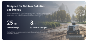
For a robot or drone, a sensor that measures up to 25 meters indoors and up to 8 meters outdoors can still be very useful if the application is obstacle avoidance, navigation support, landing assistance, terrain following, or local awareness. It would not be the right choice for long-range survey mapping, but that is not what this class of sensor is built for.
Accuracy
Accuracy tells you how trustworthy each distance measurement is. For affordable LiDAR scanning, ±3 cm can be very practical for obstacle avoidance, people detection, robot navigation support, UAV terrain following, distance detection, and many research applications. It gives the control system enough confidence to make useful decisions.
It is not suitable for metrology, certified surveying, structural deformation analysis, or precision dimensional inspection. That is fine. Every sensor has an operating lane. The trick is knowing whether your job requires centimeter-class proximity data or survey-grade measurement traceability.
Field of View
Field of view defines how much of the scene the sensor can observe. A 60° horizontal by 45° vertical field of view is a strong fit for many forward-facing perception tasks. It captures meaningful spatial context without requiring a large sensor package. For compact robots, that balance can be more valuable than extremely wide coverage.
The field of view should match the mounting position and the motion of the platform. A forward-facing robot may need a different viewing angle than a downward-facing drone. A security application watching a doorway may care more about vertical coverage than a warehouse robot scanning aisle edges. Do not buy field of view on paper. Match it to the geometry of the job.
Resolution
Resolution affects how much spatial detail the sensor can produce. A 40 x 30 depth grid gives 1,200 measurement points per frame. That is modest compared with high-end survey systems, but it is useful for embedded perception and real-time depth awareness. Many control tasks do not need a beautiful point cloud. They need enough points to detect obstacles, estimate distance, and classify simple spatial situations.
For affordable LiDAR scanning, the question is not whether the output looks impressive in a visualization tool. The question is whether it gives your software enough reliable information to act safely and consistently.
Frame Rate
Frame rate matters because moving machines cannot wait too long for updated information. At 10 fps, a sensor can support many moderate-speed robotics and UAV applications, especially when the platform uses conservative motion planning and good filtering. For fast drones, high-speed AMRs, or dynamic industrial environments, frame rate deserves careful testing.
A frame rate that is adequate for a slow inspection robot may be too slow for a fast-moving autonomous platform. Look at vehicle speed, stopping distance, processing latency, and control loop timing together. LiDAR frame rate is only one part of the timing chain.
Interfaces
Interfaces are often overlooked, but they can make or break a project. UART is useful for simple embedded controllers and microcontroller-based systems. UDP works well for networked transfer and higher-level software systems. UVC can simplify plug-and-play behavior in supported operating systems by making the device behave more like a camera stream.
In real development work, interface flexibility is a major advantage. A sensor that can support several integration paths gives the engineering team options. That matters when moving from bench testing to robot integration to field validation.
Power Consumption
Power is critical for drones, mobile robots, handheld devices, and battery-powered embedded systems. A module that consumes 1.2 W is much easier to justify than a higher-power unit, especially in a compact enclosure or UAV payload. Lower power also reduces thermal design pressure, which improves reliability and simplifies packaging.
Size and Weight
Size and weight influence almost every part of deployment. A 28 g module can be much easier to integrate into a drone, compact AMR, small inspection robot, or embedded device than a heavier sensor. Still, mechanical design matters. Mounting rigidity, cable routing, vibration isolation, enclosure design, and protection windows all affect real-world performance.
A compact sensor is only useful if it can be mounted correctly, protected from damage, and kept aligned with the robot coordinate frame. Do not treat mechanical integration as an afterthought.
Best Applications for Affordable LiDAR Scanning
Affordable LiDAR scanning creates the most value when the sensor matches the use case. The same module can be excellent in one application and underpowered in another. That is normal. Good engineering is about fit, not fantasy.
Affordable LiDAR for Robots and AMRs
For autonomous mobile robots and AGVs, LiDAR can support obstacle avoidance, docking assistance, wall following, people detection, aisle awareness, and navigation support. In many systems, LiDAR works alongside wheel odometry, cameras, bump sensors, IMUs, and safety hardware to create a more complete view of the environment.
Affordable LiDAR scanning is especially attractive for AMR developers because it provides useful depth information without making the platform too expensive, too heavy, or too power-hungry. A compact forward-facing module can help detect objects that camera-only systems may struggle with, especially in low-texture areas or changing light.
Affordable LiDAR for Drones
For UAVs, a lightweight solid-state sensor can support altitude hold, terrain following, low-altitude obstacle sensing, landing assistance, and inspection tasks. This can be useful for bridge inspection, facility checks, dam monitoring, route verification, and controlled low-altitude operations.
That said, drone sensing for control and drone sensing for survey work are not the same requirement. If you are comparing budget UAV perception modules with professional aerial mapping workflows, see our article on DJI Matrice 350 RTK for LiDAR mapping. A professional mapping payload is designed for geospatial deliverables. A compact affordable LiDAR module is usually designed for real-time sensing and control support.
Affordable LiDAR for SLAM and Localization
LiDAR is widely used in SLAM because it provides geometric constraints that help estimate motion and map structure. However, SLAM performance depends on much more than the sensor alone. Motion model quality, calibration, synchronization, compute resources, environment geometry, IMU data, odometry, and software tuning all matter.
Affordable LiDAR can support development-stage SLAM, localization assistance, mapping experiments, and research systems. It can also help a robot understand nearby structure well enough to improve navigation. But buyers should stay realistic about map fidelity, repeatability, loop closure behavior, and long-term accuracy. A modest sensor can work very well in a well-designed system, while a more expensive sensor can perform poorly if the integration is sloppy.
Affordable LiDAR for Smart Inspection and Security
Compact depth sensing can support intrusion zones, object presence detection, volume measurement, people counting, and safety envelope monitoring. In industrial settings, those functions are valuable when a design needs a compact, reliable, easy-to-integrate sensor. Security systems also benefit from real distance data because it helps distinguish actual spatial events from simple image motion.
For example, a camera may see a shadow move across the floor. A depth sensor can help determine whether an object or person actually entered the monitored space. That extra geometric information can reduce false triggers and improve system behavior.
Affordable LiDAR for Cameras and Smart Devices
LiDAR is also useful in autofocus assistance, user presence detection, recognition support, gesture sensing, and human-machine interaction. In these applications, the module is not necessarily serving as a mapping sensor. It becomes a depth-aware input that improves responsiveness, safety, and context awareness.
This is one reason affordable LiDAR scanning continues to expand beyond traditional robotics. Machines increasingly need to know not just what is in front of them, but how far away it is.
What Low-Cost LiDAR Cannot Do Well
Good engineering writing should set realistic expectations. That is especially important for a phrase like affordable LiDAR scanning. Low-cost LiDAR can be very effective, but it is not a universal replacement for every sensing system.
Not a Replacement for Professional Survey Scanners
Affordable modules are not designed to replace high-density, calibrated, multi-return survey LiDAR used for engineering-grade terrain modeling, corridor mapping, construction verification, or certified deliverables. Survey systems are built around different performance targets, calibration processes, optics, timing, positioning workflows, and data processing pipelines.
If the project demands professional geospatial output, a compact low-cost module is usually not the right tool. Use the right instrument for the job. A budget depth module can help a robot avoid obstacles. It should not be expected to produce certified terrain models.
Limited Vegetation Penetration
Vegetation penetration often requires higher-end systems with specialized scan patterns, more optical power, stronger receiver design, multi-return capability, accurate positioning, and advanced post-processing. Budget LiDAR may still provide useful outdoor range data, but it should not be expected to perform like a professional airborne mapping platform in complex vegetation environments.
Outdoor Performance Depends on Conditions
Sunlight, fog, dust, rain, reflective surfaces, dark materials, glass, and moving objects can all affect LiDAR performance. A well-chosen sensor will handle many conditions reasonably well, but there is no free lunch. Affordable LiDAR scanning is about choosing a realistic operating envelope and validating the module under the conditions where it will actually be used.
Do not rely only on a datasheet range number. Test white targets, black targets, reflective targets, angled surfaces, sunlight transitions, and the real materials your robot or drone will encounter.
SLAM Performance Is a System-Level Result
It is a common mistake to think the LiDAR sensor alone determines whether SLAM succeeds. It does not. SLAM performance comes from the whole system: sensor quality, calibration, IMU data, odometry, synchronization, compute power, software architecture, loop closure strategy, motion profile, and environmental structure.
A modest LiDAR can perform well in a carefully designed robot. A better sensor can fail in a poorly integrated platform. The sensor matters, but integration is where the machine either works or does not.
Affordable dToF LiDAR Example: HM-LD1 Solid-State LiDAR
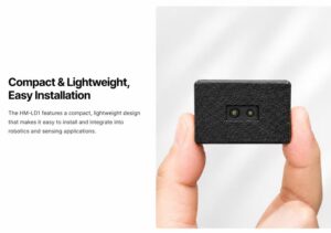
The DTOF Solid State LiDAR HM-LD1 is a compact dToF solid-state LiDAR module designed for real-time depth imaging and 3D point cloud output. It is suitable for robot navigation, obstacle avoidance, distance detection, UAV altitude hold, terrain following, smart inspection, robotic vision development, and embedded sensing systems.
Unlike consumer-only LiDAR implementations, HM-LD1 supports practical integration interfaces including UART, UDP, and UVC. That makes it easier to connect with PCs, Raspberry Pi, embedded Linux systems, flight controllers, development boards, and custom platforms. For engineers, that interface flexibility can reduce the amount of glue code and integration pain required to get meaningful data into the system.
Download the product brochure: DTOF SSL HM-LD1 Product Brochure
| Specification | DTOF SSL HM-LD1 |
|---|---|
| Technology | SPAD dToF solid-state LiDAR |
| Dimensions | 43.5 mm × 30 mm × 26.5 mm |
| Ranging Capability | Indoor: 0.5–25 m; Outdoor: 0.2–8 m |
| Ranging Accuracy | ±3 cm |
| Field of View | 60° horizontal × 45° vertical |
| Weight | 28 g |
| Resolution | 40 × 30 |
| Frame Rate | 10 fps |
| Interface | UART / UDP / UVC |
| Operating Temperature | -20°C to 60°C |
| Power Consumption | 1.2 W |
| Supported Development Platforms | SDKs for x86 Windows, x86 Linux, and ARM Linux |
| Typical Applications | Obstacle avoidance, distance detection, autonomous navigation, UAV altitude hold, terrain following, SLAM development, smart inspection, robotic vision, object recognition, intrusion monitoring, and volume measurement |
View Product Details & Pricing ➔
Why HM-LD1 Fits Affordable LiDAR Scanning Projects
HM-LD1 is a strong fit for affordable LiDAR scanning because it combines practical sensing performance with a compact form factor and straightforward integration. Its 28 g weight is useful for drones and small robots. Its 1.2 W power consumption supports battery-powered platforms. Its 60° by 45° field of view is appropriate for forward perception. Its 40 x 30 resolution and 10 fps frame rate are suitable for real-time depth awareness in many embedded applications.
The support for UART, UDP, and UVC also makes it flexible across different development styles. A microcontroller-based system may prefer UART. A Linux-based robot may use UDP. A PC-style development setup may benefit from UVC behavior. That gives developers practical options instead of locking them into one workflow.
Another important advantage is platform support. SDKs for x86 Windows, x86 Linux, and ARM Linux help reduce integration time. That matters. In real projects, software support can matter as much as raw measurement range. If you can integrate faster, validate sooner, and deploy with less friction, the total project cost becomes much easier to control.
Best-Fit Use Cases
HM-LD1 is well suited to AMR and AGV obstacle detection, UAV low-altitude perception, robotics research and development, Raspberry Pi and embedded Linux depth projects, smart inspection systems, security and zone monitoring, autonomous navigation support, and human presence detection.
These are exactly the kinds of applications where affordable LiDAR scanning creates the most value: tasks that need reliable distance sensing, real-time depth awareness, and compact integration without the overhead of a large survey platform.
Integration Workflow for Robots, Drones, and Embedded Platforms
Choosing a good LiDAR module is only part of the job. Integration determines whether the sensor performs well once the machine leaves the bench. A clean workflow reduces debugging time and improves the chance that the chosen module will be useful in both prototype and production stages.
Step 1: Define the Sensing Task
Start by defining what the system actually needs. Is the goal obstacle avoidance, mapping, altitude hold, object detection, docking, people detection, or presence sensing? What distances matter most? Is the platform indoor, outdoor, or mixed use? How fast is it moving? What happens if the sensor misses an object?
These questions help determine whether an affordable LiDAR sensor is suitable or whether a different class of sensor is required. Look, this step sounds basic, but it saves a lot of wasted money. A clear sensing requirement is better than a vague desire to “add LiDAR.”
Step 2: Match LiDAR Specs to the Environment
Bright sunlight, shadow transitions, reflective floors, black rubber, dust, fog, vibration, rain, glass, and angled surfaces all influence performance. A module that works beautifully in a lab may need extra validation in the field. If the platform is a drone, temperature drift and vibration deserve special attention. If the platform is a warehouse robot, reflective wrap, pallet geometry, and aisle layout may matter more.
Step 3: Choose the Right Interface
UART is often easiest for embedded control. UDP is useful for networked applications and software systems that already use Ethernet or IP-based communication. UVC is convenient for PC-style integration and some Linux-based workflows. The best interface is the one that fits the controller, compute board, and software architecture already planned for the product.
Do not underestimate this part. A sensor with the wrong interface can create more work than a sensor with slightly weaker specifications but clean software support.
Step 4: Mount and Calibrate the Sensor
Rigid mounting matters because even a good sensor can be undermined by poor alignment or vibration. The coordinate frame should be known, the field of view should not be blocked, and any protective window should be designed carefully. Cable strain relief is also important in mobile systems, since intermittent connections can cause more downtime than sensor limitations ever will.
In the shop, mechanical details are where many “sensor problems” actually come from. Loose brackets, vibrating mounts, dirty covers, and bad cable routing can all look like bad LiDAR data. Build the mount like it matters, because it does.
Step 5: Fuse LiDAR with Other Sensors
LiDAR is powerful, but sensor fusion often produces the best result. IMUs help with motion estimation. Wheel odometry helps with local displacement in ground robots. GNSS or RTK can support outdoor localization. Cameras can add semantic interpretation. The best affordable LiDAR scanning systems are usually part of a broader sensing stack rather than a standalone solution.
Step 6: Validate with Real-World Testing
Testing should include sunlight transitions, black and white targets, human legs, small obstacles, inclines, corridors, open spaces, reflective surfaces, moving objects, and the exact operating conditions expected in deployment. For drones, this means validating descent, landing, and terrain following behavior. For robots, it means validating hallways, shelves, turns, intersections, docking points, and dynamic obstacles.
Reliable engineering comes from realistic testing, not spec sheet assumptions. If the sensor is going into a warehouse, test it in a warehouse. If it is going onto a drone, test vibration, sunlight, and altitude behavior. Bench testing is useful, but it is not the finish line.
Affordable LiDAR Selection Checklist
Before choosing a module, move through a technical checklist. This keeps the team from focusing on one attractive number while ignoring practical fit.
- ✅ Range: Confirm indoor and outdoor ranging distance separately.
- ✅ Accuracy: Check whether the accuracy is suitable for obstacle avoidance, navigation, or measurement.
- ✅ FOV: Make sure horizontal and vertical coverage match your mounting position.
- ✅ Resolution: Confirm whether the point density supports your detection task.
- ✅ Frame rate: Match update speed to robot or drone motion speed.
- ✅ Interface: Choose UART, UDP, UVC, or another interface based on your controller and software stack.
- ✅ Power: Verify power draw for battery-powered platforms.
- ✅ Weight: Critical for drones and compact mobile robots.
- ✅ SDK support: Look for Windows, Linux, and ARM Linux compatibility if you are developing on PC, Raspberry Pi, or embedded platforms.
- ✅ Environmental limits: Check sunlight, temperature, dust, vibration, and surface reflectivity conditions.
- ✅ Mechanical integration: Confirm dimensions, mounting, enclosure needs, cable routing, and protection window design.
- ✅ Supplier support: Choose a supplier that can provide integration guidance, customization, and stable supply.
Quick Recommendation
For compact robots, UAVs, and embedded vision systems, a lightweight solid-state dToF LiDAR with real-time depth output, point cloud data, stable embedded interfaces, and SDK support is often the best balance between affordability and engineering usability.
That is the core idea behind truly affordable LiDAR scanning: not the lowest sticker price, but the lowest practical system cost for a successful deployment. If the sensor helps the machine sense reliably, integrate cleanly, and ship on schedule, that is a better bargain than a cheaper module that creates weeks of engineering pain.
Got tired of bulky LiDAR setups for simple depth tasks
FAQ: Affordable LiDAR Scanning
Is affordable LiDAR scanning good enough compared with iPhone LiDAR or expensive survey scanners?
What is the cheapest LiDAR sensor that is still effective for indoor SLAM, localization, and obstacle avoidance?
Can low-cost LiDAR scan outdoors, under vegetation, or from drones on a budget?
Final Thoughts: Choose Affordable LiDAR by Engineering Fit, Not Price Alone
Affordable LiDAR scanning is most valuable when the sensor is selected according to the real engineering task. For robots, drones, SLAM development, inspection systems, security systems, and embedded vision products, the best budget LiDAR is not simply the cheapest module available. It is the sensor that provides the right range, accuracy, field of view, frame rate, output data, interface compatibility, platform support, size, weight, power consumption, and supplier support for the target application.
A compact dToF solid-state module such as the DTOF Solid State LiDAR HM-LD1 demonstrates how affordable LiDAR can deliver practical depth sensing in a small, lightweight package. With indoor and outdoor ranging capability, ±3 cm accuracy, 60° x 45° FOV, 40 x 30 resolution, 10 fps frame rate, UART/UDP/UVC interfaces, 1.2 W power consumption, and SDK support for x86 Windows, x86 Linux, and ARM Linux, it is well suited for robotics, UAV, smart inspection, and embedded perception development.
Look at the whole system before making the purchase. Check the mounting, the software stack, the environment, the control loop, the required range, and the failure modes. In the shop, the winning sensor is rarely the one with the loudest spec sheet. It is the one that works consistently, integrates cleanly, and helps the machine do its job.
Explore the module here: DTOF Solid State LiDAR HM-LD1.
📚 References & Further Reading
- Industry Standard: Onsemi
- Related Guide: iToF vs dToF LiDAR technology






