


DJI Drones with Obstacle Avoidance: Best Models, Real Limits, and Sensor Upgrade Options
DJI drones with obstacle avoidance are often sold as safer, smarter, and easier to fly. That is partly true, but here’s the deal: not all obstacle avoidance systems behave the same way in the real world. A Mini-series drone with limited directional sensing is not in the same league as a higher-end Mavic, Air, or enterprise aircraft with broader multi-directional or omnidirectional sensing. The label sounds simple. The engineering underneath is not.
Obstacle avoidance is a helper, not a force field. Even the best DJI obstacle sensing can struggle with thin branches, power lines, glass, reflective buildings, low light, fast sideways motion, snow, water, and messy industrial environments. In the shop, we call this the difference between a feature that works well in a clean demo and a perception system that survives field conditions.
This guide breaks down the main DJI drone obstacle avoidance categories, explains how vision and infrared sensing work, and shows where those systems fail during real flight. It is written for buyers, drone pilots, inspection teams, robotics developers, and anyone trying to separate useful safety features from marketing language.
For UAV developers, robotics teams, and industrial inspection users, we will also look at sensor upgrade options. That includes compact dToF LiDAR modules such as the DTOF Solid State LiDAR HM-LD1, which can provide real-time depth images and point cloud data for custom obstacle detection, navigation, and autonomous perception systems.
Table of Contents
- 👉 Quick Answer: Which DJI Drones Have Obstacle Avoidance?
- 👉 How DJI Obstacle Avoidance Works
- 👉 Best DJI Drones with Obstacle Avoidance by Use Case
- 👉 Obstacle Avoidance Directions Explained
- 👉 Real-World Limits of DJI Obstacle Avoidance
- 👉 Obstacle Avoidance During Return-to-Home and Follow-Me Flight
- 👉 Industrial and Commercial UAV Considerations
- 👉 Sensor Upgrade Options for Stronger Obstacle Detection
- 👉 DTOF Solid State LiDAR HM-LD1 for UAV Perception
- 👉 Selection Checklist: Which Drone or Sensor Setup Is Right?
- 👉 FAQ: DJI Drones with Obstacle Avoidance
Quick Answer: Which DJI Drones Have Obstacle Avoidance?
Many DJI drones have some type of obstacle sensing, but the level of protection changes a lot by model class, aircraft generation, flight mode, firmware, and sensor direction. Higher-end DJI Mavic, Air, and enterprise platforms generally offer stronger coverage than entry-level models. Some lightweight drones include useful forward, backward, and downward sensing, while other small drones rely mostly on downward vision or simpler safety features. So when someone says dji drones with obstacle avoidance, do not assume that means one universal capability.
The smarter buying approach is to match sensor coverage to how the drone will actually move. A beginner practicing slow forward flight needs different coverage than a filmmaker doing reverse pull-back shots, a creator orbiting a subject, a roof inspector flying near gutters, or a robotics team testing low-altitude autonomy. Obstacle avoidance works best when the sensor direction matches the direction of travel and the scene has enough light, texture, and contrast for the system to estimate depth.
Fast Comparison by User Type
- ✅ Beginners: Look for at least forward, backward, and downward sensing where possible. These directions help reduce common mistakes such as flying into walls, trees, fences, roofs, and parked vehicles.
- ✅ Travel creators: Prioritize lightweight models with multi-directional sensing, stable GPS, reliable Return-to-Home, and intelligent tracking features for beaches, cliffs, forests, cities, and scenic routes.
- ✅ Cinematic pilots: Look for advanced pilot assistance, smooth braking behavior, strong subject tracking, and lateral sensing if orbit shots or side tracking are part of your workflow.
- ✅ Inspectors and mapping teams: Prioritize enterprise platforms, payload compatibility, RTK workflows, mission planning, low-speed control, and the option to integrate external perception sensors.
- ⚙️ Developers and robotics teams: Consider SDK access, companion computers, external LiDAR, depth cameras, embedded Linux compatibility, raw point clouds, and custom path-planning logic.
Important Warning
Obstacle avoidance is not crash-proofing. It is a perception-assistance system that can reduce collision risk, but it cannot guarantee safety in every environment. A drone may detect a large wall yet miss a thin branch. It may perform well in daylight but struggle at dusk. It may brake in normal mode but reduce or disable avoidance behavior in sport mode. Pilots should maintain visual line of sight, set a safe Return-to-Home altitude, read the aircraft manual, and treat obstacle sensing as one layer of safety rather than the main safety plan.
How DJI Obstacle Avoidance Works
DJI obstacle avoidance systems usually combine sensor hardware, onboard processing, flight-control logic, and intelligent flight modes. The goal is straightforward: help the drone estimate nearby obstacles and decide whether to warn the pilot, slow down, stop, hover, or route around an object. The exact behavior depends on the model and selected flight mode.
In normal photo and video work, obstacle avoidance can make flying feel more controlled and less stressful. In engineering work, though, it is important to understand that consumer obstacle avoidance is not the same thing as an open robotics perception stack. You may get good pilot-assist behavior, but you may not get raw depth data, point clouds, direct control over avoidance zones, or the ability to plug the sensing data into your own autonomy software.
Vision Sensors
Many DJI drones use vision sensors to estimate depth. A common method is stereo vision, where two cameras look at the same scene from slightly different positions. The system compares image features between the two views and estimates distance in a way that is loosely similar to how human eyes judge depth.
When there is enough light and enough visual texture, stereo vision can work very well for common obstacles such as buildings, walls, terrain, tree trunks, people, and large structures. In open daylight, it can be a very useful safety tool. But vision has limits. Blank walls, snow, water, glass, mirrors, low-light scenes, and low-texture surfaces can reduce depth quality. Thin obstacles are especially difficult. A power line against a bright sky, a bare branch in front of dark foliage, or a fishing line near water may be obvious to a human and still hard for the drone to classify in time.
Infrared and Downward Sensors
Some DJI drones use infrared sensing and downward vision for low-altitude positioning, landing protection, and hover stability. Downward sensors are particularly useful when GPS is weak, such as indoors, under bridges, near tall structures, or close to walls. They help the aircraft hold position over textured ground and support safer landing behavior.
But downward sensing is not the same as full obstacle avoidance. A drone with only downward sensing can still fly forward into a tree, backward into a wall, or sideways into a pole. In the shop, we would call downward sensing a stability and landing feature first, and a collision-prevention feature only in a limited vertical sense.
APAS and Flight Path Planning
APAS, or Advanced Pilot Assistance Systems, is DJI’s obstacle-aware flight assistance on supported models. Depending on the aircraft and mode, APAS may help the drone brake, bypass obstacles, or pick a smoother path around them. This is useful for active filming, subject tracking, and general confidence, but it is not industrial-grade autonomous navigation.
APAS behavior can vary by model, firmware, lighting, speed, sensing direction, and flight mode. It may be unavailable or reduced in aggressive modes. It may also struggle around thin objects, glass, reflective surfaces, low-contrast scenes, and fast movement. If you are comparing DJI drones with obstacle avoidance, always read the model-specific documentation instead of assuming every DJI obstacle system behaves the same way.
For a deeper technical explanation of laser-based ranging and how it differs from camera-based depth estimation, see our guide: LiDAR: What Is It and How LiDAR Works.
Best DJI Drones with Obstacle Avoidance by Use Case
The “best” DJI drone with obstacle avoidance depends on the job. A beginner needs forgiveness and simple controls. A travel creator needs portability and tracking. A commercial inspector needs predictable low-speed control and reliable spacing near structures. A developer may care less about polished consumer modes and more about raw data, companion computers, and external sensor integration.
Best for Beginners
Beginners should not automatically buy the cheapest drone. Entry-level aircraft are tempting because they lower the upfront cost, but some lower-cost models have limited obstacle sensing. If you are learning near trees, buildings, fences, vehicles, or people, obstacle avoidance can be worth the extra money. At minimum, look for stable GPS positioning, reliable Return-to-Home, downward vision, and forward obstacle sensing if the budget allows.
Forward sensing helps because new pilots often fly toward objects while watching the camera feed instead of the aircraft. Backward sensing helps because many beginner cinematic shots involve backing away from a subject. Downward sensing helps with landing and hover stability. More directions usually mean a more forgiving aircraft, but no drone should be treated as immune to crashes.
Best for Travel and Content Creation
Travel creators usually want a drone that is light, quick to launch, and capable of smooth automated shots in unfamiliar locations. Obstacle sensing helps around cliffs, buildings, beaches, forests, monuments, boats, mountain roads, and tight launch areas. It is especially useful during automated camera moves, when the pilot may be focused on framing instead of constantly checking every direction around the aircraft.
For travel work, multi-directional sensing is more useful than simple downward positioning. If you plan to orbit a subject, sideways sensing matters. If you film hiking trails or cycling routes, forward and backward sensing matter. If you fly under trees, bridges, or rock overhangs, upward awareness can also help. The safest travel workflow combines good obstacle sensing with conservative route planning, clear launch areas, battery margin, and avoidance of known hazards such as wires and crowded spaces.
Best for ActiveTrack and Follow-Me
Obstacle avoidance becomes more important when using ActiveTrack, Follow-Me style functions, or subject-tracking modes. During tracking, the drone may move forward, backward, sideways, diagonally, or in an arc while the pilot is not manually controlling every movement. If the drone lacks sensing in the direction of travel, it can still collide even if it has strong sensors in another direction.
Following a cyclist through trees requires more than recognizing the cyclist. The aircraft also needs to understand trunks, branches, poles, uneven terrain, and changing paths. Orbiting a car near street signs or power poles requires lateral awareness. Tracking a runner on a forest trail exposes the drone to thin branches and quick direction changes. For serious tracking, choose a model class known for stronger multi-directional sensing and verify that obstacle avoidance works in the specific tracking mode you plan to use.
Best for Professional Inspection
Professional inspection is a different animal from casual aerial photography. Inspection drones often work near bridges, towers, dams, roofs, cranes, wind turbines, solar farms, warehouses, tunnels, and industrial plants. In these places, the aircraft may need to approach a structure intentionally while holding a precise standoff distance. A consumer obstacle system may see the inspection target as something to avoid, while the inspection job requires controlled proximity.
For inspection work, a strong setup may include an enterprise UAV platform, mission planning software, RTK or GNSS positioning, visual payloads, thermal cameras, LiDAR, radar, or depth sensors. Professional teams may also need repeatable flight paths, raw sensor data, and software access for reporting and automation. For users evaluating high-precision positioning and geospatial workflows, external references such as CHC Navigation can be useful for understanding professional GNSS, RTK, and mapping ecosystems.
Obstacle Avoidance Directions Explained
One of the biggest misunderstandings about DJI obstacle avoidance is the assumption that “has obstacle avoidance” means “can avoid obstacles everywhere.” That is not how these systems work. Obstacle sensing is directional. A drone may detect obstacles below it but not beside it. Another may sense forward and backward but not upward. A more advanced drone may advertise omnidirectional sensing, but even then, it can still have blind spots, minimum range limits, maximum range limits, mode restrictions, and environmental weaknesses.
Downward Sensing
Downward sensing is commonly used for landing protection, hover stability, indoor positioning, and low-altitude ground awareness. It helps the drone understand the surface beneath it, especially when GPS is weak or unavailable. It can improve stability over textured floors or ground surfaces and help reduce landing risk during descent.
But downward sensing does not prevent forward crashes. A drone with only downward sensors may hover nicely and land smoothly while still being able to fly straight into a tree, window, wall, or person. Treat downward sensing as a stability and landing feature, not complete collision avoidance.
Forward Sensing
Forward obstacle sensing is one of the most important directions for beginners and general outdoor flying. It helps when the drone is flying straight ahead, approaching a subject, following a route, or moving through open space. Depending on the model and mode, forward sensing may warn the pilot, brake the aircraft, or help route around an obstacle.
The limitations matter. Forward vision may miss wires, bare branches, fishing lines, small cables, and objects with poor contrast. Speed also matters because the drone needs time to detect, process, and stop. Lighting and texture matter too. A pilot should never intentionally fly toward an object just to test the system.
Backward Sensing
Backward sensing is valuable for reveal shots, reverse tracking, and cinematic pull-backs. A lot of drone crashes happen when pilots fly backward while watching the camera view. Since the main camera usually faces forward, the pilot may not notice a tree, pole, wall, or roofline behind the aircraft.
A drone with backward obstacle sensing can reduce this risk by detecting larger obstacles behind it. This is especially useful for creators filming people, houses, landscapes, vehicles, and moving subjects. Still, backward sensors have the same basic weaknesses as other vision systems: thin objects, low light, reflective surfaces, and high-speed movement can reduce reliability.
Sideways and Lateral Sensing
Sideways sensing is critical for orbit shots, parallel tracking, and lateral cinematic movement. A drone without side sensors can crash during sideways flight even if it has good forward and backward obstacle sensing. This is common when filming a person walking, a vehicle moving along a road, or a landscape reveal that requires the drone to slide sideways.
Lateral sensing also matters in industrial inspection. Flying beside a wall, storage rack, bridge structure, or tower requires awareness of side distance. Without lateral sensors or external perception modules, the pilot must manually maintain spacing. In tight environments, a small positioning error can be enough to contact the structure.
Upward Sensing
Upward sensing is useful near ceilings, bridges, tree canopies, warehouses, indoor structures, and overhead equipment. It can help reduce risk when climbing under obstacles or flying in environments where hazards are above the aircraft rather than in front of it. For inspection teams, upward sensing may matter around bridge decks, industrial piping, storage racks, and roof structures.
Not every drone has upward obstacle sensing. Even when it is present, it should be treated as support, not a guarantee. Overhead wires, mesh, pipes, and beams may still be difficult to detect. Indoor and underside inspection work often requires conservative flying and sometimes additional sensing.
Omnidirectional Sensing
Omnidirectional obstacle sensing generally means broad multi-directional coverage across forward, backward, lateral, upward, and downward directions. It does not mean perfect spherical perception. Coverage depends on sensor placement, lens angles, software, flight mode, aircraft attitude, and environmental conditions.
For most pilots, omnidirectional sensing is the most confidence-building category because it supports more types of movement. For developers and industrial users, however, consumer omnidirectional sensing may still be too closed or too behavior-focused. If you need raw depth maps, point clouds, custom obstacle zones, or application-specific autonomy, external sensors may be needed.
Real-World Limits of DJI Obstacle Avoidance
Obstacle avoidance is most useful when pilots understand its limits. Many crashes happen not because the drone has no sensing, but because the pilot expects too much from the system. Marketing videos usually show large, visible, well-lit obstacles. Real job sites and outdoor locations contain wires, branches, transparent surfaces, low-contrast backgrounds, dust, rain, glare, shadows, moving subjects, and complex geometry.
Thin Branches, Wires, and Cables
Thin objects are among the hardest obstacles for many drone systems. Power lines, fishing lines, bare branches, fence wires, and small cables may occupy only a tiny part of the camera image. They may blend into the background, appear at an unfavorable angle, or move in the wind. A human may see them clearly, while the drone may not classify them reliably or early enough to stop.
This is why flying near power lines is always high risk. Even if a drone can detect some wires in ideal conditions, pilots should assume wires are dangerous and avoid them. Industrial powerline inspection requires specialized procedures, experienced pilots, careful mission planning, and often additional sensing or imaging systems.
Glass, Mirrors, and Reflective Surfaces
Glass and reflective surfaces can confuse vision systems because they may appear transparent, invisible, or visually misleading. A glass wall may reflect the scene behind the drone and create bad depth estimates. Mirrors can create false features. Shiny metal, wet surfaces, and reflective building facades can also cause trouble.
For urban flights and building inspections, glass is a serious concern. A drone may not interpret a window as a solid obstacle the way it detects a textured wall. Maintain conservative distance from glass structures and do not rely on obstacle avoidance to protect the aircraft near reflective architecture.
Low Light and Night Flight
Vision-based obstacle avoidance usually needs adequate light. In dim scenes, image noise increases and visual feature matching becomes less reliable. Some drones may warn that vision systems are unavailable or reduced. Others may continue operating with lower confidence. Downward infrared sensors may help in certain close-range landing situations, but they do not provide full environmental awareness.
Night flight increases risk. If local regulations allow night operations, pilots should verify sensor status, use proper lighting, avoid obstacles, and plan flight paths carefully. Industrial teams working in darkness often evaluate active sensing technologies such as LiDAR or radar because these sensors do not rely only on ambient visible light.
Fast Flight and Sport Mode
At higher speeds, obstacle avoidance becomes harder because the drone needs more stopping distance and faster processing. Even if the sensor detects an obstacle, the aircraft may not have enough room to brake smoothly. In sport or aggressive flight modes, obstacle avoidance may be reduced or disabled to allow faster response and higher speed.
If you are flying near objects, slow down. For engineering teams designing autonomous UAV behavior, sensor range, frame rate, processing latency, braking distance, and control-loop response must be considered together. A sensor that looks good on paper may not be enough if the aircraft is moving too fast for the available detection range.
Repetitive Textures and Featureless Surfaces
Stereo vision needs visual features. Smooth walls, snow fields, water, asphalt, sand, and uniform floors may not provide enough texture for reliable depth estimation. Repetitive patterns can also confuse matching algorithms because many parts of the image look similar.
Water is especially difficult because it reflects the sky, moves continuously, and lacks stable texture. Snow can be bright and featureless. Smooth warehouse floors may not provide strong visual cues. In these environments, additional sensing such as LiDAR, radar, or structured illumination may improve local perception, depending on the mission.
Weather and Environmental Conditions
Rain, fog, dust, smoke, direct sunlight, and strong backlighting can all affect sensors. Water droplets may obscure lenses. Fog and dust can scatter light. Strong sun can reduce contrast or create glare. Smoke can reduce visibility. Industrial users need to take these environmental factors seriously because mission safety and repeatability matter.
For another practical discussion of compact depth sensing and consumer awareness of LiDAR, see: LiDAR Scanner iPhone. Smartphone LiDAR and UAV perception modules are different, but the topic helps explain why direct depth sensing is useful when visual appearance alone is not enough.
Obstacle Avoidance During Return-to-Home and Follow-Me Flight
Return-to-Home and subject tracking are two common reasons people search for DJI drones with obstacle avoidance. These features are useful, but they are often misunderstood. A drone returning home or following a subject may not detect every obstacle. Behavior depends on sensor directions, RTH altitude, GPS accuracy, lighting, obstacle type, flight mode, and model-specific software.
Return-to-Home Is Not Automatically Obstacle-Proof
Return-to-Home is designed to help bring the aircraft back to a recorded home point. It is not a guarantee of obstacle-free flight. If the RTH altitude is too low, the drone may encounter trees, buildings, poles, wires, or terrain. If the drone has limited directional sensing, it may not detect obstacles in every direction. If lighting is poor or the obstacle is thin, the aircraft may not respond as expected.
The safest RTH practice is to set the return altitude above nearby trees, buildings, and structures whenever possible. Pilots should keep the home point updated, monitor battery reserve, maintain visual line of sight, and understand the aircraft’s RTH settings. Obstacle avoidance should be a backup layer, not the main RTH safety strategy.
Follow-Me and ActiveTrack Risks
Follow-Me and ActiveTrack-style functions can create complex flight paths. The drone may move laterally, backward, diagonally, or in an arc while tracking the subject. If the aircraft lacks sensing in the movement direction, it may collide with a nearby obstacle. Even with strong sensing, thin branches, wires, low light, and fast movement can still cause problems.
Examples include following a cyclist through trees, tracking a runner on a forest trail, orbiting a car near signs, or flying beside a boat near docks. In each case, the subject may be easy to track, but the environment may not be easy to avoid. Test tracking modes in open spaces first, then work into more complex areas only when you understand the aircraft’s behavior.
Terrain Following and Low-Altitude Autonomy
Consumer drone obstacle avoidance is not the same as industrial terrain following. Terrain following requires reliable altitude or distance measurement, predictable control behavior, and often dedicated downward range sensing. Low-altitude autonomous flight over uneven ground, warehouses, bridges, or industrial structures may require LiDAR, depth cameras, radar, RTK, IMU fusion, and custom flight-control logic.
For robotics and UAV development, the requirement is often not simply “avoid obstacles.” The real requirement is access to reliable sensor data and the ability to make application-specific decisions. That is where compact dToF LiDAR modules, embedded computers, and multi-sensor fusion become relevant.
Industrial and Commercial UAV Considerations
Industrial UAV users have different expectations from recreational pilots. A photographer wants fewer crashes and smoother video. An inspection team may need measurable distance to a bridge girder. A warehouse operator may need indoor positioning near racks. A research lab may need raw point cloud data. A robotics developer may need a sensor that communicates with Linux, a flight controller, or a companion computer.
Inspection Requires More Than Collision Avoidance
Industrial inspections often require the UAV to approach structures deliberately. In these workflows, the drone must distinguish between an obstacle to avoid and a target to inspect. A bridge, dam, tower, or roof may be the object of interest, not simply a hazard. The challenge is to maintain a safe, repeatable distance while collecting useful data.
Use cases include bridge inspection, dam inspection, powerline inspection, cell tower inspection, warehouse inventory, tunnel inspection, roof assessment, and industrial plant monitoring. In each case, the sensing strategy depends on environment, distance, payload, lighting, and flight path. Built-in avoidance can help prevent accidental contact, but it may not provide the raw data or control flexibility needed for automation.
Why DJI Built-In Sensing May Not Be Enough
DJI’s onboard obstacle avoidance is generally designed to support safe flight and pilot assistance. It is not always designed to expose raw depth data for custom robotics applications. Developers may need depth maps, point clouds, SDK access, ROS integration, embedded platform compatibility, adjustable sensing zones, custom path planning, and multi-sensor fusion.
If an application requires custom autonomy, the development team may need external sensors mounted to the UAV or test platform. These sensors may feed a companion computer that processes data independently. Depending on the aircraft and software ecosystem, the external system may monitor the environment, collect inspection data, support operator decisions, or contribute to autonomy research.
RTK, GNSS, and Perception Fusion
Professional UAV systems often combine positioning and perception. RTK can improve global position accuracy, while LiDAR or depth sensing improves local environmental awareness. GNSS and RTK tell the drone where it is in the world. LiDAR, cameras, and radar help the drone understand what is nearby. IMUs provide motion and attitude data. Together, these streams support more reliable navigation and mapping.
For related UAV positioning hardware, see: HM-D20: The Helical Antenna RTK Drone Module. Professional surveying and navigation ecosystems, such as those from CHC Navigation, also show how positioning, mapping, and perception technologies can work together in high-accuracy field applications.
Sensor Upgrade Options for Stronger Obstacle Detection
When DJI built-in obstacle sensing is not enough, developers and industrial teams may evaluate external sensors. The right choice depends on the mission. A slow indoor drone may need short-range dense depth. A fast outdoor UAV may need longer detection range. A mapping drone may prioritize positioning accuracy. A close inspection platform may prioritize reliable standoff distance and side-facing perception.
dToF LiDAR Modules
Direct Time-of-Flight LiDAR measures distance by emitting light pulses and measuring the return time. A dToF module can provide direct range measurements and may output depth images or point cloud data depending on the design. For UAV applications, dToF LiDAR can be useful for close-range obstacle detection, altitude sensing, terrain following, indoor navigation, and robotics perception.
The benefits include real-time depth information, compact integration, embedded-system compatibility, and point cloud support. Limitations include target reflectivity, field of view, range, frame rate, power, optical conditions, and mechanical integration. Outdoor sunlight can reduce effective distance for some optical sensors, so developers must test under real mission conditions rather than relying only on ideal specifications.
Stereo Depth Cameras
Stereo depth cameras estimate distance from two or more camera views. They can provide dense depth maps and visual context, making them useful for robotics and AI perception. However, stereo depth depends heavily on light and texture. Blank walls, darkness, glass, reflective materials, snow, and water can reduce reliability.
Stereo systems can be powerful when paired with good compute resources and robust software, but they require careful calibration and environmental testing. For drone use, weight, processing load, vibration, exposure control, and field of view must be considered.
Ultrasonic Sensors
Ultrasonic sensors are low-cost and useful for close-range distance measurement. They can help with basic altitude sensing or simple obstacle detection in controlled environments. However, their use cases are limited. Wind, soft materials, angled surfaces, propeller noise, and narrow detection cones can reduce performance.
Ultrasonic sensing is usually not the best choice for complex UAV autonomy, but it may still be useful in simple low-speed robotics projects or as one layer in a broader sensor system.
Radar Sensors
Radar sensors can operate in poor visibility and may detect objects in dust, fog, smoke, or darkness. This makes radar attractive for some industrial and safety-critical applications. However, radar often has lower spatial resolution than LiDAR or vision sensors, and signal processing can be more complex.
For UAV obstacle detection, radar may be useful when optical sensors are limited by environmental conditions. In many systems, radar works best as part of a multi-sensor strategy rather than a standalone solution.
Multi-Sensor Fusion
The strongest industrial systems often combine several sensors. GNSS or RTK provides global location. IMUs provide attitude and motion. Vision provides semantic context. LiDAR provides depth and obstacle distance. Barometers and rangefinders help with altitude. Onboard compute connects data streams and supports path planning.
Multi-sensor fusion is not just bolting on more hardware. It requires synchronization, calibration, software architecture, latency management, power budgeting, vibration control, and environmental validation. For UAV developers, the goal is to create a reliable perception system matched to mission speed, obstacle type, safety requirements, and integration constraints.
DTOF Solid State LiDAR HM-LD1 for UAV Perception
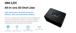
The DTOF Solid State LiDAR HM-LD1 is a compact dToF LiDAR module designed for depth sensing, obstacle avoidance, distance detection, autonomous navigation, robotic vision development, and UAV-related perception applications. Its small form factor and 28 g weight make it relevant for drones and compact robots where payload weight affects flight time, battery life, mechanical layout, and integration space.
The HM-LD1 is based on SPAD dToF technology and can output real-time depth images and 3D point cloud data. It supports UART, UDP, and UVC interfaces, allowing integration with PCs, Raspberry Pi, flight controllers, and embedded platforms. It is not positioned as a consumer plug-and-play DJI accessory. Instead, it is best understood as a perception module for developers, integrators, UAV system designers, robotics teams, and research projects that require access to depth data rather than only closed pilot-assist behavior.
Product page: DTOF Solid State LiDAR HM-LD1
Download DTOF SSL HM-LD1 Product Brochure
DTOF Solid State LiDAR HM-LD1 Specifications
| Specification | DTOF Solid State LiDAR HM-LD1 |
|---|---|
| Technology | Solid-state LiDAR based on SPAD dToF technology |
| Dimensions | 43.5 mm × 30 mm × 26.5 mm |
| Ranging Capability | Indoor: 0.5–25 m; Outdoor: 0.2–8 m |
| Ranging Accuracy | ±3 cm |
| Field of View | 60° horizontal × 45° vertical |
| Resolution | 40 × 30 |
| Frame Rate | 10 fps |
| Interfaces | UART / UDP / UVC |
| Operating Temperature | -20 ℃ to 60 ℃ |
| Power Consumption | 1.2 W |
| Weight | 28 g |
| Output Data | Depth image and 3D point cloud data |
| Development Support | SDKs for x86 Windows, x86 Linux, and ARM Linux |
| Typical Applications | UAV altitude hold, terrain following, obstacle avoidance, robot navigation, SLAM, smart inspection, object detection, zone intrusion monitoring |
Why HM-LD1 Matters for Drone Developers
The HM-LD1 matters because it addresses a real gap between consumer obstacle avoidance and developer-accessible perception. Many DJI drones provide useful avoidance behavior, but developers may not be able to access the raw data needed for custom autonomy. A compact module such as HM-LD1 can provide depth images and 3D point cloud data for external processing, testing, and integration into custom robotic systems.
Its weight of 28 g is important for UAVs because payload mass affects flight time and handling. Its 1.2 W power consumption is also relevant for battery-powered platforms. The specified ranging capability of indoor 0.5–25 m and outdoor 0.2–8 m makes it suitable for close-range perception tasks, particularly when the drone is moving slowly or operating near structures. Its 60° horizontal by 45° vertical field of view and 10 fps frame rate should be considered during system design, especially when matching sensor coverage to drone speed and stopping distance.
The interface options are practical. UART can be useful for embedded control and simpler data links. UDP can support networked data transmission. UVC can simplify camera-like integration in some systems. SDK support for x86 Windows, x86 Linux, and ARM Linux helps teams develop across PCs, Raspberry Pi-class devices, and embedded Linux platforms.
Example UAV Use Cases
- ⚙️ Front-facing close-range obstacle detection for experimental UAV platforms
- ⚙️ Downward terrain following and low-altitude distance measurement
- ⚙️ Altitude hold assistance in controlled environments
- ⚙️ Indoor drone navigation where GPS is unavailable
- ⚙️ Warehouse drone perception near racks, walls, and aisles
- ⚙️ Bridge, expressway, and dam inspection distance sensing
- ⚙️ Robotics research platforms requiring depth maps and point clouds
- ⚙️ UAV autonomy prototyping with embedded Linux or Raspberry Pi
- ⚙️ Multi-sensor fusion with RTK, IMU, visual cameras, and onboard compute
For commercial inspection teams, the value is not simply that LiDAR can detect obstacles. The more important point is that a module like HM-LD1 can provide measurable depth data that developers can process according to mission needs. A bridge inspection workflow may need to maintain a standoff distance. A warehouse drone may need to detect shelving zones. A research platform may need point clouds for SLAM experiments. These are different problems from consumer crash prevention.
View Product Details & Pricing ➔
Selection Checklist: Which Drone or Sensor Setup Is Right?
Choosing between a DJI drone with built-in obstacle avoidance and a custom sensor setup depends on whether you need pilot assistance or engineering-level perception. Many pilots only need safer flying, smoother tracking, and better Return-to-Home confidence. Developers may need raw depth data, field calibration, embedded processing, and algorithm control.
Choose a DJI Drone with Built-In Obstacle Avoidance If…
- ✅ You are a beginner who wants extra crash protection.
- ✅ You mostly fly outdoors in daylight.
- ✅ You want safer Return-to-Home and subject tracking features.
- ✅ You are doing photography or video rather than custom autonomy.
- ✅ You do not need raw sensor data.
- ✅ You are satisfied with DJI’s built-in braking, warning, or bypass behavior.
- ✅ You prefer a ready-to-fly system with minimal integration work.
Consider External Sensors If…
- ⚙️ You are building an autonomous UAV or robotics platform.
- ⚙️ You need raw depth data, depth images, or point clouds.
- ⚙️ You need custom path planning or custom detection zones.
- ⚙️ You are flying indoors or near complex structures.
- ⚙️ You need terrain following or altitude measurement beyond basic pilot assistance.
- ⚙️ You are working on robotics, SLAM, smart inspection, or research systems.
- ⚙️ You need integration with embedded Linux, Raspberry Pi, a flight controller, or a companion computer.
Practical Buying Questions
- ⚙️ Does the drone have sensing in the direction it will move?
- ⚙️ Does obstacle avoidance work in the flight mode you plan to use?
- ⚙️ Will you fly near wires, branches, glass, reflective materials, or industrial structures?
- ⚙️ Do you need raw depth data or just pilot-assist avoidance?
- ⚙️ Is your environment bright, dark, dusty, reflective, repetitive, or low contrast?
- ⚙️ Do you need RTK, LiDAR, SDK access, or external compute?
- ⚙️ Is payload weight a constraint?
- ⚙️ Can your system provide enough power for additional sensors?
- ⚙️ Do you need UART, UDP, UVC, ROS, Linux, or ARM compatibility?
- ⚙️ Will the drone operate manually, semi-autonomously, or fully autonomously?
For most recreational pilots, the best solution is a DJI drone with the strongest obstacle sensing they can reasonably afford. For developers, the best solution may be a layered system: a stable UAV platform, a companion computer, positioning hardware, and one or more perception sensors such as dToF LiDAR. The important engineering principle is simple: design the sensing system around the mission, not around a marketing phrase.
FAQ: DJI Drones with Obstacle Avoidance
Which DJI drone has the best obstacle avoidance?
Is obstacle avoidance really worth the extra cost for beginners or poor pilots?
Do DJI Mini drones avoid obstacles during Return-to-Home or follow-me flight?
Can DJI obstacle avoidance detect power lines?
Does obstacle avoidance work at night?
What is the difference between obstacle avoidance and obstacle sensing?
Is LiDAR better than DJI vision obstacle avoidance?
Can I add obstacle avoidance sensors to a DJI drone?
What sensor range is enough for drone obstacle avoidance?
What is the best obstacle avoidance setup for industrial drones?
Download HM-LD1 Product Brochure
📚 References & Further Reading
- Industry Standard: CHC Navigation
- Related Guide: LiDAR: What Is It and How LiDAR Works
- Related Guide: LiDAR Scanner iPhone
- Related Guide: HM-D20: The Helical Antenna RTK Drone Module
- Product Resource: DTOF Solid State LiDAR HM-LD1






