


Industrial drone teams figure this out pretty quickly: a camera only gets you so far. When the mission involves low-texture floors, repetitive warehouse aisles, night work, vegetation, elevated structures, uneven terrain, or close-in obstacle detection, a modern industrial lidar drone setup needs direct 3D distance data. Here’s the deal: the real engineering job is not just “add LiDAR.” It is balancing payload weight, power draw, sensing range, accuracy, field of view, data format, SDK support, and the day-to-day hassle of getting the sensor to play nicely with a real UAV stack.
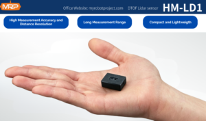
For a lot of inspection, autonomy, and compact mapping projects, a lightweight dToF solid-state LiDAR module makes a whole lot more sense than a bulky survey-grade payload. The DTOF Solid state LiDAR HM-LD1 is a good example. It weighs only 28 g, gives you a 60° horizontal by 45° vertical field of view, supports ±3 cm ranging accuracy, and offers UART, UDP, and UVC interfaces for embedded development. In practical terms, that makes it useful for small UAVs, indoor MAVs, robotic platforms, inspection prototypes, and teams moving from bench testing to something they can actually deploy.
Table of Contents
- 👉 What an Industrial LiDAR Drone Is and Why It Matters
- 👉 How LiDAR Works in UAV Mapping, Inspection, and Autonomy
- 👉 Why Lightweight 3D Sensing Is Critical for Small Drones
- 👉 Industrial LiDAR Drone Use Cases: Mapping, Inspection, Terrain Following, and Autonomy
- 👉 How to Choose the Right Industrial LiDAR Drone Sensor
- 👉 DTOF Solid state LiDAR HM-LD1: Product Specs and Real Deployment Value
- 👉 How to Integrate LiDAR Into an Industrial UAV Stack
- 👉 Mapping vs Inspection vs Autonomy: Which Mission Needs What?
- 👉 Industrial Deployment Best Practices for UAV LiDAR Projects
- 👉 Industrial LiDAR Drone Buying Checklist
- 👉 Frequently Asked Questions About Industrial LiDAR Drones
What an Industrial LiDAR Drone Is and Why It Matters
An industrial LiDAR drone is a UAV equipped with an active ranging sensor that measures distance to objects, terrain, floors, walls, vegetation, shelves, stockpiles, or infrastructure. Unlike a consumer drone that may rely mainly on video capture, an industrial drone is usually built around a job: mapping a site, inspecting a bridge, following terrain, avoiding obstacles, navigating indoors, measuring volume, or collecting repeatable 3D information that engineers can use to make decisions. In the shop, that difference matters because a drone that only looks good on a spec sheet is not the same thing as a drone that can survive day-to-day work.
Industrial drone vs consumer drone sensing
Consumer drones are great for photography and basic visual inspection, but industrial tasks often call for measurable depth and repeatable perception. A drone flying near a dam, tower, bridge, warehouse rack, tunnel wall, or industrial machine cannot rely only on what the image looks like. It needs to understand distance, clearance, and scene geometry. That is why many engineering teams look at LiDAR, radar, ultrasonic sensors, stereo vision, time-of-flight cameras, and hybrid perception systems. For a deeper comparison of sensing approaches, see this related guide on what really works for obstacle avoidance.
Why LiDAR is different from cameras
Cameras are passive sensors. They collect light from the environment and then software tries to infer structure through image processing, visual features, stereo geometry, or AI models. LiDAR is active: it emits light and measures the return signal to calculate distance. That difference matters in low light, repetitive industrial spaces, low-texture surfaces, or situations where shadows and exposure swings can throw off vision-only perception. LiDAR does not replace cameras, but it does add a direct measurement channel that can make autonomy and inspection workflows a lot more dependable.
What “industrial” really means
In the industrial market, “industrial” ought to mean more than a higher price tag. It means predictable performance, documented specifications, integration support, stable supply, suitable operating temperature, useful interfaces, and compatibility with real development workflows. For UAV integrators, an industrial lidar drone is not just a flying sensor; it is a system that has to fit into mechanical mounting, power distribution, flight control, data processing, logging, and maintenance procedures without turning every test flight into a troubleshooting session.
How LiDAR Works in UAV Mapping, Inspection, and Autonomy
LiDAR stands for light detection and ranging. At a high level, the sensor emits light, detects the reflected return, and computes distance based on the time or properties of that returned signal. A general LiDAR overview covers the technology family, but UAV integrators usually care about practical questions: how far the sensor can measure, how fast it updates, how much it weighs, how much power it consumes, and how easy it is to get that data into the onboard computer.
Time-of-flight basics
Time-of-flight sensing measures distance by calculating how long it takes emitted light to travel to a target and return. Because light moves extremely fast, the sensor needs precise timing electronics. In a drone application, time-of-flight data can be turned into altitude estimates, obstacle distance, terrain profiles, zone presence, depth images, or point cloud data. The value is not just in measuring one distance; it is in producing spatial information that software can act on.
dToF vs other sensing modes
Direct time-of-flight, often shortened to dToF, measures the actual travel time of light pulses. For compact UAVs and robots, dToF can be practical because it supports real-time ranging and depth sensing in a small package. The HM-LD1 is based on SPAD dToF technology and delivers real-time depth images and 3D point cloud data. That makes it useful for obstacle avoidance, distance detection, autonomous navigation, robotic vision development, and smart inspection.
Solid-state architecture advantages
Solid-state LiDAR is attractive for compact drones because it cuts down on mechanical complexity. Traditional spinning LiDAR systems can be powerful, but they may bring more weight, more power consumption, more cost, and more moving parts. A solid-state LiDAR module is often easier to integrate into small airframes, indoor drones, handheld platforms, mobile robots, and embedded systems. Fewer moving parts also simplify mechanical design and can reduce maintenance burden once the system gets into real industrial use.
From raw ranges to point cloud and depth map
Raw ranging values become useful once they are converted into structured perception outputs. A depth map gives you distance values across a field of view, while point cloud data represents 3D spatial measurements. The HM-LD1 can provide depth images and point cloud data, which lets developers visualize distance, identify nearby obstacles, detect object presence, and build perception logic for autonomy. For drone teams, that step from raw measurement to usable data is the difference between buying a component and building a functioning industrial lidar drone system.
[IMAGE_PLACEHOLDER_1]
Why Lightweight 3D Sensing Is Critical for Small Drones
Payload weight is one of the hardest constraints in UAV engineering. Every extra gram can affect flight time, stability, maneuverability, motor loading, thermal behavior, and safety margin. For small drones, indoor MAVs, and compact inspection aircraft, a heavy mapping payload may simply not be practical. That is why lightweight 3D sensing has become such a big deal in industrial LiDAR drone projects.
Payload weight changes mission duration
A drone’s usable flight time is shaped by battery capacity, airframe efficiency, motor selection, propeller size, payload mass, and environmental conditions. A large sensor payload can shorten the mission window or force a bigger aircraft, which then drives up cost and operational complexity. A 28 g LiDAR module such as the HM-LD1 is appealing because it keeps the sensing payload manageable for compact platforms where every gram counts.
Power budget and thermal constraints
Industrial UAVs run from limited onboard power. Sensors, companion computers, radios, cameras, lighting, and flight controllers all draw from the same system budget. A low-power LiDAR module can simplify power design, reduce heat, and stretch runtime. The HM-LD1’s listed power consumption is 1.2 W, which makes sense for battery-limited systems where a hungry payload would be hard to justify.
Integration simplicity matters as much as accuracy
Plenty of drone projects do not fail because the sensor is inaccurate. They fail because the team cannot integrate it reliably. Cabling, voltage conversion, data parsing, unsupported operating systems, missing SDKs, weak documentation, and mounting conflicts can all eat up time. Multiple interface options such as UART, UDP, and UVC give engineering teams more flexibility when connecting the LiDAR module to flight controllers, companion computers, PCs, Raspberry Pi boards, embedded Linux systems, and robotics platforms.
When a compact module beats a larger system
A survey-grade UAV LiDAR system may be the right answer for high-accuracy topographic mapping, corridor mapping, forestry, or professional geospatial deliverables. But a lot of industrial drone work is not a full survey workflow. It may need obstacle awareness, altitude hold, indoor navigation, terrain following, object distance detection, zone monitoring, or compact 3D perception. In those cases, a smaller solid-state module can give you the right balance of weight, power, cost, and integration simplicity.
The “good enough but reliable” principle
Industrial buyers should avoid both under-specifying and over-specifying. The best sensor is the one that reliably meets the mission without adding unnecessary payload or development cost. A ±3 cm ranging accuracy may be more than enough for obstacle avoidance, presence detection, altitude assistance, and many robotic perception tasks, even if it is not meant to replace specialized high-end survey LiDAR. That idea lines up with the broader engineering discussion about the real-world limits of vision-only systems: the right answer depends on the environment, risk level, and system objective.
Industrial LiDAR Drone Use Cases: Mapping, Inspection, Terrain Following, and Autonomy
An industrial lidar drone can wear a lot of hats, but the requirements are different from job to job. Mapping teams may care most about coverage and point data. Inspection teams may care more about safety and obstacle distance. Autonomy teams may care about latency, frame rate, and control integration. Security and robotics teams may care about presence detection, zone awareness, and compact installation. Look at the mission first, then let the sensor decision follow from that.
UAV mapping and terrain modeling
LiDAR can help capture terrain shape, elevation changes, and 3D structure. In professional mapping, LiDAR is often paired with positioning, inertial data, and specialized software. For compact mapping or local perception workflows, a lightweight depth sensor can still provide valuable spatial awareness. Teams need to be clear about whether they want engineering-grade survey deliverables or practical 3D perception for navigation and inspection.
Infrastructure inspection
Bridges, expressways, towers, dams, building facades, industrial plants, and elevated structures can be dangerous or hard for people to approach. A UAV equipped with LiDAR can help maintain distance from surfaces, measure standoff range, support safer approaches, and assist automated inspection paths. The HM-LD1 product details note accurate outdoor ranging up to 8 meters on a clear summer day under an assumed 80,000 lux condition, which is useful for distance measurement to hard-to-reach objects.
Altitude hold and terrain following
Low-altitude industrial flight over uneven surfaces requires reliable height awareness. A drone LiDAR module can support altitude hold and terrain following by providing distance information relative to the ground or nearby surfaces. That comes in handy in agriculture, warehousing, construction monitoring, and inspection tasks where the aircraft must keep stable clearance while the environment keeps changing.
Obstacle avoidance and indoor autonomy
Indoor drones operate in environments where GPS may not be available and camera-only systems may struggle with lighting, texture, or repetitive geometry. Depth sensing can help drones detect shelves, walls, machinery, columns, vehicles, hanging objects, and people. The same idea applies to robots navigating factories, logistics facilities, laboratories, tunnels, and enclosed infrastructure. For more context, this related article on obstacle avoidance sensors for robots and drones explains why sensor choice always comes back to mission conditions.
Robotics crossover applications
The hardware used in a compact industrial lidar drone can often be reused in ground robots, AMRs, inspection carts, smart cameras, embedded vision systems, and automated machines. HM-LD1 supports applications including robot navigation, obstacle avoidance, SLAM assistance, autofocus, user presence detection, object recognition, volume measurement, and zone intrusion monitoring. That crossover value matters for companies building multiple robotic products on a shared perception architecture.
Security, presence detection, and zone monitoring
LiDAR is not just for moving robots. A compact dToF module can be used for zone intrusion monitoring, occupancy sensing, object detection, or safety-related presence awareness. In industrial settings, direct depth data can reduce false assumptions caused by lighting variation and help systems understand whether something is actually present within a defined distance zone.
How to Choose the Right Industrial LiDAR Drone Sensor
Picking the right sensor means translating mission needs into measurable specs. The mistake a lot of buyers make is comparing only headline range or price. Better to evaluate range, accuracy, field of view, resolution, frame rate, interface, environmental tolerance, software support, mechanical fit, and total integration cost. In the shop, the cheap part often turns into the expensive project.
Range requirements
Indoor, nighttime, and outdoor daytime performance can differ a lot. Ambient light, surface reflectivity, incidence angle, and target size all affect ranging. The HM-LD1 lists indoor ranging from 0.5 m to 25 m and outdoor ranging from 0.2 m to 8 m. That split matters because it gives buyers a more realistic picture than one big maximum number that sounds nice but tells you almost nothing about actual use.
Accuracy and repeatability
Accuracy tells you how close the measurement is to the true distance, while repeatability tells you how consistently the sensor produces similar measurements under similar conditions. HM-LD1 lists ±3 cm ranging accuracy. For obstacle avoidance, altitude assistance, distance detection, and robotic perception, that may be very useful. For high-precision geospatial surveying, buyers should ask whether a specialized survey-grade payload is required instead.
Field of view
Field of view determines how much of the scene the sensor can see. A wider field of view helps with obstacle awareness and general perception, while narrower sensing may be better for focused long-distance measurement. HM-LD1 provides a 60° horizontal by 45° vertical FOV, which is practical for compact depth sensing and forward-looking or downward-looking UAV installations.
Resolution and frame rate
Resolution and frame rate shape how much spatial detail the system gets and how often it updates. HM-LD1 provides 40 by 30 resolution at 10 fps. That works for real-time depth perception, distance monitoring, zone awareness, and embedded robotics development, while buyers should understand that it is not the same class as a dense, high-end mapping LiDAR used for detailed survey deliverables.
Interface compatibility
Interfaces can make or break a project. UART supports embedded serial workflows. UDP helps when the LiDAR data is handled as part of a networked data pipeline. UVC can simplify integration by making the sensor behave more like a vision device. HM-LD1 supports UART, UDP, and UVC, giving developers practical options when working with PCs, Raspberry Pi, flight controllers, and embedded platforms.
Environmental tolerance
Industrial UAVs may operate in warehouses, outdoor facilities, inspection zones, cold storage environments, construction areas, and hot equipment rooms. HM-LD1 lists an operating temperature range of -20 ℃ to 60 ℃. Buyers should still validate performance in their own environment, especially under bright sunlight, reflective surfaces, dark materials, dust, vibration, or rain exposure if the full UAV system will see those conditions.
Software ecosystem
Development support matters. MRP offers SDKs for x86 Windows, x86 Linux, and arm Linux. That helps teams prototype on PCs, deploy on embedded Linux, and integrate with robotics development platforms. When you evaluate any industrial lidar drone sensor, ask whether the vendor provides documentation, example data, debugging tools, SDKs, and integration support. A good sensor with poor software support can still stall a project for weeks.
Fast Selection Checklist
✅ Confirm your mission distance, indoor versus outdoor conditions, acceptable accuracy, required field of view, payload limit, power budget, output format, SDK support, operating system compatibility, and total integration time before selecting a LiDAR module.
DTOF Solid state LiDAR HM-LD1: Product Specs and Real Deployment Value
The DTOF Solid state LiDAR HM-LD1 is a compact solid-state LiDAR module based on SPAD dToF technology. It is built to deliver real-time depth images and 3D point cloud data for accurate environmental perception. For industrial lidar drone projects, its biggest strengths are low weight, small size, low power consumption, practical range, and multiple integration interfaces.
HM-LD1 supports 0.5 m to 25 m ranging indoors and 0.2 m to 8 m outdoors. It is suitable for obstacle avoidance, distance detection, autonomous navigation, smart inspection, robotic vision development, UAV altitude hold, terrain following, autofocus, user presence detection, object recognition, volume measurement, and zone intrusion monitoring. With UVC, UDP, and UART interfaces, it can be integrated with PCs, Raspberry Pi, flight controllers, embedded platforms, and broader robotics systems.
| Specification | HM-LD1 Value |
|---|---|
| Dimension | 43.5mm*30mm*26.5mm |
| Ranging Capability | Indoor: 0.5-25m; Outdoor: 0.2-8m |
| Ranging Accuracy | ±3cm |
| FOV | 60°(H) x45°(V) |
| Weight | 28g |
| Resolution | 40*30 |
| Frame Rate | 10fps |
| Interface | UART/UDP/UVC |
| Operating Temperature | -20 ℃ – 60 ℃ |
| Power Consumption | 1.2 W |
View Product Details & Pricing ➔
Why this module fits compact UAVs
The HM-LD1 weighs 28 g, which makes it a sensible fit for drones where payload and endurance are tightly controlled. Its compact footprint allows installation in forward-facing, downward-facing, or application-specific positions depending on the airframe and mission. For indoor MAVs and inspection drones, that can reduce the need for oversized payload frames or a bigger power system than the aircraft really wants to carry.
What the specs mean in practice
The 60° by 45° FOV gives you a practical viewing area for awareness and depth perception. The ±3 cm accuracy supports distance measurement and obstacle-related workflows. The 10 fps output rate is useful for real-time perception tasks, and the 1.2 W power consumption is favorable for battery-powered systems. The indoor and outdoor range values should be matched to the mission profile rather than treated as interchangeable numbers on a datasheet.
Developer support and deployment readiness
MRP offers SDKs for x86 Windows, x86 Linux, and arm Linux. That matters because teams often prototype on a desktop computer, move to a Raspberry Pi or embedded Linux device, and then deploy on a drone or robot. The availability of multiple interfaces and SDK support reduces integration friction and helps teams move from demo work to repeatable testing without rebuilding the whole stack from scratch.
Factory support and OEM/ODM relevance
For B2B buyers, the vendor relationship matters. MRP specializes in perception and positioning modules for robots and UAVs, with a focus on navigation devices and sensing solutions. The product details emphasize an independent R&D team, technical support services, source-factory manufacturing, stable supply, and customized OEM/ODM support. Those points are important for integrators who need more than a one-off development board.
Download the DTOF SSL HM-LD1 Product Brochure to review the product details before planning your integration.
How to Integrate LiDAR Into an Industrial UAV Stack
Integration is what turns a LiDAR module into a working drone capability. A solid workflow defines the physical mounting, power connection, communication interface, data parsing, software processing, test method, and field validation plan. The earlier those pieces are planned, the less likely the project is to fall apart once you leave the bench and start flying.
Companion computer or flight controller?
Some workflows send LiDAR data directly to a flight controller for simple distance or altitude logic. More complex applications route data to a companion computer, which can process depth maps or point cloud data for obstacle detection, mapping, visualization, or autonomy. The right architecture depends on latency, processing demand, available ports, and whether the control logic needs to be safety-critical.
UART, UDP, and UVC in practice
UART is useful for embedded systems where serial communication is straightforward and reliable. UDP works well when the LiDAR data is part of a networked data pipeline. UVC can make the sensor behave more like a vision device, which can simplify plug-and-play testing on common computing platforms. HM-LD1’s support for all three gives teams flexibility across flight controllers, embedded platforms, PCs, and robotics development environments.
ROS, OpenCV, and custom pipelines
Depth data can be consumed by robotics middleware, computer vision tools, or custom software. Teams may convert the sensor output into obstacle zones, proximity warnings, map updates, tracking data, or control inputs. When using ROS, OpenCV, or embedded Linux pipelines, the practical value of SDK availability becomes obvious because it cuts down on the low-level driver work that can slow a project to a crawl.
Mounting and vibration considerations
Drone installations have to deal with vibration, airflow, cable strain, field of view blockage, and lens contamination. The sensor should be mounted where propellers, landing gear, payload brackets, or cables do not block its view. Vibration isolation may be necessary depending on the airframe. Developers should also define whether the sensor is intended to look downward for altitude, forward for obstacle avoidance, or at a specific inspection target.
Indoor versus outdoor integration
Indoor and outdoor environments can behave very differently. Indoor scenes may offer controlled lighting but complex geometry. Outdoor scenes may bring bright sunlight, reflective surfaces, dark objects, or longer standoff distances. HM-LD1 specifies different indoor and outdoor ranging capabilities, so validation should be performed separately for each operating mode. A lab test does not automatically prove field performance on a bright industrial site.
Positioning and geospatial workflows
If the drone project needs georeferenced data, LiDAR has to be considered alongside positioning and timing. GNSS, RTK, inertial sensors, flight logs, and post-processing can all affect the final deliverable. For background on positioning concepts, see this related article on how RTK fits into broader drone positioning workflows. For industrial geospatial technology context, ComNav Technology is also a useful positioning industry reference.
Testing and calibration
Before field deployment, validate the sensor in controlled conditions. Test known distances, different target materials, indoor and outdoor scenes, vibration exposure, power stability, data logging, and software behavior. Calibration should include mounting angle, coordinate frame alignment, and any transformations needed to combine LiDAR data with flight controller or companion computer data. Industrial users should document test results so the deployment can be repeated without guesswork.
Mapping vs Inspection vs Autonomy: Which Mission Needs What?
Not every industrial lidar drone mission cares about the same thing. A mapping-first team may need coverage and georeferenced outputs. An inspection-first team may care more about safe proximity and reliable standoff distance. An autonomy-first team may care most about real-time depth, latency, and integration with onboard control logic. The trick is not finding one magic sensor; it is matching the hardware to the actual job.
Mapping-first missions
Mapping workflows usually emphasize coverage, repeatability, consistent point data, and compatibility with processing tools. If the project requires survey-grade deliverables, buyers should evaluate specialized mapping payloads and positioning systems. If the goal is compact scene understanding, obstacle-aware mapping, or local depth perception, a lightweight dToF module can be a practical starting point.
Inspection-first missions
Inspection workflows often prioritize safe operation near structures. A drone inspecting a bridge, tower, dam, or industrial facility needs to maintain the right distance while collecting visual or measurement data. A compact LiDAR module can support proximity awareness and help the operator or autonomy software understand distance to the target surface without relying on eyeballing it from a video feed.
Autonomy-first missions
Autonomy needs timely and reliable perception. Frame rate, latency, field of view, software integration, and robustness matter as much as maximum range. A depth sensor that integrates cleanly into the control stack may deliver more practical value than a more powerful sensor that is too heavy, too slow to process, or too awkward to mount.
Why one sensor may serve multiple missions
A compact solid-state LiDAR can support more than one workflow if the mission envelope is defined clearly. The same HM-LD1 module could be evaluated for altitude hold, terrain following, obstacle detection, robotic navigation, smart inspection, and zone monitoring. The key is to avoid assuming that one sensor is perfect for everything. Mission definition comes first; sensor selection follows.
Industrial Deployment Best Practices for UAV LiDAR Projects
Industrial UAV projects succeed when the team validates the full system, not just the sensor. The LiDAR module, airframe, power system, software stack, operator procedure, maintenance plan, and support model all need to work together. A phased deployment strategy cuts risk and helps buyers build confidence before scaling up.
Start with a pilot use case
Begin with one measurable application, such as detecting obstacles in a warehouse aisle, holding altitude over uneven ground, measuring standoff distance to a bridge component, or collecting depth data for a robotics prototype. A focused pilot lets the team evaluate real performance without turning the first deployment into a giant science project.
Define success metrics early
Success metrics should be specific. Examples include reliable detection within a target range, acceptable measurement error, stable frame rate, usable depth output, no unacceptable flight time reduction, successful SDK integration, and repeatable performance across test environments. Without defined metrics, teams end up arguing about whether the system “works,” which is usually a sign nobody decided what success meant in the first place.
Validate outdoors and indoors separately
Because LiDAR performance can vary by ambient light, reflectivity, distance, and geometry, indoor and outdoor validation should be separate. HM-LD1’s indoor and outdoor range specifications are a good reminder of why this matters. Industrial teams should build test plans that reflect actual mission scenes, not just ideal lab conditions.
Pair the sensor with a real software workflow
A LiDAR module by itself is not a complete industrial drone solution. The system has to turn data into action: a warning, a map, a control input, a stored measurement, or an inspection workflow. Teams should define how point cloud or depth map data will be consumed, displayed, logged, and used by operators or autonomy software.
Plan for support and supply stability
OEMs, system integrators, and industrial buyers need more than a neat prototype. They need stable supply, technical support, documentation, and customization options. The HM-LD1 product positioning emphasizes source-factory manufacturing, in-house production, professional technical support, and OEM/ODM customization, which are valuable for commercial deployment planning.
Industrial LiDAR Drone Buying Checklist
Before you choose an industrial lidar drone sensor, look at the decision from hardware, software, and business angles. A sensor that looks fantastic on paper can still be the wrong choice if it is too heavy, hard to mount, unsupported by your operating system, or impossible to get in production quantities.
Hardware checklist
- ✅ Weight and airframe payload margin
- ✅ Indoor and outdoor ranging capability
- ✅ Accuracy and repeatability requirements
- ✅ Field of view for the intended mounting direction
- ✅ Resolution and frame rate for the autonomy or inspection workflow
- ✅ Power consumption and thermal impact
- ✅ Operating temperature and environmental fit
Software checklist
- ⚙️ SDK availability for the intended development platform
- ⚙️ Operating system support, including x86 Windows, x86 Linux, or arm Linux where relevant
- ⚙️ Interface support such as UART, UDP, or UVC
- ⚙️ Ability to consume depth map or point cloud data
- ⚙️ Compatibility with ROS, OpenCV, embedded Linux, or custom perception software
- ⚙️ Debugging, visualization, and documentation support
Business checklist
- ✅ Stable supply and manufacturing source
- ✅ Technical support availability
- ✅ OEM/ODM customization options
- ✅ Lead time and production planning
- ✅ Total cost of integration, not just sensor price
- ✅ Vendor experience with robots and UAVs
Final recommendation framing
If your goal is industrial mapping, prioritize usable range, data quality, positioning workflow, and processing compatibility. If your goal is inspection or autonomy on smaller UAVs, prioritize payload weight, power efficiency, field of view, and easy integration. If your goal is rapid prototyping, a compact solid-state dToF module like HM-LD1 is a practical entry point because it offers real depth sensing, multiple interfaces, SDK support, and manageable payload impact.
Review HM-LD1 for Your Industrial LiDAR Drone Project ➔
[IMAGE_PLACEHOLDER_2]
Frequently Asked Questions About Industrial LiDAR Drones
Is an industrial LiDAR drone worth the investment for mapping, mining, or earthmoving in 2025?
Is there LiDAR suitable for small drones or beginner UAV projects?
What should I check before choosing LiDAR hardware for an autonomous indoor MAV or drone?
Can a lightweight LiDAR module replace a survey-grade drone LiDAR payload?
Why do indoor and outdoor LiDAR ranges differ?
Which interface is best for integrating LiDAR into a UAV: UART, UDP, or UVC?
📚 References & Further Reading
- Industry Standard: LiDAR overview and ComNav Technology
- Related Guide: Obstacle avoidance sensors for robots and drones, RTK and drone positioning workflows, and real-world limits of vision-only systems






