


Drones with Obstacle Avoidance: How to Choose Smarter UAV Sensing for Safer Autonomous Flight
Drones with obstacle avoidance are not just premium consumer toys anymore. They have become practical safety tools for inspection, mapping, robotics, agriculture, security, warehouse automation, and serious industrial UAV work. Here’s the deal: when a drone is flying through a warehouse aisle, tracking a truck on a rough trail, inspecting the underside of a bridge, or trying to land on uneven ground, its ability to read nearby objects can be the difference between a clean mission and a broken aircraft. Trees, poles, walls, bridge beams, glass, vehicles, people, reflective metal, cables, racks, and sudden terrain changes all create collision risk when the aircraft cannot measure what is around it.
But not every obstacle avoidance system deserves the same level of trust. A drone’s real-world performance depends on how it measures depth, how fast it processes distance data, how it handles sunlight and low-reflectivity targets, and how cleanly the sensor talks to the flight controller or companion computer. This guide walks through how obstacle avoidance works, compares common UAV sensing technologies, and explains how compact depth modules such as the DTOF Solid State LiDAR HM-LD1 can support safer short-range detection, landing assistance, terrain awareness, and autonomous navigation.
Table of Contents
- 👉 What Are Drones with Obstacle Avoidance?
- 👉 Why Obstacle Avoidance Matters for UAV Safety
- 👉 How Drone Obstacle Avoidance Works
- 👉 Obstacle Avoidance Sensor Technologies Compared
- 👉 Why dToF LiDAR Is Useful for Drone Obstacle Avoidance
- 👉 How to Choose Obstacle Avoidance Sensors for Drones
- 👉 UAV Integration Architecture: Sensor, Controller, and Software
- 👉 Product Spotlight: DTOF Solid State LiDAR HM-LD1
- 👉 Application Scenarios for Obstacle-Avoidance Drones
- 👉 Limitations and Engineering Trade-Offs
- 👉 Buyer and Developer Checklist
- 👉 Final Thoughts: Choosing Smarter UAV Sensing for Safer Flight
- 👉 FAQ: Drones with Obstacle Avoidance
What Are Drones with Obstacle Avoidance?
Drones with obstacle avoidance use sensors and onboard processing to detect nearby objects around the aircraft. Depending on the system design, the drone may warn the pilot, slow down, stop, hover, reroute, climb, descend, trigger landing protection, or feed distance information into a larger autonomous navigation system. In consumer products, this is often sold as a crash-prevention feature. In industrial UAV engineering, it is better treated as one piece of a perception-control system that must be matched to the aircraft’s job, speed, environment, payload, and safety requirements.
Look, obstacle avoidance is not the same thing as full autonomy. A drone can see a wall in front of it and brake without being smart enough to plan a route through an unknown building. A drone can hold altitude over uneven ground without understanding the entire 3D shape of a bridge, warehouse, or jobsite. That distinction matters because buyers and developers often expect too much from one sensor. A sensor measures the environment. The flight software has to interpret that data and decide what the aircraft should do next.
Obstacle Detection vs Obstacle Avoidance vs Autonomous Navigation
Obstacle detection means the drone senses that an object exists within a measurable range. That object might be a wall, tree branch, pallet, tower, vehicle, cable tray, person, or the ground surface below the aircraft. Detection is the first step, but detection by itself does not prevent a collision.
Obstacle avoidance means the drone uses sensor information to make a control decision that reduces collision risk. The system may reduce speed, stop forward motion, hover, move away from the obstacle, or select a safer route. The effectiveness of that response depends on detection range, latency, flight speed, braking performance, and the quality of the control algorithm.
Autonomous navigation is the bigger job. It includes localization, mapping, path planning, obstacle avoidance, mission execution, and failsafe behavior. For outdoor UAVs, centimeter-level positioning may also be important. For more on precision navigation, see our guide on what RTK is and how centimeter-level GPS navigation works.
Why “Obstacle Avoidance” Can Mean Different Things
When a product or project says “obstacle avoidance,” the meaning can vary a lot. Some drones only detect objects in front. Others add downward sensing for landing assistance. More capable aircraft may include front, rear, upward, downward, and side perception. A few platforms aim for near-360-degree awareness by combining multiple sensors and software fusion.
In the shop, the first question is never “Which sensor is best?” The first question is “What does the drone actually need to do?” For industrial drones, obstacle avoidance may include terrain following, return-to-home protection, docking assistance, corridor navigation, GPS-denied indoor flight, or SLAM-based mapping. The right architecture depends on the mission, the airframe, the environment, and the amount of risk the operation can tolerate.
Why Obstacle Avoidance Matters for UAV Safety
Drone collision avoidance matters because crashes damage aircraft, destroy payloads, delay missions, and create safety hazards around people, vehicles, and infrastructure. A camera drone clipping a tree is annoying. An industrial inspection UAV hitting a bridge structure, power facility, warehouse rack, or moving vehicle can cause real operational and financial damage. For autonomous drones, the need is even stronger because the operator may not be manually correcting every motion in real time.
Obstacle avoidance also improves mission confidence. Beginner pilots benefit from braking and landing protection. Industrial operators benefit from less downtime and more repeatable flight behavior. OEM developers benefit when a sensor stack provides dependable depth data for autonomy, navigation, and safety functions. In many applications, obstacle avoidance is not a luxury feature. It is part of the risk-control plan.
Common Drone Collision Scenarios
Common collision scenarios include tree branches, power lines, glass walls, warehouse racks, bridge beams, cranes, construction equipment, moving vehicles, and uneven ground during landing. Indoor flight brings walls, ceilings, pallets, shelves, people, and GPS-denied conditions. Outdoor flight adds wind, sunlight, reflective surfaces, low-contrast objects, vegetation, and complex terrain.
Follow-me and off-road tracking drones have their own problems. A drone following a cyclist, truck, robot, or ATV on a trail may run into trees, slopes, signs, rocks, and people approaching from odd angles. Tracking the subject is only half the job. The drone also has to know whether the airspace between itself and the subject is safe to fly through.
Why Industrial UAVs Need More Than Basic Consumer Avoidance
Consumer obstacle avoidance is usually tuned for general flying and photography. Industrial UAVs may need to operate near bridges, dams, expressways, towers, pipelines, warehouses, plants, construction sites, and confined structures. These environments are less forgiving. They can include vibration, dust, glare, shadows, rain, complex geometry, moving equipment, and weak GPS reception.
Industrial teams also deal with payload and integration constraints. Every gram affects flight time, and every watt comes out of the battery budget. The obstacle avoidance sensor has to fit mechanically, electrically, and computationally. It has to provide useful data in the expected environment, and it has to integrate into the software stack without turning the whole project into a science experiment.
How Drone Obstacle Avoidance Works
Obstacle avoidance is a chain: sensing, interpretation, decision-making, and control. A sensor alone does not avoid obstacles. It provides data that software and flight controllers use to make navigation decisions. In a well-designed UAV system, each step is validated against mission requirements. The drone must detect objects early enough, process the data fast enough, and respond with enough control authority to avoid the collision.
Step 1: Environmental Sensing
The first job is environmental sensing. Cameras detect visual features and can support object recognition, visual SLAM, and tracking. LiDAR measures distance using light pulses. Ultrasonic sensors estimate distance from acoustic echo time. Radar measures radio wave reflections and can perform well in dust, fog, smoke, or poor visibility. IMUs measure motion, while GPS and RTK provide outdoor positioning. Barometers and optical flow sensors can support altitude and position hold.
A practical obstacle detection drone may use one sensor or several. A low-cost student drone might use a single forward depth sensor to stop before hitting a wall. An industrial drone may combine LiDAR, cameras, IMU, RTK positioning, and safety logic to support autonomous navigation and inspection near real infrastructure.
Step 2: Depth Measurement and 3D Perception
Depth measurement is the heart of many drone obstacle avoidance systems. A depth map gives distance values across the sensor’s field of view. A point cloud provides 3D spatial information that can help software understand the shape and position of nearby surfaces. Important parameters include minimum range, maximum range, field of view, resolution, frame rate, latency, and accuracy.
For UAVs, field of view matters because obstacles do not politely appear in the center of the sensor. A wider field of view can improve awareness, but the full perception design also depends on sensor placement and whether the drone needs forward, downward, side, upward, or multi-directional coverage.
Step 3: Obstacle Classification and Risk Assessment
After sensing, software must decide whether the object is relevant. Is it static or moving? Is it inside the flight path? Is it above, below, or lateral to the aircraft? How fast is the drone moving? Is there enough braking distance? Is the detected object real, or is it a noisy measurement from glare, glass, shiny metal, vegetation, or a bad angle?
Risk assessment turns raw sensor data into practical safety logic. A nearby object outside the flight path may not require a stop. A smaller object directly in the flight path may require immediate braking. This is why obstacle avoidance depends as much on algorithms as it does on hardware.
Step 4: Flight Response
Once the risk is understood, the drone must respond. Possible responses include slowing down, braking, hovering, climbing, descending, moving laterally, rerouting, returning home, following terrain, or triggering landing protection. For low-speed applications, stopping or hovering may be enough. For autonomous navigation, the drone may need to plan a new path around the obstacle.
For safety-focused development, the flight response should be conservative and predictable. The system should define what happens when sensor data is missing, delayed, saturated, noisy, or inconsistent. A reliable obstacle avoidance drone is not just one that reacts to obstacles. It is one that behaves sensibly when perception gets uncertain.
Obstacle Avoidance Sensor Technologies Compared
There is no single best drone obstacle avoidance sensor for every job. Each sensing technology has strengths, limitations, integration requirements, and environmental trade-offs. The strongest UAV systems often use sensor fusion, but cost, weight, power, calibration, and software complexity all have to be considered.
Vision Cameras
Vision cameras are widely used in consumer and industrial drones. Stereo cameras estimate depth by comparing images from two camera viewpoints. Monocular cameras can support visual tracking and visual SLAM when paired with motion estimation. Cameras provide rich visual information, which is valuable for recognizing objects, reading scene context, and tracking targets.
The catch is that cameras depend heavily on lighting and visual texture. Low light, glare, fog, repetitive patterns, reflective surfaces, blank walls, and motion blur can reduce performance. Camera-based systems can be powerful, but they require serious software processing, good calibration, and realistic testing.
Ultrasonic Sensors
Ultrasonic sensors are low-cost and simple to use. They are often applied for landing assistance or low-altitude distance detection. Because they measure echo return time, they can provide basic range information without complex image processing.
However, ultrasonic sensors typically have short range and limited field of view. Soft materials, angled surfaces, wind, propeller noise, and environmental noise can affect readings. They are useful for simple proximity functions, but they are usually not enough for advanced autonomous drone navigation.
Infrared and Time-of-Flight Sensors
Infrared and time-of-flight sensors are compact options for short-to-medium-range proximity and depth sensing. They can be useful for drone landing assistance, indoor navigation, close-range obstacle detection, and robotics development. Their small size makes them attractive when payload space is tight.
Outdoor sunlight performance must always be checked. Strong ambient light can reduce the performance of some optical sensors, and dark or low-reflectivity surfaces may reduce effective range. For real UAV projects, indoor and outdoor performance should be tested separately instead of assumed from one clean bench test.
LiDAR Sensors
LiDAR directly measures distance using light. Depending on the design, it may be 2D, 3D, mechanical scanning, MEMS-based, flash, or solid-state. LiDAR can generate range data, point clouds, and depth maps that are useful for obstacle avoidance, mapping, SLAM, altitude hold, and terrain following.
For broader industry context on LiDAR perception, companies such as Cepton Technologies and Blickfeld provide useful examples of how LiDAR is applied in mobility, robotics, and industrial sensing. UAV developers should still evaluate any LiDAR module based on range, field of view, frame rate, power, weight, interface, and environmental suitability for the exact mission.
Millimeter-Wave Radar
Millimeter-wave radar uses radio waves and can perform well in dust, fog, smoke, and poor visibility. It is useful for distance and speed detection and can provide redundancy where optical sensing may be affected by environmental conditions.
The trade-off is spatial resolution. Radar usually provides less detailed shape information than cameras or LiDAR. It can be a valuable part of a sensor fusion system, especially for longer-range detection or safety redundancy, but it may not replace high-resolution depth perception in close-range navigation.
Sensor Fusion
Sensor fusion combines multiple sensor types to improve robustness. A drone might use cameras for visual understanding, LiDAR for direct depth, IMU for motion estimation, RTK for positioning, and radar for operation in difficult visibility. Downward sensors may support landing and altitude hold, while forward sensors support collision avoidance during motion.
The advantage of fusion is reliability across more conditions. The disadvantage is increased cost, weight, power consumption, calibration effort, and software complexity. Industrial UAV teams should treat sensor fusion as a system engineering decision, not as a habit of bolting on more hardware and hoping the software figures it out.
| Sensor Type | Strengths | Limitations | Typical UAV Use |
|---|---|---|---|
| Stereo Camera | Rich visual information, useful for SLAM | Needs light and texture, can struggle with glare | Navigation, mapping, object tracking |
| Ultrasonic | Low cost, simple integration | Short range, narrow use case | Landing assist, low-altitude hold |
| dToF LiDAR | Direct depth measurement, compact, useful in low light | Outdoor range depends on sunlight and reflectivity | Obstacle avoidance, depth mapping, terrain following |
| Radar | Strong in dust, fog, and poor visibility | Lower spatial detail | Longer-range detection, safety redundancy |
Why dToF LiDAR Is Useful for Drone Obstacle Avoidance
dToF LiDAR is useful for drone obstacle avoidance because it directly measures distance instead of relying only on image texture or visual contrast. For UAVs operating in low light, indoor spaces, near structures, or close to uneven terrain, direct depth data can be extremely valuable. A compact dToF LiDAR module can support obstacle detection, landing assistance, terrain following, robotic perception, and short-range autonomous navigation.
What Is dToF LiDAR?
dToF means direct time-of-flight. The sensor emits light pulses and measures the return time after the light reflects from an object. Because the speed of light is known, the sensor can calculate distance from the time taken for the light to travel to the object and back. SPAD-based sensors can support compact, solid-state depth modules that are suitable for embedded platforms.
For a deeper explanation of direct time-of-flight sensing, read our technical article: dToF: the invisible eye seeing the 3D world.
Why Solid-State Matters on UAVs
Solid-state LiDAR matters on UAVs because drones are sensitive to weight, vibration, and mechanical complexity. A compact solid-state design avoids bulky rotating components and can be easier to mount on small airframes. Lower weight helps preserve flight time, while compact dimensions make it easier to place sensors forward, downward, or at an angle depending on the mission.
Mechanical simplicity also matters in the field. Takeoffs, landings, vibration, transport, dust, and minor bumps are normal parts of UAV work. While every sensor still needs careful mounting and environmental protection, solid-state depth sensing can be a practical approach for embedded drone perception.
Depth Maps and Point Clouds for Obstacle Avoidance
A depth map gives per-pixel distance information across the sensor’s field of view. A point cloud represents detected surfaces in 3D space. For drone obstacle avoidance, these outputs help software identify whether an object is close, where it is located, and whether it intersects the intended flight path.
Depth maps are useful for fast proximity decisions such as braking, hover, or landing assist. Point clouds can support more advanced robotics functions such as spatial mapping, SLAM support, and environmental perception. The right output format depends on the controller architecture and the compute resources available on the drone.
Where dToF LiDAR Fits in a Drone Sensor Stack
A dToF LiDAR module can be mounted forward for near-field obstacle detection, downward for altitude hold and landing assistance, or angled for terrain following and surface awareness. It can also support warehouse drones, inspection drones, robotics platforms, and autonomous mobile systems that share similar perception needs.
In a complete sensor stack, dToF LiDAR may work alongside cameras, IMU, optical flow, GPS, RTK, barometer, or radar. Its job is to provide reliable depth information within its operating range and field of view. It should not be treated as a universal replacement for all sensors, but as a useful building block for distance-aware control.
How to Choose Obstacle Avoidance Sensors for Drones
Choosing a drone depth sensor takes more than checking maximum range on a datasheet. Engineers and buyers must evaluate the mission profile, flight speed, sensing direction, environmental conditions, payload budget, software platform, and required safety behavior. The following criteria are especially important for UAV obstacle avoidance.
1. Ranging Distance
Ranging distance determines how early the drone can detect an obstacle. Indoor and outdoor range should be evaluated separately because sunlight, surface reflectivity, and background light can affect optical sensing. Minimum range also matters. A sensor that cannot measure very close objects may be less useful for landing, docking, or near-wall operations.
Maximum useful distance should be compared with flight speed and braking distance. A slow indoor inspection drone may need only a few meters of reliable detection, while a faster outdoor aircraft needs longer range and more predictive control logic. Short-range sensors remain valuable for landing, low-speed autonomy, hovering near structures, and final-stage obstacle protection.
2. Field of View
Field of view defines how much of the scene the sensor can see. A wider horizontal field of view helps detect obstacles that are not perfectly centered. Vertical field of view matters for terrain, slopes, overhangs, and objects above or below the flight path. If the sensor’s field of view is narrow, multiple sensors may be required for adequate coverage.
Multi-directional obstacle avoidance requires careful placement. Forward sensing is useful for travel direction, downward sensing helps landing and altitude control, upward sensing can protect indoor drones from ceilings or beams, and lateral sensing can reduce risk during sideways motion.
3. Accuracy and Resolution
Ranging accuracy affects safety margins. A sensor with better distance accuracy allows the control system to estimate obstacle proximity more confidently. Spatial resolution affects how much detail the drone can perceive across the scene. Higher resolution can help detect smaller objects, but it may require more processing and bandwidth.
For many UAV applications, the goal is not only precise measurement but reliable decision-making. The system must decide when the aircraft is too close, when it should slow down, and when it should stop. Accuracy and resolution should be evaluated in the context of the avoidance algorithm, not just as isolated numbers.
4. Frame Rate and Latency
Frame rate and latency directly influence reaction time. If a drone is moving quickly, a slow sensor update may cause the aircraft to travel a significant distance between measurements. Processing delay, communication delay, and flight controller response time also contribute to total system latency.
A 10 fps sensor may be suitable for controlled, short-range, low-speed, landing, or indoor applications, but it must be evaluated against the mission profile. Faster flight or dynamic environments may require longer range, higher frame rate, predictive control, or additional sensors.
5. Weight and Power Consumption
Every gram affects flight time. A sensor that is too heavy may reduce mission duration or force the use of a larger drone. Power consumption also matters because UAVs operate from limited battery capacity. Low-power perception modules reduce the energy burden and simplify electrical design.
Small drones, student UAVs, and compact industrial inspection platforms usually require lightweight sensors with efficient power consumption. The mechanical housing, wiring, mounting hardware, and protective enclosure should also be included in the payload budget. In the shop, the installed weight is what matters, not just the bare sensor weight.
6. Environmental Adaptability
Obstacle avoidance sensors must be evaluated under expected environmental conditions. Sunlight resistance is critical for outdoor optical sensors. Low-light capability matters indoors, at night, or under bridges. Reflective surfaces, glass, dark materials, dust, vibration, temperature, and mounting angle can all affect performance.
UAV developers should test sensors in realistic mission environments, not only on a bench. A sensor that performs well indoors may have reduced range outdoors under strong sunlight. A sensor that works well on a flat wall may behave differently near shiny metal, vegetation, glass, or angled surfaces.
7. Interface and Development Support
Interfaces determine how easily a sensor connects to the UAV system. UART can support embedded communication. UDP can be useful for network-based data transfer. UVC can simplify access to depth data in a camera-like stream. The best choice depends on the companion computer, flight controller, data format, and software architecture.
Development support can shorten integration time. SDKs for x86 Windows, x86 Linux, and ARM Linux are useful for teams working with PCs, Raspberry Pi, embedded Linux boards, and companion computers. Developers should also consider ROS, ROS2, OpenCV, MAVLink, PX4, and ArduPilot integration concepts when designing the software stack.
8. Mechanical Integration
Mechanical integration includes size, mounting position, lens window, vibration isolation, cable routing, weather protection, and airflow exposure. The sensor should not be blocked by the drone body, landing gear, payload, propellers, or protective guards. The mounting position should align with the intended detection direction.
For outdoor drones, the enclosure should protect the sensor from dust, moisture, impact, and propeller wash where appropriate. However, protective windows can affect optical performance, so material selection and cleanliness matter. Good integration is both mechanical and optical.
UAV Integration Architecture: Sensor, Controller, and Software
A UAV obstacle avoidance architecture typically includes a flight controller, companion computer, depth sensor, power regulation, communication interface, avoidance algorithm, and ground station for testing. The flight controller stabilizes the aircraft, while the companion computer processes higher-level perception data and sends commands or constraints to the flight controller.
Basic Architecture for a Low-Cost Obstacle Avoidance Drone
A low-cost obstacle avoidance drone can be built with a flight controller, a lightweight depth sensor, a companion computer, and avoidance logic. The flight controller handles stabilization and motor control. The companion computer processes depth data and determines whether the drone should slow, stop, hover, or reroute.
For student and DIY projects, it is smart to begin with simple behavior. For example, the drone can detect an obstacle within a defined range and command a hover or stop. Once stable, developers can add more advanced functions such as side-stepping, path planning, or terrain following. Don’t start with high-speed autonomy. Start slow, prove the loop, then build up.
Typical Data Flow
In a practical dToF LiDAR drone integration, the sensor captures depth information and sends depth map or point cloud data through an interface such as UVC, UDP, or UART. The companion computer receives the data, identifies the closest obstacle or unsafe region, and sends an avoidance command or velocity constraint to the flight controller.
The flight controller then executes the response through its control loops. Depending on the architecture, this response may be braking, hovering, adjusting velocity, changing altitude, or following a new path. For safety, the software should define what happens when sensor data becomes unavailable or unreliable.
Integration with Raspberry Pi, Jetson, PC, and Embedded Platforms
Many UAV developers use Raspberry Pi, Jetson, x86 Linux computers, ARM Linux boards, or PCs for perception development. UVC can simplify depth streaming because the device may behave like a camera source in software. UDP can support network-based data transfer, while UART can support embedded communication with simpler data structures.
SDK availability is important because it reduces the time needed to access sensor data, visualize depth maps, and integrate with robotics software. Support for x86 Windows, x86 Linux, and ARM Linux gives developers flexibility across prototyping and deployment platforms.
Software Stack Considerations
Obstacle avoidance software may include ROS or ROS2 nodes, OpenCV processing, point cloud filtering, MAVLink communication, PX4 or ArduPilot integration concepts, SLAM, object tracking, and a safety state machine. The safety state machine is especially important because it defines how the drone transitions between normal flight, caution, braking, hover, recovery, and failsafe modes.
Developers should avoid treating perception as a standalone demonstration. The final system must be tested as a complete flight-control pipeline. Bench testing, simulation, tethered testing, low-speed flight, and controlled obstacle scenarios should be completed before autonomous deployment.
Product Spotlight: DTOF Solid State LiDAR HM-LD1
The DTOF Solid State LiDAR HM-LD1 is a compact SPAD dToF LiDAR module designed for real-time depth images and 3D point cloud data. With a lightweight 28 g design, multiple interfaces, and support for embedded development platforms, it is suitable for UAV obstacle avoidance, altitude hold, terrain following, autonomous navigation, robotic vision, smart inspection, and distance detection.
View DTOF Solid State LiDAR HM-LD1 product details
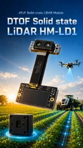
| DTOF Solid State LiDAR HM-LD1 Specifications | |
|---|---|
| Product Name | DTOF Solid State LiDAR HM-LD1 |
| Technology | SPAD dToF solid-state LiDAR |
| Dimension | 43.5 mm × 30 mm × 26.5 mm |
| Weight | 28 g |
| Indoor Ranging Capability | 0.5–25 m |
| Outdoor Ranging Capability | 0.2–8 m |
| Ranging Accuracy | ±3 cm |
| Field of View | 60° horizontal × 45° vertical |
| Resolution | 40 × 30 |
| Frame Rate | 10 fps |
| Interfaces | UART / UDP / UVC |
| Operating Temperature | -20 ℃ to 60 ℃ |
| Power Consumption | 1.2 W |
| Development Support | SDKs for x86 Windows, x86 Linux, and ARM Linux |
| Typical Applications | Drone obstacle avoidance, altitude hold, terrain following, robotic navigation, SLAM support, distance detection, smart inspection, security monitoring |
View Product Details & Pricing ➔
Download the technical brochure: DTOF SSL HM-LD1 Product Brochure
Why HM-LD1 Fits UAV Obstacle Avoidance Projects
The HM-LD1 is designed for compact 3D sensing where weight and integration flexibility matter. Its 28 g weight helps preserve flight time compared with heavier perception hardware. Its compact dimensions of 43.5 mm × 30 mm × 26.5 mm simplify installation on UAVs, autonomous mobile robots, and embedded systems with limited sensor space.
The module provides a 60° horizontal by 45° vertical field of view, which can support practical near-field perception in a defined direction. Its ±3 cm ranging accuracy supports distance-aware decision-making. Indoor ranging capability of 0.5–25 m can be valuable for warehouse, nighttime, and controlled flight environments, while outdoor ranging capability of 0.2–8 m can support short-range obstacle detection and landing assistance in daytime conditions.
Depth Map and Point Cloud Output
HM-LD1 delivers real-time depth images and 3D point cloud data for environmental perception. These outputs can help developers measure distance to nearby objects, detect unsafe proximity, support terrain awareness, and build perception functions for robotics and UAV navigation. Depth images are useful for structured processing, while point clouds can support spatial understanding and development workflows.
Supported Development Platforms
MRP offers SDKs for x86 Windows, x86 Linux, and ARM Linux, enabling development and integration across diverse operating systems and processor architectures. With UVC, UDP, and UART interfaces, HM-LD1 can be integrated with PCs, Raspberry Pi, flight-controller companion computers, and embedded platforms for prototyping and system deployment.
The HM-LD1 can support multiple applications for drones, robots, cameras, and security systems. It enables UAV altitude hold and terrain following, assists robot navigation, obstacle avoidance, and SLAM, and can also support autofocus, user presence detection, object recognition, volume measurement, and zone intrusion monitoring.
MRP specializes in perception and positioning modules for robots and UAVs, with technical support for product integration and application development. The product is manufactured by the original factory with in-house production for stable supply, and customized products may be developed on demand for specific project requirements.
Need help selecting a depth sensor for your UAV platform? Request pricing or prepare your order.
Application Scenarios for Obstacle-Avoidance Drones
Obstacle avoidance is useful across consumer, educational, and industrial UAV applications. The best implementation depends on mission speed, operating environment, required sensing direction, and autonomy level. A beginner drone, a bridge inspection drone, and an indoor warehouse drone may all need obstacle sensing, but they do not need the same design.
Beginner and Training Drones
For beginner pilots, obstacle avoidance improves confidence and reduces crash risk during training. Automatic braking, landing protection, and hover stability can make early flight practice safer. Still, beginners should fly conservatively because no system can detect every obstacle in every condition. Thin branches, wires, glass, and side impacts remain common trouble spots.
DIY and Student UAV Projects
DIY and student projects often focus on low-cost perception stacks. A flight controller, companion computer, lightweight depth sensor, and simple avoidance software can demonstrate practical robotics concepts. UART, UDP, and UVC interfaces are useful because they provide multiple ways to access sensor data from Raspberry Pi, Jetson, embedded Linux boards, or PCs.
For a student team, the best path is to build one reliable behavior first. Detect an obstacle. Slow down. Stop or hover. Log the data. Repeat the test. Once the system behaves consistently, then add more advanced logic. That approach saves time, saves airframes, and prevents a lot of late-night debugging.
Industrial Inspection Drones
Industrial inspection drones often fly near bridges, dams, expressways, warehouses, pipelines, towers, and industrial structures. These environments may include GPS-challenged areas, close surfaces, beams, cables, pipes, and uneven terrain. A drone depth sensor can support safer proximity awareness, especially when flying slowly near valuable infrastructure.
In inspection work, the goal is not always high-speed avoidance. Often, the goal is controlled close-range positioning. The UAV needs to hold a predictable distance from a surface, avoid bumping into beams or walls, and maintain enough clearance for the payload to collect useful data. That is where compact depth sensing can be especially practical.
Follow-Me, Off-Road Trail, and Vehicle Tracking Drones
Follow-me drones and vehicle tracking UAVs must track a moving subject while avoiding trees, slopes, people, rocks, signs, and vehicles. GPS and visual tracking may locate the target, but obstacle sensing helps determine whether the path is safe. Range, field of view, frame rate, and software response are especially important when the drone follows a moving object.
Look, follow-me flight looks simple in marketing videos because the best clips are filmed in open spaces. Real trails are messy. Branches reach into the flight path. Terrain rises quickly. People appear from behind curves. Vehicles kick up dust. A good obstacle sensing strategy helps the drone make better decisions when the tracking target is not the only thing that matters.
Autonomous Landing and Terrain Following
Landing is one of the most accident-prone phases of UAV operation. Downward or angled LiDAR can support ground distance measurement, terrain height estimation, and altitude stabilization over uneven surfaces. For terrain following, the drone continuously measures the surface below or ahead and adjusts height to maintain safer clearance.
Autonomous landing also requires practical safety logic. The system should know when the landing zone looks unsafe, when descent should slow, and when the drone should abort or hold. Depth data can help, but it should be combined with conservative control behavior and realistic testing.
Warehouse and Indoor Navigation
Indoor drones operate without reliable GPS and must avoid walls, racks, pallets, ceilings, equipment, and people. Depth sensing can support short-range obstacle detection, while SLAM, optical flow, IMU data, and other localization methods support navigation. Indoor environments are often ideal for compact dToF LiDAR because lighting can be controlled and the required operating range is frequently within practical sensor limits.
Warehouses also create repeated geometry: long aisles, shelves, boxes, pallets, and vertical rack structures. These conditions can be difficult for some vision systems, especially when lighting is uneven or surfaces repeat. A direct depth sensor gives the software another way to measure clearance and avoid near-field obstacles.
Limitations and Engineering Trade-Offs
Trustworthy obstacle avoidance design requires honest discussion of limitations. No drone obstacle avoidance sensor guarantees perfect collision prevention. Every technology has range limits, environmental sensitivities, blind spots, and algorithmic dependencies. Anyone promising flawless avoidance in every condition is selling more confidence than engineering.
No Sensor Guarantees Perfect Collision Avoidance
Thin wires, transparent surfaces, fast-moving objects, small branches, dark materials, and extreme weather can remain challenging. A sensor may detect an object late, inconsistently, or not at all depending on geometry and reflectivity. Collision avoidance also depends on flight controller tuning, braking performance, software logic, payload mass, and wind conditions.
Outdoor Sunlight and Surface Reflectivity
Strong sunlight can reduce the performance of some optical sensors. Dark or low-reflectivity objects may reduce range, while reflective surfaces may create unstable or misleading readings. Outdoor testing should include the expected time of day, surface types, and environmental conditions. Do not assume a sensor that works in the lab will behave the same way at noon on concrete, metal, water, or glass.
Flight Speed vs Detection Range
Faster drones need longer detection distance because they travel farther before the system can detect, process, decide, and brake. Short-range sensors are best for slower autonomous operations, landing, hovering, docking, indoor flight, and near-field protection. Engineers should calculate braking distance and add a safety margin.
FOV Coverage and Blind Spots
A single sensor cannot see all directions unless it is designed for panoramic coverage. A forward sensor does not detect obstacles behind or to the side. A downward sensor does not protect against a wall ahead. Full multi-directional UAV obstacle avoidance may require multiple sensors, careful placement, and software fusion.
Software Validation and Safety Testing
Testing should begin in controlled environments. Developers should simulate or stage obstacle scenarios, use safety nets or tethered tests when appropriate, and validate failsafe behavior. The system should define how the drone behaves when depth data becomes noisy, delayed, saturated, or unavailable.
In the shop and in the field, the boring tests are the ones that save aircraft. Verify the sensor stream. Verify timestamps. Verify latency. Verify what happens when the cable disconnects. Verify what happens when the obstacle is off-center. Verify what happens when the drone is already moving too fast. That is how obstacle avoidance becomes an engineering feature instead of a demo.
Buyer and Developer Checklist for Drones with Obstacle Avoidance
- ✅ Define whether the drone needs warning, braking, rerouting, landing assistance, or full autonomous navigation.
- ✅ Determine required sensing direction: forward, downward, upward, lateral, or 360-degree coverage.
- ✅ Calculate safe detection range based on maximum flight speed and stopping distance.
- ✅ Check indoor and outdoor ranging performance separately.
- ✅ Evaluate field of view against the drone’s flight envelope.
- ✅ Confirm weight and power consumption fit the UAV payload budget.
- ⚙️ Choose interfaces compatible with your controller or companion computer.
- ⚙️ Confirm SDK support for your operating system and processor architecture.
- ⚙️ Test performance under expected lighting, temperature, vibration, and surface conditions.
- ⚙️ Plan failsafe behavior if sensor data becomes unavailable or unreliable.
For consumer buyers, the best drone with obstacle avoidance is the one that offers reliable multi-directional sensing, stable GPS positioning, predictable return-to-home behavior, and strong hover control. For UAV developers and OEMs, the better question is which sensor architecture fits the mission. Compact dToF LiDAR modules can be especially useful where short-range depth perception, low weight, and embedded integration matter.
Final Thoughts: Choosing Smarter UAV Sensing for Safer Flight
Obstacle avoidance is a system, not a single feature. The right solution depends on mission speed, environment, required range, field of view, accuracy, weight, power, interface, and software capability. Consumer users should prioritize reliable multi-directional sensing, stable positioning, and return-to-home safety. Developers and OEMs should design around the full perception-control pipeline.
Compact dToF LiDAR modules such as the HM-LD1 can support short-range obstacle detection, depth mapping, landing assistance, terrain following, and robotic navigation. They are especially relevant where lightweight design, embedded integration, and real-time depth data are important. Explore the DTOF Solid State LiDAR HM-LD1 to evaluate compact 3D sensing for your next UAV or robotics project.
FAQ: Drones with Obstacle Avoidance
What drone has the best obstacle avoidance for beginners who are afraid of crashing?
Can I build a low-cost obstacle avoidance drone for a student or DIY project?
Do drones with obstacle avoidance work for follow-me, off-road trails, or vehicle tracking?
Is LiDAR better than camera-based obstacle avoidance for drones?
How much range does a drone obstacle avoidance sensor need?
Can one sensor provide full 360-degree obstacle avoidance?
What is the role of obstacle avoidance in autonomous landing?
Do obstacle avoidance drones work indoors without GPS?
What interfaces are important for integrating obstacle avoidance sensors?
What are the biggest limitations of drone obstacle avoidance?
📚 References & Further Reading
- Industry Standard: Cepton Technologies and Blickfeld for broader LiDAR industry context
- Related Guide: What Is RTK? The Centimeter-Level GPS Navigation Guide
- Related Guide: dToF: The Invisible Eye Seeing the 3D World
- Product Resource: DTOF Solid State LiDAR HM-LD1






