Cheap Drone LiDAR: How to Choose a Budget-Friendly Sensor for UAV Mapping, Obstacle Avoidance, and R&D
Searching for cheap drone lidar usually means one of two things. Either you need an affordable sensor for UAV obstacle avoidance and autonomous navigation, or you are trying to bring down the cost of aerial mapping and 3D scanning. Here’s the deal: both goals are possible, but they are not the same job. A lightweight dToF LiDAR module can be a strong fit for short-range perception, altitude hold, terrain following, and R&D. A professional UAV mapping payload, on the other hand, costs much more because it usually includes calibrated optics, high-end GNSS/INS, multi-return capability, tight time synchronization, and serious post-processing tools.
This guide walks through how to choose a budget-friendly drone LiDAR sensor without underbuying, overpaying, or chasing the wrong spec sheet. You will see the difference between mapping LiDAR and perception LiDAR, which specifications actually matter on a small UAV, and how outdoor range, field of view, frame rate, weight, power, interface, and SDK support affect real integration work. We will also look at when a compact solid-state dToF module such as the DTOF Solid State LiDAR HM-LD1 makes more sense than a full survey payload. If your project involves UAV obstacle avoidance, smart inspection, terrain following, robotic vision, or early-stage R&D, this guide will help you evaluate a low-cost LiDAR option with realistic expectations.
If you are developing a lightweight UAV perception system, use this guide to compare range, FOV, weight, power, and software integration before selecting a sensor. For more examples of robotics and UAV perception use cases, see our applications page.
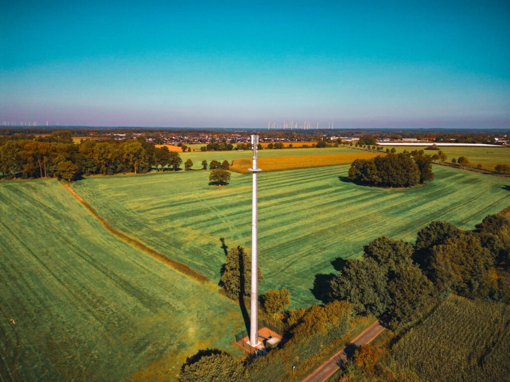
Sharing a compact dToF sensor we’ve been working with for drone obstacle av…
Table of Contents
- 👉 What Does “Cheap Drone LiDAR” Really Mean?
- 👉 Types of Drone LiDAR: Mapping, Obstacle Avoidance, and R&D Sensors
- 👉 How Drone LiDAR Works: ToF, dToF, Point Clouds, and Depth Maps
- 👉 Budget LiDAR vs Survey-Grade UAV LiDAR
- 👉 Key Specifications to Check Before Buying Cheap Drone LiDAR
- 👉 Drone Integration: Weight, Power, Interfaces, and SDKs
- 👉 Best Applications for Low-Cost Drone LiDAR
- 👉 Budget-Friendly Product Example: DTOF Solid State LiDAR HM-LD1
- 👉 Cheap Drone LiDAR Selection Checklist
- 👉 Common Mistakes When Buying Budget UAV LiDAR
- 👉 FAQ: Cheap Drone LiDAR
What Does “Cheap Drone LiDAR” Really Mean?
“Cheap” is a relative word in UAV LiDAR. For a university lab, robotics startup, or drone integrator building obstacle avoidance, cheap may mean a compact sensor module that can be purchased and integrated without rebuilding the aircraft from scratch. For a geospatial survey company, cheap may still mean a payload costing thousands or tens of thousands of dollars if it can deliver reliable, georeferenced mapping data. Look, the important question is not just the sensor price. The real question is whether the LiDAR gives your drone the type of data it needs at the speed, range, accuracy, weight, and power level your platform can support.
Cheap for Navigation Is Not the Same as Cheap for Mapping
Navigation LiDAR and mapping LiDAR are built around different success criteria. A navigation sensor helps the drone make immediate decisions: slow down, maintain height, avoid a wall, follow terrain, or detect a nearby structure. A mapping LiDAR payload focuses on producing a spatial dataset that can be processed, measured, and delivered as a professional point cloud. Mapping requires not only LiDAR measurements but also accurate drone pose, timing, calibration, and post-processing. That is why a budget drone LiDAR module can be highly effective for perception but should not be confused with a complete aerial survey system.
The Real Question: What Does the Drone Need to Decide?
In the shop, the best engineering decisions start with the mission, not the brochure. Does the aircraft need to know whether there is an obstacle ahead? Does it need to estimate ground distance for low-altitude flight? Does it need to fly near bridges, expressways, dams, tanks, racks, or other structures without collision? Does the onboard computer need a local point cloud for autonomy development? If the answer is yes, a compact dToF LiDAR module may deliver excellent value. If the aircraft must produce certified topographic data over large areas, you should evaluate a survey-grade payload instead.
When a Budget LiDAR Module Makes Sense
A budget LiDAR module makes sense when the drone needs real-time depth information, short-range 3D perception, and clean integration with a companion computer or embedded controller. Typical use cases include UAV obstacle avoidance, altitude hold, terrain following, short-range inspection, robotics R&D, SLAM experimentation, embedded perception development, and smart monitoring. In these applications, a lightweight and low-power sensor can be more valuable than a larger, more expensive payload because every gram and watt affects endurance, stability, and integration time.
Types of Drone LiDAR: Mapping, Obstacle Avoidance, and R&D Sensors
Before comparing datasheets, classify the sensor type. Many buying mistakes happen because teams compare a compact perception module against a professional mapping payload as if they were interchangeable. They are not. Both use light-based distance measurement, but they are optimized for different data outputs, different installation requirements, and different workflows after the flight.
Survey-Grade UAV LiDAR Payloads
Survey-grade UAV LiDAR payloads are designed for aerial mapping, topography, forestry, corridor mapping, powerline inspection, and infrastructure documentation. They typically combine a LiDAR scanner with GNSS/INS, synchronization electronics, calibrated mounting, and post-processing workflows. The final deliverable is usually a georeferenced dense point cloud. These systems can be powerful, but they are expensive and complex. The LiDAR sensor is only one part of the total system; positioning, calibration, flight planning, and data processing are equally important.
Solid-State LiDAR Modules for UAV Perception
Solid-state LiDAR modules are attractive for drones because they avoid large rotating assemblies, reduce mechanical complexity, and are often compact enough to fit into small UAV payload envelopes. They can output depth maps, distance data, or short-range point cloud information. This makes them suitable for drones, mobile robots, smart cameras, embedded vision systems, and development platforms. Industrial automation suppliers such as HOKUYO are widely known in the LiDAR and sensing market, especially for robotics and automation applications, which shows how mature laser-based sensing has become across industrial use cases.
Single-Point Rangefinders vs 3D Depth LiDAR
A single-point rangefinder measures distance in one direction. It can be useful for altitude hold, landing assistance, or simple proximity sensing, but it cannot describe the shape or position of obstacles across a wider area. A 3D depth LiDAR provides spatial information across a field of view. For obstacle avoidance, depth imaging is usually more useful because the drone can detect whether the obstacle is centered, above, below, or off to one side. For R&D teams working on autonomy, a depth map or point cloud is also easier to use in perception algorithms than a single number.
Mechanical Scanning LiDAR vs Solid-State LiDAR
Mechanical scanning LiDAR systems may offer wider scan patterns or dense coverage depending on the design, but they can also increase size, power, and mechanical sensitivity. Solid-state modules are often smaller, lower power, and more robust for embedded development. On small UAVs, weight and power can matter as much as range. A sensor that looks impressive on a bench may reduce flight time, shift the center of gravity, require a larger aircraft, and increase the total system cost.
How Drone LiDAR Works: ToF, dToF, Point Clouds, and Depth Maps
LiDAR stands for light detection and ranging. In practical terms, the sensor emits light and measures the returned signal after it reflects from a surface. From this measurement, the system estimates distance. For drone engineers, the value is not the physics by itself. The value is turning distance data into flight decisions, local maps, inspection support, or perception features the aircraft can actually use.
Time-of-Flight Distance Measurement
Time-of-flight measurement is based on the time delay between emitted light and returned light. Because light travels extremely fast, measurement timing must be precise. Surface reflectivity, sunlight, angle of incidence, material type, and distance all influence return strength. A bright target may be easier to detect than a dark target, and a flat surface facing the sensor may return more signal than an angled or absorbent surface. This is why drone LiDAR should always be tested in the actual operating environment, not only in ideal indoor conditions.
What dToF Means
dToF means direct Time-of-Flight. Instead of inferring distance indirectly, a dToF sensor measures the actual travel time of emitted photons. SPAD-based dToF technology can support compact depth sensing because single-photon avalanche diode arrays are sensitive enough to detect very small amounts of returned light. For UAV perception, this can enable small modules that deliver depth images and 3D point cloud data without the size and power burden of larger scanning systems.
Depth Map vs Point Cloud
A depth map is a two-dimensional grid where each pixel stores distance. It is similar to an image, but the pixel value represents depth rather than color. A point cloud projects those depth measurements into 3D space using the sensor geometry and calibration. For drones, depth maps are efficient for real-time obstacle detection because they can be processed like images. Point clouds are useful for local reconstruction, SLAM development, object shape understanding, and environmental perception. However, a local point cloud from a compact sensor is not the same as a georeferenced survey point cloud from a professional mapping payload.
Why Resolution and Frame Rate Matter
Resolution controls how much spatial detail the depth sensor can capture. A higher resolution sensor can identify smaller features or better define object boundaries, but it may require more bandwidth and processing. Frame rate affects how quickly the drone receives updated information. A 10 fps sensor can be suitable for low-speed obstacle detection, proximity sensing, controlled UAV experiments, and development work. For faster aircraft, engineers must calculate stopping distance, control loop latency, braking capability, and safety margin instead of assuming the sensor alone solves the problem.
How Outdoor Sunlight Affects Budget LiDAR
Outdoor sunlight is one of the most important practical factors for cheap drone LiDAR. Ambient light adds noise and can reduce effective range. A sensor that reaches long distances indoors may have a shorter range in bright daylight. Always compare indoor and outdoor specifications separately. For UAV applications, the outdoor range is often more important than the maximum indoor number because many drones operate in sunlight, near reflective structures, or around surfaces with different materials.
Budget LiDAR vs Survey-Grade UAV LiDAR
The phrase “cheap drone LiDAR” often creates confusion because people use it for both perception modules and mapping systems. The table below clarifies the main difference from an engineering and procurement perspective.
| Category | Budget Drone LiDAR Module | Survey-Grade UAV LiDAR Payload |
|---|---|---|
| Primary Purpose | Obstacle avoidance, altitude hold, terrain following, R&D, short-range perception | Professional mapping, topography, forestry, corridor survey, infrastructure inspection |
| Typical Data Output | Depth map, short-range point cloud, distance data | Georeferenced dense point cloud |
| Positioning Requirement | May work with onboard perception only | Usually requires high-grade GNSS/INS |
| Integration Complexity | Moderate; often suitable for embedded platforms | High; requires calibration, synchronization, and post-processing |
| Best For | Developers, R&D teams, small UAV autonomy, robotics prototypes | Survey companies, forestry mapping, civil engineering, geospatial professionals |
Accuracy: Local Distance Accuracy vs Global Mapping Accuracy
Sensor ranging accuracy is not the same as global mapping accuracy. A LiDAR module may measure distance to a nearby object with centimeter-level accuracy, but a georeferenced map also depends on the aircraft position, attitude, time synchronization, calibration, and processing workflow. Local distance accuracy helps with obstacle avoidance and terrain following. Global accuracy is required when the final output must align with survey control points, engineering drawings, or geospatial datasets.
Why GNSS/INS Can Cost More Than the LiDAR Sensor
For mapping applications, the positioning subsystem can be a major cost driver. A drone must know where it is and how it is oriented at the exact time each LiDAR measurement is captured. That often requires GNSS, inertial measurement, time synchronization, and post-processing. For UAV positioning and navigation system context, suppliers such as Unicore Communications provide GNSS technologies used across navigation and industrial applications. If your project does not require georeferenced mapping, you may not need that level of positioning infrastructure.
When Budget LiDAR Is the Smarter Choice
Budget LiDAR is often the smarter choice when the drone only needs obstacle distance, terrain proximity, safe standoff from structures, local 3D perception, or data for R&D. Overbuying a survey payload can add cost, mass, power draw, and software complexity. For development teams, reducing integration burden can be more valuable than buying the highest-spec sensor available.
Key Specifications to Check Before Buying Cheap Drone LiDAR
This is where procurement needs to become engineering-driven. A low-cost sensor that lacks the right range, interface, or software support can become expensive after weeks of driver development and rework. The following specifications should be reviewed before buying any cheap drone LiDAR module.
Range: Indoor Range vs Outdoor Range
Indoor maximum range often looks better than outdoor range because indoor lighting is easier to control. For UAVs, outdoor range must be checked separately. The DTOF Solid State LiDAR HM-LD1 specifies indoor ranging of 0.5–25 m and outdoor ranging of 0.2–8 m. That makes it suitable for short-range perception, obstacle avoidance, altitude measurement, and development, not long-range aerial survey scanning.
Ranging Accuracy
Ranging accuracy affects altitude hold, obstacle distance estimation, and point cloud reliability. The HM-LD1 specifies ±3 cm ranging accuracy. For many UAV perception tasks, this is useful because the drone needs to maintain safe clearance, detect nearby surfaces, or estimate local geometry. However, this should not be interpreted as survey-grade absolute map accuracy. Mapping accuracy requires additional positioning and calibration systems.
Field of View
Field of view determines how much of the environment the sensor can see. A wider FOV helps cover more area, while a narrower FOV may miss obstacles outside the sensing cone. The HM-LD1 provides a 60° horizontal by 45° vertical FOV, which is useful for forward, downward, or angled perception depending on mounting design. The best FOV depends on drone speed, expected obstacle size, mounting location, and avoidance algorithm.
Resolution
Resolution controls the density of the depth image. The HM-LD1 resolution is 40 × 30, which provides compact 3D perception data suitable for embedded development and short-range sensing. It is not intended to replace a high-density mapping scanner. For obstacle avoidance and proximity sensing, the key question is whether the resolution is enough to identify the obstacles that matter in the planned flight envelope.
Frame Rate
Frame rate affects reaction time. The HM-LD1 operates at 10 fps. This can be suitable for low-speed UAV obstacle detection, altitude sensing, inspection, robotics R&D, and controlled experiments. Faster drones need more range, faster perception, or conservative speed limits. Always evaluate frame rate together with drone velocity, braking distance, processing latency, and control-loop response.
Weight
Small UAVs are highly sensitive to payload mass. Every gram affects flight time, stability, and remaining capacity for batteries, compute modules, cameras, or protective housings. The HM-LD1 weighs 28 g, which is attractive for small drones where weight directly affects endurance and maneuverability.
Power Consumption
Power consumption affects battery life and thermal design. The HM-LD1 consumes 1.2 W, reducing the burden on the drone power system compared with heavier payloads. Low power also helps when the sensor is integrated into compact enclosures, where heat buildup can reduce system reliability.
Interface Compatibility
Interfaces determine how quickly your team can make the sensor useful. UART is useful for embedded controllers and simple data communication. UDP is useful for network-based data transmission to a companion computer. UVC can make integration easier in camera-style pipelines on PCs and embedded platforms. The HM-LD1 supports UART, UDP, and UVC, giving developers flexibility during prototyping and deployment.
SDK and Platform Support
Software support can be as important as sensor hardware. SDK availability reduces driver development time, integration risk, and debugging cost. MRP offers SDKs for x86 Windows, x86 Linux, and ARM Linux, enabling integration across PCs, Raspberry Pi-style platforms, embedded Linux boards, and development computers. Need a compact LiDAR for UAV obstacle avoidance or robotics R&D? Review the DTOF Solid State LiDAR HM-LD1 specifications.
Drone Integration: Weight, Power, Interfaces, and SDKs
Buying a cheap drone LiDAR sensor is only the beginning. The real engineering work is integration. A successful UAV LiDAR installation must consider aircraft balance, vibration, cable routing, power regulation, data bandwidth, software stack, mounting direction, and validation testing. This is where good projects separate themselves from rushed prototypes.
Payload Weight and Flight Time
Payload weight affects center of gravity, flight time, and control response. Even a small sensor should be mounted carefully so it does not shift the center of gravity beyond acceptable limits. Mounting brackets, cables, protective covers, and vibration isolation also add mass. Engineers should evaluate the full installation weight, not only the sensor module. A 28 g LiDAR module gives the mechanical team more flexibility than heavier payloads.
Power Budget and Thermal Design
Battery-powered systems require disciplined power budgeting. The sensor must receive stable power through an appropriate regulator, and the integration should avoid electrical noise from motors or ESCs where possible. Thermal design matters too. Even low-power devices can heat up inside sealed enclosures under sunlight. A 1.2 W sensor is easier to manage than a high-power payload, but airflow, enclosure design, and operating temperature should still be checked.
Interface Selection for Flight Controllers and Companion Computers
Interface choice depends on system architecture. UART can be appropriate for microcontrollers or flight-controller-level communication. UDP can support structured data transmission to a companion computer over a network. UVC can be convenient when the sensor is treated like a camera-style depth source. For a Raspberry Pi, Jetson, or Linux board, UVC and UDP workflows may speed development. For direct embedded control, UART may be preferred.
Software Stack: ROS, OpenCV, and Embedded Perception
A LiDAR module becomes more valuable when connected to a usable software stack. Development teams may feed depth data into ROS nodes, OpenCV pipelines, SLAM experiments, obstacle detection algorithms, or autonomy stacks. The integration should include timestamp handling, coordinate frames, filtering, calibration, and failsafe logic. For applications that require visual perception in addition to depth sensing, you can also compare LiDAR with a stereo vision option such as the 3D Stereo Vision Camera VIOBOT2.
Mounting Direction: Forward, Downward, or Angled
Mounting direction should match the mission. A forward-facing LiDAR supports obstacle avoidance against walls, trees, poles, racks, or structures. A downward-facing LiDAR supports altitude hold, landing assistance, and terrain following. An angled sensor can help with structure inspection, corridor navigation, or approach monitoring. In every configuration, verify that the propellers, landing gear, cables, or payload frame do not obstruct the field of view.
Best Applications for Low-Cost Drone LiDAR
Low-cost drone LiDAR is most valuable when used in applications that benefit from real-time distance and local 3D information. It is not always the right choice for professional survey deliverables, but it can be excellent for perception and autonomy development.
UAV Obstacle Avoidance
Obstacle avoidance is one of the strongest use cases for compact LiDAR. A drone can use depth data to detect walls, trees, poles, industrial equipment, shelves, beams, or other nearby objects. FOV and frame rate are critical. A sensor must see enough of the flight path and update quickly enough for the drone to react. For controlled-speed drones operating in inspection or research environments, compact dToF LiDAR can be a practical solution.
Altitude Hold and Terrain Following
Downward-facing LiDAR can measure ground distance more directly than barometric pressure or GPS altitude in many low-altitude scenarios. This is useful for landing assistance, terrain following, and maintaining a fixed standoff distance from a surface. In indoor or GNSS-denied environments, local distance sensing can provide valuable feedback for flight control or autonomy experiments.
Smart Inspection of Bridges, Expressways, and Dams
Inspection drones often operate near structures that are difficult or dangerous for people to approach. HM-LD1 product information highlights usefulness for measuring distances to objects such as bridges, expressways, and dams. Its outdoor ranging capability up to 8 m in daylight conditions makes it relevant for short-range standoff measurement, proximity awareness, and controlled inspection support. As always, teams should validate performance against the actual material, lighting, and surface angles found on site.
Robotics and UAV R&D
For universities, startups, and industrial R&D groups, a low-cost LiDAR sensor lowers the barrier to experimentation. Teams can prototype autonomous navigation, test depth perception algorithms, record local 3D data, and evaluate embedded compute pipelines without purchasing a full survey payload. This accelerates learning and helps teams define requirements before investing in larger systems.
SLAM and Local 3D Perception
Budget LiDAR can support local perception and experimental SLAM, especially when paired with IMU data, visual data, or wheel odometry in robotic systems. For UAVs, vibration, motion blur in companion sensors, limited FOV, and limited resolution must be considered. Compact modules are valuable for development, but dense, large-scale, georeferenced mapping usually requires more advanced sensors and positioning systems.
Security, Zone Monitoring, and Presence Detection
Low-cost dToF LiDAR can also support user presence detection, object recognition support, volume measurement, and zone intrusion monitoring. In fixed or mobile security systems, depth data helps distinguish spatial changes in a scene. On drones, similar concepts can support proximity alerts, restricted-zone monitoring, and automated inspection routines.
Budget-Friendly Product Example: DTOF Solid State LiDAR HM-LD1
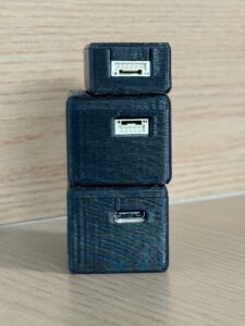
The DTOF Solid State LiDAR HM-LD1 is a compact SPAD dToF LiDAR module designed for real-time depth images and 3D point cloud data. For developers searching for cheap drone LiDAR for UAV perception, obstacle avoidance, altitude hold, terrain following, smart inspection, or robotics R&D, it provides a lightweight and low-power alternative to large survey-grade LiDAR payloads.
View DTOF Solid State LiDAR HM-LD1
| Specification | DTOF Solid State LiDAR HM-LD1 |
|---|---|
| Technology | Solid-state LiDAR based on SPAD dToF technology |
| Dimensions | 43.5 mm × 30 mm × 26.5 mm |
| Ranging Capability | Indoor: 0.5–25 m; Outdoor: 0.2–8 m |
| Ranging Accuracy | ±3 cm |
| Field of View | 60° horizontal × 45° vertical |
| Weight | 28 g |
| Resolution | 40 × 30 |
| Frame Rate | 10 fps |
| Interface | UART / UDP / UVC |
| Operating Temperature | -20 ℃ to 60 ℃ |
| Power Consumption | 1.2 W |
| SDK Support | x86 Windows, x86 Linux, ARM Linux |
| Typical Applications | UAV altitude hold, terrain following, obstacle avoidance, robot navigation, SLAM R&D, autofocus, presence detection, object recognition, volume measurement, zone intrusion monitoring |
View Product Details & Pricing ➔
Why HM-LD1 Fits Budget UAV Development
The HM-LD1 is designed around the constraints that matter on small drones and embedded platforms. Its 28 g weight helps preserve flight time and payload capacity. Its 1.2 W power consumption reduces load on the UAV battery and simplifies thermal design. Its compact dimensions of 43.5 mm × 30 mm × 26.5 mm support integration into robots, UAVs, cameras, and security systems where space is limited. The module delivers real-time depth images and 3D point cloud data for accurate environmental perception in suitable short-range scenarios.
Outdoor and Indoor Ranging Expectations
HM-LD1 supports indoor or nighttime ranging up to 25 m and outdoor daytime ranging up to 8 m. Product information notes accurate measurement from long distances of 8 m on a clear summer day under strong ambient light conditions. Outdoor results depend on sunlight, target reflectivity, surface angle, weather, and installation. Engineers should test the sensor against the actual materials and lighting conditions expected in the UAV mission.
Interfaces for Prototyping and Deployment
HM-LD1 supports UVC, UDP, and UART interfaces. UVC is useful for PC-style vision pipelines and camera-like data workflows. UDP supports network streaming to a companion computer. UART supports embedded communication where simpler control or distance data is required. SDK support for x86 Windows, x86 Linux, and ARM Linux helps development teams integrate the module across PCs, Raspberry Pi, Linux boards, and embedded platforms.
Recommended Use Cases
Recommended use cases include drone obstacle avoidance, downward altitude measurement, terrain following, smart inspection, robotics R&D, short-range 3D perception, embedded vision development, user presence detection, object recognition support, volume measurement, and zone intrusion monitoring. The module is especially relevant when the system needs local depth data but cannot support the weight, cost, or power draw of a larger LiDAR payload.
Download Product Brochure
Download DTOF SSL HM-LD1 Product Brochure
Cheap Drone LiDAR Selection Checklist
Use this checklist before purchasing a low-cost LiDAR sensor for a UAV platform. It will help prevent common specification mismatches, hidden integration costs, and avoidable delays once the drone is on the bench.
- ✅ Define the mission: obstacle avoidance, mapping, inspection, terrain following, landing assistance, or R&D.
- ⚙️ Check outdoor range: do not rely only on indoor maximum range.
- ✅ Confirm field of view: make sure the sensing area matches the flight scenario.
- ⚙️ Review frame rate: faster drones require faster perception and control response.
- ✅ Evaluate weight: small UAVs require lightweight sensors to preserve flight time.
- ⚙️ Calculate power budget: confirm the sensor can run from the UAV’s available power system.
- ✅ Check interfaces: UART, UDP, and UVC support different integration workflows.
- ⚙️ Confirm SDK support: Windows, Linux, and ARM Linux support can reduce development cost.
- ✅ Understand mapping limitations: budget LiDAR modules are not always survey-grade mapping payloads.
- ⚙️ Ask about integration support: technical support can be as important as sensor price.
If you are evaluating a lightweight LiDAR for UAV perception or robotics R&D, review the HM-LD1 specifications or contact our team for integration guidance.
Common Mistakes When Buying Budget UAV LiDAR
Mistake 1: Comparing Only Maximum Range
Maximum range may be measured under favorable conditions. Outdoor sunlight, dark targets, angled surfaces, and low reflectivity can reduce performance. Always review both indoor and outdoor range. For drones, the outdoor number is often more relevant than the laboratory maximum.
Mistake 2: Ignoring Weight and Power
A sensor may be inexpensive as a component but expensive as a system if it reduces flight time or requires a larger drone. Extra batteries, larger airframes, stronger mounts, and more powerful regulators can increase total cost. Lightweight, low-power modules can reduce this integration burden.
Mistake 3: Expecting Survey-Grade Mapping from a Perception Module
Perception modules can create depth maps and local point clouds, but survey-grade mapping requires georeferencing, calibration, scan density, GNSS/INS, and workflow tools. If your deliverable is a professional terrain model, evaluate a complete mapping payload. If your need is obstacle avoidance or local sensing, a compact module may be the correct choice.
Mistake 4: Forgetting Software Integration
Hardware cost is only part of the project. Drivers, SDKs, documentation, sample code, and support determine how quickly your team can use the sensor. A slightly more capable module with better integration support may cost less in total engineering time than a cheaper sensor with limited documentation.
Mistake 5: Choosing the Wrong Field of View
FOV must match the mounting position and flight scenario. Too narrow, and obstacles may be missed. Too wide, and angular detail may be reduced for a given resolution. Forward-facing obstacle avoidance, downward terrain following, and angled inspection all have different FOV requirements. Validate coverage on the actual drone geometry.
HM-LD1 dToF Solid-State LiDAR: Compact Depth Sensing for UAVs & Robotics
FAQ: Cheap Drone LiDAR
Can I get a useful drone LiDAR system under $1k or $10k?
Is cheap drone LiDAR suitable for scanning under vegetation or wooded areas?
What should beginners check before buying a LiDAR for a small drone?
Can cheap drone LiDAR be used for obstacle avoidance?
Is LiDAR better than stereo vision for budget drones?
What is the difference between a depth map and a point cloud?
How much outdoor range do I need for drone LiDAR?
Can I use cheap drone LiDAR for SLAM?
What interfaces should a cheap drone LiDAR support?
Is a lightweight LiDAR module enough for industrial inspection drones?
Choosing cheap drone LiDAR is not about buying the lowest-cost sensor; it is about matching sensor performance to the UAV mission. For obstacle avoidance, altitude hold, terrain following, smart inspection, and R&D, a compact dToF module such as HM-LD1 can provide a practical balance of size, power, range, and integration flexibility. Review the product page to confirm fit for your platform.
📚 References & Further Reading
- Industry Standard: HOKUYO and Unicore Communications
- Related Guide: Robotics and UAV Applications, DTOF Solid State LiDAR HM-LD1, and 3D Stereo Vision Camera VIOBOT2