

iPhone LiDAR Explained: Is It Good Enough for 3D Scanning, Measurement, and Robotics?
iPhone LiDAR has made depth sensing feel a lot less exotic. A few years ago, if you wanted to capture depth data, scan a room, or build a spatial model, you were usually talking about dedicated hardware, calibration time, and a workflow that belonged in a lab, jobsite, or robotics shop. Now, with a recent iPhone Pro or iPad Pro, a person can walk into a room, point a phone around, and get a usable scan, an AR furniture preview, a rough floor plan, or a quick 3D reference model in a few minutes.
That is genuinely useful. For architects, designers, educators, hobbyists, field teams, and makers, having a depth sensor in a consumer device is a big step forward. The phone can estimate distance, recognize major surfaces, and give software enough spatial context to do things that used to require more specialized tools. But here’s the deal: once the question changes from “Can I scan this?” to “Can I measure this accurately, automate this robot, or build a repeatable 3D perception system?”, the limits of iphone lidar start to matter a lot more.
This guide explains what iPhone LiDAR actually does, where it works well, and where it falls short for 3D scanning, measurement, robotics, SLAM, UAV obstacle avoidance, and embedded machine vision. It also compares consumer mobile LiDAR with dedicated dToF solid-state LiDAR modules, including the DTOF Solid state LiDAR HM-LD1, which provides defined ranging capability, point cloud and depth map output, 60° × 45° field of view, 10fps frame rate, UART/UDP/UVC interfaces, and SDK support for Windows, Linux, and ARM Linux platforms.
Look, the iPhone is a very capable consumer device. It is also not the same thing as an industrial sensor you bolt into a robot, connect to an embedded board, and expect to run predictably every day. By the end of this guide, you should have a clear feel for when iPhone LiDAR is enough, when it is mostly a convenient demo tool, and when an engineering-grade depth sensor is the smarter choice.
Table of Contents
- 👉 What Is iPhone LiDAR?
- 👉 How iPhone LiDAR Works
- 👉 What People Actually Use iPhone LiDAR For
- 👉 Is iPhone LiDAR Good Enough for 3D Scanning?
- 👉 iPhone LiDAR Measurement Accuracy and Limitations
- 👉 Can iPhone LiDAR Be Used for Robotics?
- 👉 iPhone LiDAR vs Industrial dToF LiDAR
- 👉 Industrial Alternative: DTOF Solid State LiDAR HM-LD1
- 👉 When LiDAR Needs RTK Positioning
- 👉 How to Choose the Right Depth Sensor
- 👉 Conclusion
- 👉 FAQ
What Is iPhone LiDAR?
iPhone LiDAR is Apple’s mobile depth-sensing feature used in selected iPhone Pro and iPad Pro models. LiDAR means Light Detection and Ranging. In plain shop language, the system sends out light, watches how that light returns from nearby surfaces, and uses the timing information to estimate distance. If you want the basic technology background, see our guide on what LiDAR stands for and how light-based distance measurement works.
On an iPhone, LiDAR is mainly there to support augmented reality, camera assistance, room mapping, plane detection, scene understanding, and app-based 3D scanning. It helps the device understand the approximate shape of the space in front of it. That lets AR objects sit more convincingly on floors, walls, tables, and other surfaces. It can also help scanning apps generate room meshes and spatial models faster than camera-only methods in some workflows.
iPhone LiDAR in Simple Terms
The most practical way to think about iPhone LiDAR is this: it is a consumer spatial-awareness feature, not a standalone industrial sensor. It works together with the camera system, motion sensors, processor, operating system, and application software. The result you see depends heavily on the app, the surface material, the lighting, the distance, and how carefully the operator moves the phone through the scene.
In the shop, that distinction matters. A phone scan can be handy for capturing room context or showing a customer where equipment might sit. But if you are trying to build a machine that detects obstacles, logs depth frames, controls motion, or repeats the same measurement every shift, you need to look past the convenience and ask what data the sensor actually provides.
Consumer LiDAR vs Industrial LiDAR
iPhone LiDAR is not the same class of tool as professional survey LiDAR, automotive LiDAR, or an industrial robotics LiDAR module. A consumer phone is built around compactness, convenience, battery life, camera features, and a polished app experience. An engineering-grade sensor is judged by published range, accuracy, repeatability, resolution, frame rate, interface, power consumption, operating temperature, mounting options, integration workflow, and long-term data stability.
That does not make one “good” and the other “bad.” It means they are built for different jobs. iPhone LiDAR is excellent when a person wants a quick spatial reference. Industrial LiDAR is the better fit when a machine needs predictable data it can use for sensing, navigation, inspection, or control.
How iPhone LiDAR Works
iPhone LiDAR uses time-of-flight depth sensing. The basic principle is simple enough: light is emitted toward a scene, the light reflects from objects, and the system estimates distance from the return signal. In real use, though, the phone does not rely on LiDAR alone. It combines depth information with camera images, IMU data, device motion, Apple’s software stack, and app-level processing to build a useful understanding of the environment.
Time-of-Flight Depth Measurement
Time-of-flight sensing is valuable because it measures distance directly instead of estimating depth only from image features. That can make room-scale spatial capture faster and more stable in certain indoor spaces. Large walls, floors, doors, and furniture surfaces are usually easier targets than small parts or reflective objects.
The catch is that real-world surfaces are messy. Reflective metal, transparent glass, glossy plastic, very dark materials, direct sunlight, small edges, narrow holes, and complex geometry can all create difficult measurement conditions. The sensor may detect something, but the app still has to interpret it, filter it, and turn it into a measurement, mesh, floor plan, or AR scene.
Why Software Matters as Much as the Sensor
For most users, iPhone LiDAR is only experienced through apps. ARKit and scanning applications may use scene understanding, plane detection, mesh reconstruction, depth occlusion, and spatial anchors to create the final result. That means two apps can produce noticeably different outputs with the same phone in the same room.
One app may optimize for quick floor plans. Another may optimize for visual 3D models. Another may focus on AR placement. The hardware contributes depth information, but the software pipeline decides how that information is cleaned up, simplified, exported, and displayed. That is why a phone scan can feel impressive in one app and frustrating in another.
Why Raw Sensor Access Is Limited on iPhone
Industrial developers often want deterministic data streams, known frame rates, fixed interfaces, calibration details, and direct access to depth or point cloud data. With a phone, developers mostly work through Apple’s mobile software stack rather than an open industrial sensor interface. That is fine for mobile AR. It is less convenient for robotics teams that need to synchronize sensors, process data on an embedded computer, or feed depth information into navigation software.
In industrial and autonomous systems, companies such as Ouster build LiDAR sensors for machine perception, mapping, and autonomy, where specifications such as range, angular resolution, frame rate, and data interface are central engineering parameters. iPhone LiDAR is useful, but its workflow is fundamentally mobile-first.
What People Actually Use iPhone LiDAR For
People commonly use iPhone LiDAR for room scanning, floor plan generation, AR furniture placement, interior design, construction site reference capture, basic volume estimation, 3D model previews, education, and rough object scanning. Those are legitimate use cases. In fact, some of them are exactly where the phone shines because speed and convenience matter more than certified measurement accuracy.
Room Scanning and Floor Plans
Room scanning is one of the strongest use cases for iPhone LiDAR. A user can walk through a room, capture walls and surfaces, and generate a usable spatial reference. For renovation planning, real estate notes, furniture layout, or quick documentation, that can save a lot of time. You may not trust the result for precision construction, but it can be very useful for planning and communication.
Here’s the deal with room scans: big surfaces are forgiving. Floors, walls, ceilings, door openings, and large furniture pieces give the software enough geometry to build a reasonable model. If the job is “help me understand this space quickly,” iPhone LiDAR can do that well.
AR Placement and Scene Understanding
Another strong use case is augmented reality. LiDAR helps AR apps understand where floors, walls, tables, and large surfaces are located. This improves object placement, occlusion, and spatial stability. For example, a furniture app can place a virtual sofa in a room with better awareness of the floor plane, while an educational app can anchor virtual content in the physical environment.
That kind of work does not require the phone to behave like a calibrated inspection instrument. It needs enough spatial awareness to make the experience feel believable and stable. For consumer AR, that is often exactly the right level of performance.
Why Some Users Rarely Use It After Trying It
The novelty of iPhone LiDAR is high, but long-term workflow value depends on the user. Many people test scanning apps, create a few models, and then stop using them because export quality, mesh detail, or app workflow does not match what they actually need. A rough room model is useful. A noisy object mesh with soft edges and missing surfaces may not be.
For teams building deployable robots or UAV systems, dedicated robotics perception and positioning modules are usually easier to integrate than a consumer phone-based workflow. iPhone LiDAR is excellent for fast context capture, but weaker for repeatable industrial data pipelines.
Is iPhone LiDAR Good Enough for 3D Scanning?
iPhone LiDAR can be good enough for some 3D scanning tasks, but not all. The right answer depends on what “good enough” means. If the goal is room-scale scanning, layout planning, visual previews, or a rough spatial model, iPhone LiDAR can be very useful. If the goal is precision object capture, mechanical reverse engineering, detailed inspection, or high-quality 3D printing geometry, its limits show up fast.
Room-Scale Scanning
For rooms, hallways, furniture placement, and rough environmental capture, iPhone LiDAR performs well because large surfaces are easier to detect than small details. Walls, floors, doors, and large objects provide enough geometry for apps to build a useful map. This makes iPhone LiDAR attractive for real estate walkthroughs, interior design, facilities documentation, renovation planning, and quick project notes.
In a practical field workflow, that can be enough. If a contractor, designer, or technician wants to capture what a space looked like before changes were made, a phone scan can be a helpful reference. If the same person needs final dimensions for fabrication or compliance, they should still verify with proper measurement tools.
Object Scanning and 3D Printing
Object scanning is where expectations often get ahead of reality. Small parts, fine edges, sharp corners, glossy surfaces, black materials, transparent plastics, and complex mechanical geometry can produce poor results. Meshes may include noisy edges, missing surfaces, smoothed corners, inconsistent scale, and geometry that looks acceptable on a screen but fails when used for manufacturing.
For decorative objects or rough references, that may be acceptable. For parts that must fit into an assembly, match a tolerance, or be printed accurately, iPhone LiDAR is usually not the right tool by itself. In those cases, you either need a better scanning workflow, a higher-resolution sensor, a structured-light scanner, careful photogrammetry, or direct measurement using proper instruments.
Why Small Parts Are Difficult
Small objects demand higher spatial detail and better surface reconstruction. Photogrammetry may outperform iPhone LiDAR for textured objects because it can reconstruct fine visual details from many overlapping photos. LiDAR may help with scale and room geometry, while photogrammetry may help with surface appearance and texture.
For industrial use, though, the discussion should move away from app excitement and toward sensor specifications. You want to know range, accuracy, field of view, resolution, frame rate, output format, SDK support, power requirements, mounting constraints, and interface options. That is the information engineers need before they design around a sensor.
iPhone LiDAR Measurement Accuracy and Limitations
iPhone LiDAR can provide useful approximate measurements, especially at room scale. It can help users estimate distances, understand layouts, and create quick references. But it should not be treated as a universal precision measurement instrument. Apple’s mobile LiDAR implementation is designed for consumer AR and spatial awareness, not as a published industrial measurement module with open sensor-level specifications for every engineering parameter.
Why App-Based Measurements Vary
Measurement results vary because the final number depends on the sensor, the app, the surface, the distance, lighting conditions, user motion, scan angle, object geometry, and processing algorithm. A flat wall in good indoor conditions may produce a more stable reading than a shiny metal part, a glass panel, a dark curved object, or a small edge.
Operator technique matters too. Moving too quickly, scanning from a poor angle, standing too close, standing too far away, or failing to capture enough surrounding geometry can all degrade the result. In the shop, that is the difference between a handy reference and a measurement you would actually build from.
Accuracy vs Repeatability
For industrial users, accuracy is only one part of the problem. Repeatability is just as important. A measurement tool must produce consistent results across repeated tests, operators, installations, and environments. A consumer phone may be convenient, but a production robot, inspection device, UAV, or automation system usually needs defined performance.
Engineers want to know the operating range, field of view, frame rate, resolution, output format, temperature range, power consumption, latency, and interface before committing to a design. If those details are not available or are hidden behind app behavior, the system becomes harder to validate.
What Industrial Users Should Check Instead
Dedicated sensors are easier to evaluate because the specifications are explicit. For example, the DTOF Solid state LiDAR HM-LD1 specifies indoor ranging of 0.5–25m, outdoor ranging of 0.2–8m, ±3cm ranging accuracy, 60° × 45° FOV, 40 × 30 resolution, 10fps frame rate, UART/UDP/UVC interfaces, operating temperature from -20℃ to 60℃, and 1.2W power consumption.
Those numbers give engineers something concrete to design around. You can estimate coverage, power budget, mounting location, detection zone, data rate, host platform, and expected performance. That is a very different workflow from testing a mobile app and hoping the results stay consistent.
Can iPhone LiDAR Be Used for Robotics?
iPhone LiDAR can be used for robotics experiments, academic demonstrations, AR-based mapping prototypes, and human-in-the-loop visualization. It can help students and researchers explore depth sensing, spatial mapping, and mobile AR perception. But it is usually not the best option for deployable embedded robots, AMRs, AGVs, UAVs, or industrial automation systems.
Good for Demos, Limited for Deployment
A robot requires stable sensor mounting, continuous operation, deterministic data output, low-latency depth streams, synchronization with other sensors, predictable power behavior, and mechanical integration. A phone is a complete consumer computing device rather than a simple sensor module. It has a battery, screen, operating system, app lifecycle, thermal limits, camera stack, wireless behavior, and user-interface assumptions.
Those characteristics can be acceptable for demos. They are awkward for machines that need to run unattended. If a robot needs depth data every frame, tied into navigation and safety logic, you do not want the sensing architecture to depend on a handheld consumer device unless the whole system has been designed around that limitation.
Why Robots Need Open Interfaces
Robotics engineers often prefer sensors that provide standard interfaces such as UART, UDP, UVC, Ethernet, USB, or embedded SDK support. These interfaces allow the sensor to connect directly to a flight controller, Raspberry Pi, industrial PC, ARM Linux board, or embedded controller. The perception pipeline can then process data in ROS, OpenCV, SLAM software, navigation stacks, or custom control systems.
For teams debugging visual-inertial navigation or SLAM pipelines, our VIO, VINS, and VSLAM troubleshooting guide explains why sensor synchronization, calibration, lighting, and data consistency matter in real robotic systems. Look, a robot does not care whether a scan looks pretty in an app. It cares whether the sensor data arrives on time and means the same thing frame after frame.
SLAM, Obstacle Avoidance, and Embedded Vision
For SLAM, obstacle avoidance, UAV altitude hold, terrain following, zone monitoring, and embedded vision, the sensor must be selected as part of the machine architecture. Known FOV helps determine coverage. Known frame rate helps estimate latency. Known accuracy helps define safety margins. Known power consumption helps size the battery. Known operating temperature helps determine environmental suitability.
iPhone LiDAR can inspire prototypes, but dedicated modules such as HM-LD1 are better aligned with deployable perception systems. They are easier to mount, easier to power, easier to access from embedded systems, and easier to evaluate against engineering requirements.
iPhone LiDAR vs Industrial dToF LiDAR
The central difference between iPhone LiDAR and industrial dToF LiDAR is purpose. iPhone LiDAR is optimized for mobile AR, consumer scanning, camera assistance, and convenient spatial capture. Industrial dToF LiDAR is designed for machine perception, distance detection, robotic vision, obstacle avoidance, navigation, smart inspection, and embedded system integration.
Consumer Convenience vs Engineering Control
iPhone LiDAR wins on convenience. The user already has a phone, the interface is familiar, and apps can produce useful scans quickly. This is ideal for quick room capture, AR visualization, and non-critical measurement. No extra wiring, no SDK setup, no mechanical bracket, no embedded host computer.
Industrial LiDAR wins when engineers need control. A dedicated module provides published specifications, stable mounting, predictable data output, and defined hardware interfaces. This matters when the sensor must become part of a product, robot, drone, camera, inspection device, or automation system.
App Output vs Sensor Output
With iPhone LiDAR, output is often app-dependent. One application may export a mesh, another may generate a floor plan, and another may provide AR scene data. That is useful for people, but it is not always ideal for machines.
With HM-LD1, the product is positioned around real-time depth images and 3D point cloud data. That distinction is important. An industrial system usually needs sensor data that can be processed, logged, fused, synchronized, and used by control software. The sensor must serve the machine, not just the user interface.
When a Dedicated Module Is the Better Choice
A dedicated module is usually the better choice when the project involves autonomous navigation, obstacle detection, embedded measurement, UAV altitude hold, robot perception, security monitoring, volume measurement, or industrial automation. Automotive and robotics LiDAR companies such as Innoviz Technologies also show how the professional market evaluates LiDAR by range, reliability, integration architecture, safety, and perception performance rather than by app convenience alone.
For engineering teams, the question is not whether the sensor can create an impressive demo. The question is whether it can support a repeatable, maintainable, deployable system. That is where dedicated hardware starts to earn its keep.
Industrial Alternative: DTOF Solid State LiDAR HM-LD1
When iPhone LiDAR is not enough for robotics, embedded measurement, or outdoor ranging, a dedicated dToF solid-state LiDAR module gives engineers more control over the sensing pipeline. The DTOF Solid state LiDAR HM-LD1 is designed for real-time depth images and 3D point cloud output, making it suitable for obstacle avoidance, distance detection, autonomous navigation, smart inspection, robotic vision development, UAV altitude hold, terrain following, autofocus, user presence detection, object recognition, volume measurement, and zone intrusion monitoring.
Unlike a phone-based scanning workflow, HM-LD1 provides defined optical and electrical specifications, compact hardware, low power consumption, and integration interfaces including UART, UDP, and UVC. It supports SDKs for x86 Windows, x86 Linux, and ARM Linux, enabling development across PCs, Raspberry Pi-class systems, embedded Linux boards, and robotics platforms.
Product: DTOF Solid state LiDAR HM-LD1

| Specification | HM-LD1 Real Specification | Why It Matters for Industrial Use |
|---|---|---|
| Dimensions | 43.5mm × 30mm × 26.5mm | Compact size supports integration into AMRs, UAVs, embedded cameras, and space-limited robotic systems. |
| Ranging Capability | Indoor: 0.5–25m; Outdoor: 0.2–8m | Defined indoor and outdoor range makes system planning more predictable than app-based phone scanning. |
| Ranging Accuracy | ±3cm | Useful for obstacle detection, distance monitoring, robotic perception, and repeatable measurement workflows. |
| FOV | 60°(H) × 45°(V) | A known field of view helps engineers design sensor placement, coverage zones, and detection geometry. |
| Weight | 28g | Lightweight design is valuable for drones, mobile robots, handheld systems, and compact inspection devices. |
| Resolution | 40 × 30 | Provides depth map data for proximity sensing, obstacle awareness, and spatial perception tasks. |
| Frame Rate | 10fps | Supports real-time perception use cases where periodic depth updates are needed. |
| Interface | UART / UDP / UVC | Open interfaces simplify integration with PCs, Raspberry Pi, embedded controllers, and robotics systems. |
| Operating Temperature | -20℃ to 60℃ | Supports deployment across varied indoor and outdoor environments. |
| Power Consumption | 1.2W | Low power consumption is important for battery-powered robots, UAVs, and portable systems. |
Why HM-LD1 Is Better Suited for Embedded Robotics
HM-LD1 is built around defined sensing performance rather than app convenience. Its compact 43.5mm × 30mm × 26.5mm housing and 28g weight make it easier to install on mobile robots, UAVs, inspection devices, and embedded cameras. The 1.2W power consumption is important for battery-powered systems where every watt affects runtime, thermal design, and payload planning.
In the shop, those details are not marketing fluff. Weight affects brackets and payload. Power affects battery life and heat. Size affects mounting. Interface support affects how fast the engineering team can get useful data into the control system. That is why a small dedicated module can be a better fit than a powerful phone when the final product is a robot or embedded device.
Point Cloud and Depth Map Output
The module supports real-time depth images and 3D point cloud data for environmental perception. This is critical for systems that need to detect obstacles, monitor zones, estimate distance, support autonomous navigation, or feed perception algorithms. Rather than relying on a mobile scanning app, engineers can integrate the depth stream into their own system architecture.
That control matters during testing. Teams can log data, compare frames, tune filtering, synchronize with other sensors, and validate behavior under known conditions. That is the normal path for serious machine vision and robotics development.
Interfaces: UART, UDP, and UVC
HM-LD1 supports UART, UDP, and UVC interfaces, allowing integration with multiple types of host platforms. UART is useful for embedded controllers and simple data exchange. UDP supports network-style communication for systems that process data through onboard computers. UVC can simplify camera-like integration workflows.
This flexibility makes the module more practical than a phone for robots, UAVs, and industrial devices. A machine builder can choose the interface that matches the system architecture instead of forcing the architecture around a phone and mobile app.
Development Platform Support
MRP offers SDKs for x86 Windows, x86 Linux, and ARM Linux. This is valuable for prototyping and deployment because development teams may begin on a PC and later migrate to an embedded Linux board. For industrial users comparing iphone lidar with a dedicated module, this platform support is one of the clearest advantages of choosing a real sensor product.
A common development path is to test on a Windows or Linux workstation, validate the depth data, then move the same sensing concept onto a smaller embedded Linux host. That kind of path is much easier when the sensor was built for integration from the beginning.
View Product Details & Pricing ➔
When LiDAR Needs RTK Positioning
LiDAR measures surrounding geometry, but it does not automatically provide centimeter-level global position. This distinction is essential for outdoor robotics, UAV mapping, survey vehicles, construction automation, and infrastructure inspection. A LiDAR sensor can detect obstacles, ground, terrain, walls, vegetation, structures, and nearby objects. RTK GNSS helps the system understand where it is on the earth with high positional accuracy under suitable conditions.
A mobile robot or UAV may combine LiDAR for obstacle detection, cameras for visual perception, IMU data for motion estimation, VIO or VSLAM for localization, and RTK GNSS for centimeter-level outdoor positioning. The correct sensor stack depends on the application. Indoor AMRs may prioritize LiDAR, cameras, IMU, and wheel odometry. Outdoor survey robots and UAVs often need LiDAR plus RTK correction workflows.
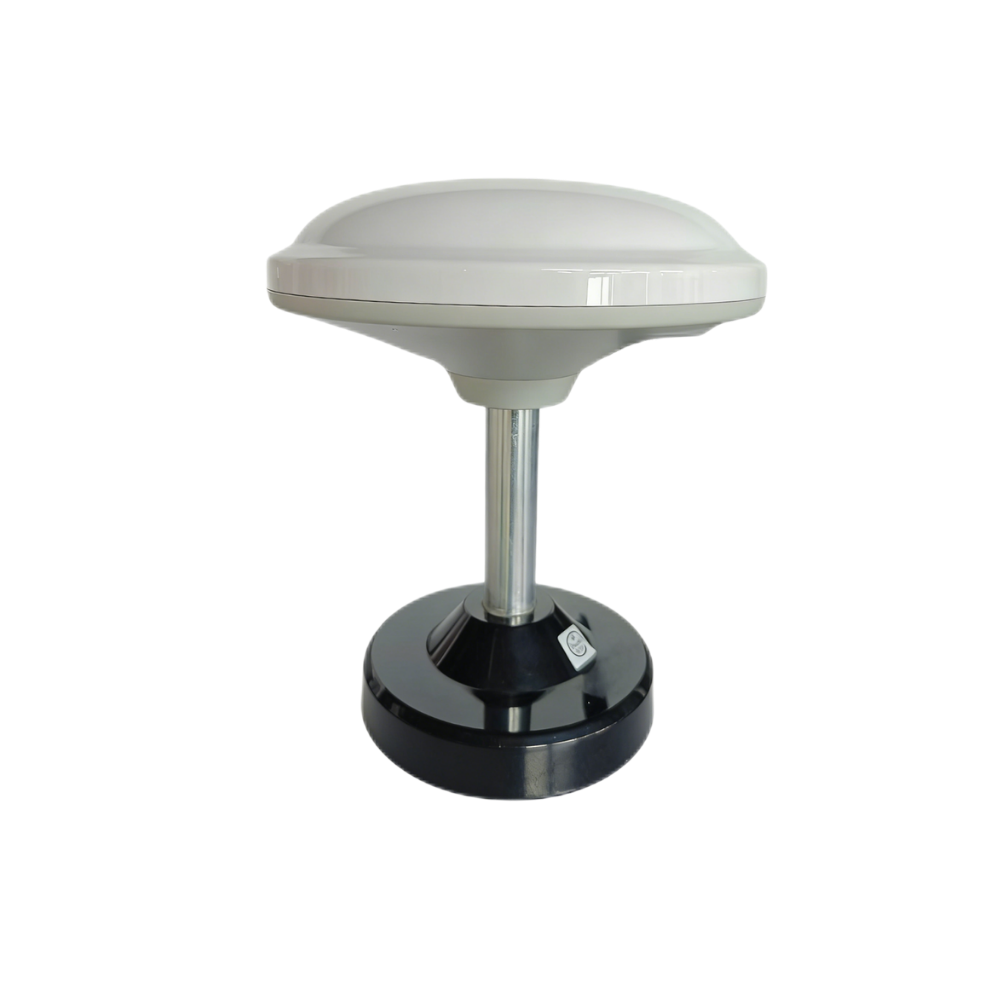
The Multiband RTK Survey Module HM-D13 is a complementary positioning module for applications that require precise outdoor location. It integrates multiband, multi-constellation satellite reception and supports professional RTK workflows.
| Specification | HM-D13 Real Specification |
|---|---|
| Frequency Band | GPS L1/L5, Beidou B1/B2A/B2I, Galileo E1/E5, QZSS L1/L5, GLONASS G1, IRNSS |
| RTK Position Accuracy | H: 1cm + 1ppm, V: 1.5cm + 1ppm |
| Protocol | NMEA 0183 output and RTCM input at rover side; RTCM output at base side |
| Baud Rate | 115200 bps |
| Dimensions | Φ152 × 67.9mm |
| Weight | <550g |
| Interface | TTL-level UART interface |
| Timing Synchronization Accuracy | 20ns |
| Operating Temperature | -40℃ to 85℃ |
| Other | Supports optional 4G radio module |
LiDAR Measures Depth, RTK Measures Position
Depth sensing and global positioning solve different problems. LiDAR tells the machine what is nearby. RTK tells the machine where it is outdoors. In survey, mapping, and UAV workflows, both types of data may be required to create useful results. A drone may use LiDAR for altitude awareness and obstacle detection while using RTK for accurate georeferenced flight and mapping.
It helps to separate the two jobs clearly. If the machine needs to avoid a wall, shelf, tree, vehicle, person, or terrain change, LiDAR is part of the answer. If the machine needs to know its outdoor position with centimeter-level accuracy, RTK is part of the answer. Many real systems need both.
HM-D13 for Centimeter-Level Positioning
HM-D13 supports GPS, Beidou, Galileo, QZSS, GLONASS, and IRNSS satellite signals. Its RTK positioning accuracy is specified as horizontal 1cm + 1ppm and vertical 1.5cm + 1ppm. With NMEA 0183 output, RTCM correction workflows, TTL-level UART interface, 115200 bps baud rate, 20ns timing synchronization accuracy, and -40℃ to 85℃ operating temperature, it is designed for outdoor systems that need stable positioning performance.
For outdoor robotics, survey platforms, UAV mapping, construction automation, and infrastructure inspection, that positioning layer can be just as important as the perception layer. A good system knows both what is around it and where it is operating.
View Product Details & Pricing ➔
How to Choose the Right Depth Sensor
The best sensor depends on the workflow, not the hype. iPhone LiDAR, dedicated depth cameras, industrial dToF modules, and RTK-assisted perception systems all have valid roles. The right choice depends on whether you need a convenient scan, a visual model, a repeatable measurement, an embedded perception stream, or a full outdoor navigation stack.
Use iPhone LiDAR If Convenience Matters Most
Use iPhone LiDAR if you need quick room scans, AR visualization, floor plans, rough site references, non-critical measurements, or simple scanning experiments. It is a strong tool when the operator is a person holding a phone and the output is used for planning, communication, or visual context.
✅ Good fits include room layout capture, furniture planning, real estate walkthroughs, AR placement, classroom demonstrations, renovation notes, and quick visual documentation. It is less ideal when the system must run continuously without a person, connect directly to a controller, or provide predictable sensor data for automated decision-making.
Use Industrial dToF LiDAR If Repeatability Matters
Use an industrial dToF LiDAR module if you need defined ranging capability, repeatable measurement, depth maps, point cloud data, embedded integration, UART/UDP/UVC interfaces, SDK support, Linux or ARM platform support, controlled power consumption, known weight, and predictable mounting.
⚙️ These parameters are essential for robot obstacle avoidance, UAV ranging, smart inspection, industrial monitoring, zone detection, autonomous navigation, and machine vision development. When the sensor becomes part of the machine instead of something a person holds, published specifications and open interfaces become much more important.
Add RTK Positioning for Outdoor Autonomy
Add RTK positioning if you are mapping outdoors, building a UAV survey system, developing an outdoor autonomous vehicle, or requiring centimeter-level global positioning. RTK does not replace LiDAR. Instead, it complements LiDAR by providing high-accuracy location data.
⚙️ In a complete outdoor robotics system, LiDAR, cameras, IMU, RTK GNSS, and SLAM software may all contribute to localization, mapping, obstacle avoidance, and navigation. The trick is not buying the most impressive sensor on paper. The trick is matching the sensor stack to the job.
| Application | iPhone LiDAR | HM-LD1 dToF LiDAR | HM-D13 RTK Module |
|---|---|---|---|
| Room scanning | Good | Possible if embedded depth data is needed | Not required |
| 3D printing small parts | Limited | Better for depth measurement, but may need higher-resolution scanning for fine geometry | Not required |
| Robot obstacle avoidance | Demo only | Recommended | Optional for outdoor localization |
| UAV altitude hold | Not practical | Recommended | Useful for outdoor navigation |
| Outdoor survey robot | Limited | Useful for perception | Recommended |
| SLAM development | Useful for experiments | Recommended for embedded integration | Useful for global correction outdoors |
| Industrial inspection | Limited | Recommended | Optional depending on positioning needs |
Conclusion
iPhone LiDAR is impressive, useful, and genuinely convenient. It is excellent for consumer spatial capture, AR placement, room scanning, quick measurement, floor plan generation, and visual reference. It helps more people experience depth sensing without specialized equipment, and that is valuable.
But look, it is not the best option for robotics deployment, industrial sensing, repeatable measurement, or embedded integration. When a project requires known range, defined accuracy, stable FOV, point cloud or depth map output, low power, compact mounting, SDK support, and open interfaces, a dedicated module is the more practical engineering path.
If your project requires embedded depth sensing, robotic perception, UAV obstacle avoidance, or repeatable industrial distance measurement, explore the DTOF Solid state LiDAR HM-LD1. For outdoor survey and centimeter-level positioning, see the Multiband RTK Survey Module HM-D13.
HM-LD1 dToF Solid-State LiDAR: Compact Depth Sensing for UAVs & Robotics
FAQ
Is iPhone LiDAR worth it for 3D scanning or 3D printing?
What do people actually use iPhone LiDAR for?
Has iPhone LiDAR improved enough to replace professional depth sensors?
Can iPhone LiDAR be used for robot navigation?
How accurate is iPhone LiDAR for measuring distance?
Is iPhone LiDAR better than photogrammetry?
What is the best alternative to iPhone LiDAR for robotics?
Do I need LiDAR, RTK, or both?
📚 References & Further Reading
- Industry Standard: Ouster
- Industry Standard: Innoviz Technologies
- Related Guide: What Does LiDAR Stand For?
- Related Guide: VIO, VINS, and VSLAM Troubleshooting Guide
- Product Reference: DTOF Solid state LiDAR HM-LD1
- Product Reference: Multiband RTK Survey Module HM-D13






