


USGS LiDAR News: Where to Find Updated 3DEP Data, Maps, and Robotics-Ready LiDAR Alternatives
Here’s the deal: USGS LiDAR news matters because 3DEP data is one of the most useful public sources for high-resolution elevation models, terrain mapping, flood modeling, infrastructure planning, forestry analysis, geospatial research, and engineering work in the United States. If you are trying to understand ground elevation, drainage behavior, slope risk, access roads, vegetation structure, or site constraints, USGS LiDAR can save a project team a lot of time. But finding the newest USGS LiDAR release is rarely as simple as searching for one national “latest LiDAR map.” Updates depend on regional acquisition projects, state and local partnerships, QA processing, funding cycles, coordinate systems, vertical datums, file formats, and publication timelines inside The National Map and related geospatial portals.
This guide walks through where to track updated USGS 3DEP LiDAR data, how to download free LiDAR point clouds and elevation products, what to check before using LAS, LAZ, DEM, DSM, DTM, or EPT datasets, and why public datasets may not be enough for robotics, UAVs, autonomous mobile robots, embedded vision, or real-time inspection projects. For teams that need live depth sensing instead of static terrain data, it also compares public geospatial LiDAR with compact dToF solid-state LiDAR modules such as the DTOF Solid State LiDAR HM-LD1, designed for onboard obstacle avoidance, SLAM support, altitude hold, presence detection, smart inspection, and embedded 3D sensing.
Table of Contents
- 👉 What “USGS LiDAR News” Really Means
- 👉 Where to Find Updated USGS LiDAR Data
- 👉 How 3DEP LiDAR Updates Work
- 👉 Where to Download Free US LiDAR Maps and Point Clouds
- 👉 Understanding LAS, LAZ, DEM, DSM, DTM, and EPT Formats
- 👉 Coordinate Systems, Datums, and Metadata Checks
- 👉 Common USGS LiDAR Problems and How to Solve Them
- 👉 Public LiDAR Data vs Real-Time Onboard LiDAR
- 👉 Robotics-Ready LiDAR Alternative: DTOF Solid State LiDAR HM-LD1
- 👉 Industrial Use Cases for USGS and Real-Time LiDAR
- 👉 Recommended Workflow for Engineers and GIS Teams
- 👉 FAQ: USGS LiDAR News, 3DEP Data, and Robotics-Ready LiDAR
What “USGS LiDAR News” Really Means
When people search for “usgs lidar news,” they are usually not looking for a press release. They are looking for something practical: a fresh data release, a new coverage announcement, a download portal, or a straight answer on whether their county, watershed, city, jobsite, or project corridor has updated elevation data. In practice, USGS LiDAR news usually means updates tied to the 3D Elevation Program, commonly known as 3DEP. Those updates may include new airborne LiDAR collections, public availability of point clouds, improved elevation products, revised metadata, or acquisition status information for a specific region.
Look, USGS LiDAR news does not always show up as one clean national headline. A dataset may be acquired by a contractor, processed by a partner, documented by a state agency, and later published through a national or local portal. That creates a discovery problem for GIS teams and engineers. A search result may point you to The National Map, a state GIS clearinghouse, a county open data hub, OpenTopography, NOAA Digital Coast, or a 3DEP acquisition status page. Each source may answer a different part of the same question: whether data exists, whether it is downloadable, whether it is current enough, and whether it is technically suitable for the job.
USGS LiDAR news also matters outside traditional GIS work. Civil engineers use it for floodplain modeling, transportation planning, drainage design, slope analysis, and infrastructure risk assessment. Forestry teams use it to evaluate canopy structure and terrain. Geologists use it for landslide and fault mapping. Smart city teams use elevation products for planning and asset management. Robotics and UAV teams may use public elevation data for broad terrain context, simulation, or mission planning. But there is one key point that gets missed all the time: public LiDAR is historical geospatial data, not a live perception feed. That distinction becomes critical when a system needs to react to moving people, vehicles, pallets, drones, terrain changes, temporary barricades, or fresh hazards.
At the sensing level, LiDAR systems often rely on optical measurement principles, including time-of-flight measurement, where distance is estimated from light travel behavior. For readers researching optical sensing fundamentals, the IEEE Photonics Society is a useful authority resource for photonics-related engineering context. Still, public 3DEP datasets and embedded LiDAR modules serve very different operational roles. One provides mapped terrain and elevation products; the other provides live spatial perception for machines operating in dynamic environments.
Where to Find Updated USGS LiDAR Data
The first practical step is understanding that updated USGS LiDAR data may appear in more than one place. The National Map Downloader is usually the starting point for USGS elevation products and 3DEP point cloud discovery. Users can search by address, county, state, bounding box, or map extent, then select elevation data layers and check whether point clouds, DEMs, or related products are available. Before downloading, review the metadata, confirm the coordinate reference system, identify the vertical datum, and understand the acquisition date. In the shop, that kind of upfront checking prevents hours of rework later.
3DEP data and acquisition status resources help users determine whether an area has planned, in-progress, completed, or published coverage. That distinction matters because “acquired” does not always mean “download-ready.” LiDAR acquisition can happen months before classified point clouds and derived elevation products become available. A project may still be going through classification, hydro-flattening, quality review, tile packaging, or metadata preparation. If you are working under a project deadline, do not assume that a flown dataset is immediately usable.
State GIS portals and local government data hubs are often essential. Many state agencies publish LiDAR data earlier than national systems, sometimes with better local documentation, county-level acquisition dates, state plane coordinate systems, contours, breaklines, hydro-flattened DEMs, or tile indexes. Local portals may also include contractor reports, accuracy statements, and project boundary files that are not easy to locate from a national interface. If a dataset seems missing from a USGS download tool, checking state and county sources can save a lot of frustration.
OpenTopography is another valuable source for research-grade LiDAR and terrain processing workflows. It is especially helpful for users who need previewing, subsetting, and scientific access to point cloud or derived elevation products. NOAA Digital Coast is particularly useful for coastal LiDAR, shoreline analysis, floodplain studies, wetland mapping, storm surge planning, and resilience projects. Coastal datasets may use different collection strategies and vertical datum conventions, so metadata review is especially important before combining them with inland 3DEP products.
For teams moving from public terrain analysis to real-time machine perception, updated public datasets are only one part of the workflow. A robot, UAV, smart camera, or industrial inspection system cannot rely on a static public point cloud to detect a moving forklift, pedestrian, temporary barrier, or changed storage layout. In that case, teams should evaluate onboard sensing options such as the DTOF Solid State LiDAR HM-LD1, which is designed for embedded depth sensing and real-time ranging applications.
How 3DEP LiDAR Updates Work
3DEP LiDAR updates are regional rather than instant national updates. Data acquisition is typically organized around project areas, counties, watersheds, states, or partner-defined regions. Flight timing may depend on weather windows, leaf-off requirements, snow cover, vegetation conditions, aircraft availability, terrain complexity, airspace restrictions, local priorities, and budget cycles. A region with strong partner funding may receive updated coverage earlier than a region where acquisition has not yet been funded.
Funding and partnerships shape many 3DEP timelines. Federal agencies, state governments, local governments, tribal organizations, academic institutions, utilities, and private stakeholders may share costs and define common data requirements. These partnerships help improve national elevation coverage, but they also mean update schedules are not uniform. A county-level transportation corridor, a flood-prone watershed, or a high-priority wildfire area may be updated sooner than surrounding regions because there is a stronger immediate use case or funding path.
After acquisition, professional LiDAR data requires serious processing. Raw returns must be calibrated, cleaned, classified, tiled, and documented. Classification may identify ground, vegetation, buildings, water, noise, overlap points, and other categories depending on project specifications. Elevation products may require additional work such as bare-earth modeling, hydro-flattening, breakline integration, raster generation, and quality assurance. That is why public LiDAR releases often lag behind flight dates. A dataset can be technically collected but not yet ready for engineering-grade use.
Publication adds another layer of delay. A project may appear in an acquisition status resource before the final LAZ tiles, DEM products, and metadata packages are easy to download. Treat publication as a pipeline rather than a single event. The most reliable workflow is to track national sources, state sources, and local sources together, then document the exact dataset version used in analysis. This is especially important for regulated engineering work, flood studies, infrastructure assessment, or any project where acquisition date and vertical accuracy affect decisions.
Where to Download Free US LiDAR Maps and Point Clouds
Free US LiDAR data is available from several public sources, but each source is better suited to different workflows. A national download portal may be ideal for broad discovery, while a state GIS site may provide richer local documentation. A research platform may make subsetting easier, while a coastal platform may provide the best data for shoreline and flood resilience work. The table below summarizes common options.
| Source | Best For | Common Data Types | Notes |
|---|---|---|---|
| USGS The National Map Downloader | 3DEP elevation products and national coverage discovery | LAS, LAZ, DEM, metadata packages | Primary starting point for USGS elevation data |
| 3DEP Resources | Coverage status, acquisition planning, elevation program context | Status maps, project information, elevation products | Useful for understanding whether data is planned or published |
| State GIS Portals | Local and state-specific LiDAR releases | LAZ, LAS, DEM, contours, breaklines | May include earlier releases or richer local metadata |
| OpenTopography | Research workflows and point cloud processing | Point clouds, DEMs, derived terrain products | Helpful for subsetting and scientific access |
| NOAA Digital Coast | Coastal terrain, shoreline, flood, and resilience projects | Coastal LiDAR, DEMs, shoreline-related datasets | Check vertical datums carefully |
To download without wasting hours, start with a small area of interest rather than a full county or large watershed. Confirm the tile index before downloading, read the metadata first, and verify the coordinate reference system and vertical datum. Check the acquisition date, point density, classification scheme, accuracy statement, file format, and units. If storage or transfer speed matters, LAZ is usually more efficient than LAS because it compresses point cloud data while preserving essential information.
Software choice depends on the workflow. QGIS can help with visualization and GIS integration. CloudCompare is useful for point cloud inspection and manual analysis. ArcGIS Pro is common in enterprise GIS environments. PDAL is strong for automated processing, clipping, reprojection, filtering, and pipeline-based workflows. LAStools is widely used for practical point cloud conversion and processing. For large datasets, streaming formats and cloud-hosted workflows can reduce the need to download everything before evaluating coverage and quality.
Understanding LAS, LAZ, DEM, DSM, DTM, and EPT Formats
LAS is a widely used binary file format for LiDAR point cloud data. It can store x, y, and z coordinates, intensity, return number, classification, GPS time, scan angle, and sometimes color attributes. LAZ is a compressed version of LAS that reduces file size significantly while preserving point cloud information. For public LiDAR datasets, LAZ is often the most practical format because county-scale data can be extremely large. Many modern GIS and point cloud tools can read LAZ directly, though some workflows may still require conversion to LAS.
DEM, DSM, and DTM products represent elevation in raster or gridded form, but they are not interchangeable in every workflow. A DEM is a general digital elevation model and may be used broadly depending on the source definition. A DTM usually refers to a bare-earth terrain model, where vegetation and structures have been removed to represent ground elevation. A DSM represents the surface, including trees, buildings, and other above-ground features. Because agencies and tools may use terms differently, metadata is the authority. Do not assume a “DEM” is bare earth unless the documentation says so.
EPT, or Entwine Point Tile, is useful for streaming massive point clouds. Instead of downloading an entire dataset before viewing or processing, users can access hierarchical point cloud tiles over the network. This is valuable when dealing with large regional datasets, exploratory analysis, or browser-based visualization. EPT does not replace LAS or LAZ in every workflow, but it can make discovery and previewing much more efficient.
Raster elevation is often enough for flood modeling, slope analysis, drainage planning, terrain visualization, and broad elevation studies. Point clouds matter when users need classification, object extraction, vegetation structure, buildings, clearance analysis, bridge context, corridor analysis, or custom surface generation. The right format depends on the question. If the task is “what is the ground elevation here,” a DEM may be enough. If the task is “which points are vegetation, structure, ground, and overhead obstruction,” point cloud data is usually required.
Coordinate Systems, Datums, and Metadata Checks
Many LiDAR problems that look like bad data are actually coordinate system or datum problems. A point cloud may appear shifted, vertically wrong, rotated, or misaligned with other layers because the software is applying the wrong coordinate reference system, units, transformation, vertical datum, or geoid model. This is why metadata review should happen before processing, not after a problem appears in the map.
Horizontal coordinate systems may include geographic coordinates, UTM zones, State Plane systems, local projected systems, or other coordinate frameworks. Engineering teams should be careful when mixing projected and geographic coordinates. A layer in latitude and longitude may not align correctly with a projected point cloud unless the software correctly recognizes and transforms both systems. Even when the horizontal position looks close, the units can still cause problems if feet and meters are mixed.
Vertical datums are equally important. Elevation data may reference NAVD88, ellipsoid heights, or another vertical framework. Geoid models may be needed to convert between ellipsoid heights and orthometric heights. A vertical mismatch can affect flood modeling, bridge clearance, UAV mission planning, drainage analysis, construction validation, and infrastructure measurements. In coastal environments, vertical datums can be even more complex because tidal datums and coastal modeling requirements may apply.
The best rule is simple: metadata first. Before downloading large datasets or building a processing pipeline, verify projection, datum, units, acquisition date, collection method, point density, classification scheme, vertical accuracy, horizontal accuracy, quality level, tile naming convention, and any special processing notes. For professional work, document the dataset source, version, acquisition date, and transformations used. That documentation keeps the whole team aligned when results are reviewed, shared, or reproduced later.
Common USGS LiDAR Problems and How to Solve Them
One common problem is that an area appears to have no LiDAR coverage. This can happen because the region has not been acquired, funding has not been allocated, the project is still in processing, the data is not yet published, or the dataset is available only through a state or local portal. The solution is to search in layers: start with national sources, then check 3DEP status information, state GIS portals, county hubs, and specialized sources such as OpenTopography or NOAA Digital Coast.
Another common problem is dataset size. Public LiDAR files can be huge, especially when downloading point clouds for a large region. Instead of downloading everything, clip to the area of interest, use tile indexes, choose LAZ when possible, stream EPT data when available, and process a small sample first. Automated tools such as PDAL can help filter, reproject, merge, or convert point cloud data without requiring manual work for every tile.
Coordinate confusion is also frequent. If the point cloud does not align with imagery, parcels, contours, or engineering layers, review the coordinate system and vertical datum before assuming the data is wrong. Confirm EPSG codes, projection units, State Plane zone, UTM zone, vertical datum, and geoid model. If multiple data sources are involved, document every transformation. This is especially important when combining federal, state, local, and contractor-produced datasets.
Data age can be a serious limitation. Roads, bridges, warehouses, industrial yards, mines, quarries, shorelines, construction sites, forests, and floodplains can change faster than public datasets update. For planning and historical analysis, older public LiDAR may still be valuable. For operational systems, it may be insufficient. A UAV inspecting a bridge or an AMR navigating a warehouse needs to measure the current scene, not a static dataset collected years ago.
The final major problem is real-time sensing. USGS LiDAR is mapping data, not a live sensor. It cannot detect a moving vehicle, person, forklift, temporary cone, pallet, landing hazard, changed shelf, or newly excavated terrain. When the project requires live obstacle detection, distance measurement, or machine perception, onboard sensors are required. Public LiDAR can provide macro context, but real-time LiDAR provides local perception.
Public LiDAR Data vs Real-Time Onboard LiDAR
Public LiDAR data and real-time onboard LiDAR are often confused because both use the word LiDAR, but they solve different problems. USGS LiDAR is geospatial mapping data. It is typically historical, georeferenced, processed, classified, and distributed as point clouds or derived elevation products. It is excellent for terrain analysis, hydrology, forestry, infrastructure planning, elevation modeling, and broad environmental context.
Real-time onboard LiDAR is a perception sensor. It measures the environment as a robot, UAV, camera, or embedded system operates. Robotics LiDAR supports obstacle detection, navigation, localization, SLAM, altitude hold, presence detection, terrain following, drop-off detection, and autonomous decision-making. Unlike a public dataset, a live sensor can detect changes in the operating environment. That difference is critical for safety and autonomy.
The best engineering workflows often use both. A UAV team may use USGS 3DEP data for mission planning and broad terrain awareness, then use onboard LiDAR for real-time altitude hold and obstacle detection during flight. A civil infrastructure team may use public DEMs for watershed and access planning, then use live sensing on a drone or robot for close-range inspection. A smart city team may use public elevation data for planning and deploy real-time LiDAR for intrusion monitoring, people detection, or traffic-adjacent sensing.
Robotics LiDAR modules often use direct or indirect time-of-flight measurement principles to estimate distance from emitted light pulses or modulated signals. For readers researching optical sensing fundamentals, the IEEE Photonics Society provides valuable technical context around photonics and sensing. In practical industrial design, the choice is not “public data or onboard sensor.” The better question is which layer of perception the system needs: historical terrain context, live local depth, or both.
Robotics-Ready LiDAR Alternative: DTOF Solid State LiDAR HM-LD1
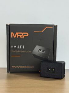
For applications where public 3DEP data is too old, too coarse for live navigation, unavailable in the project area, or unsuitable for embedded perception, a compact onboard LiDAR module can provide real-time depth data directly on the robot, UAV, camera, or industrial inspection system. The DTOF Solid State LiDAR HM-LD1 is a compact SPAD dToF-based module designed for robotics, UAV altitude hold, terrain following, obstacle avoidance, SLAM support, object recognition, presence detection, volume measurement, and zone intrusion monitoring.
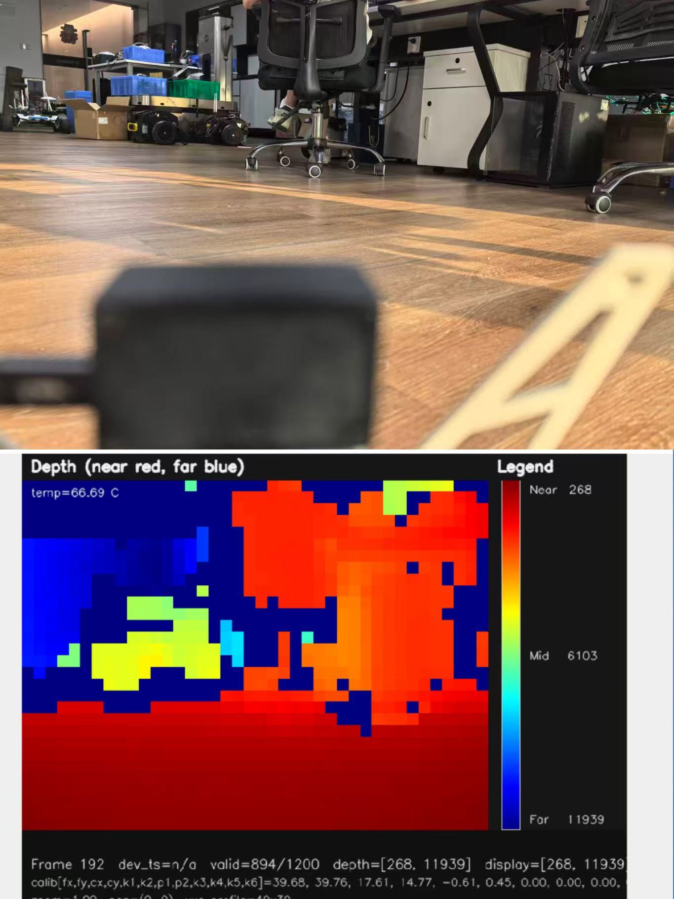
The HM-LD1 is positioned for teams that need embedded 3D sensing rather than static map layers. It delivers real-time depth images and 3D point cloud data for environmental perception. It supports indoor or nighttime ranging up to 25 m and outdoor daytime ranging up to 8 m, making it relevant for autonomous navigation, smart inspection, robotic vision development, and sensing in spaces where the environment can change between missions. With UVC, UDP, and UART interfaces, it can be integrated with PCs, Raspberry Pi platforms, flight controllers, and embedded Linux systems for both prototyping and deployment.
| Specification | DTOF Solid State LiDAR HM-LD1 |
|---|---|
| Product Name | DTOF Solid State LiDAR HM-LD1 |
| LiDAR Technology | SPAD dToF solid-state LiDAR |
| Dimensions | 43.5 mm × 30 mm × 26.5 mm |
| Ranging Capability | Indoor: 0.5–25 m; Outdoor: 0.2–8 m |
| Ranging Accuracy | ±3 cm |
| Field of View | 60° horizontal × 45° vertical |
| Resolution | 40 × 30 |
| Frame Rate | 10 fps |
| Interfaces | UART / UDP / UVC |
| Operating Temperature | -20 ℃ to 60 ℃ |
| Power Consumption | 1.2 W |
| Weight | 28 g |
| Supported Development Platforms | x86 Windows, x86 Linux, ARM Linux SDK support |
| Typical Applications | Obstacle avoidance, SLAM support, UAV altitude hold, terrain following, autonomous navigation, smart inspection, user presence detection, object recognition, volume measurement, zone intrusion monitoring |
| Product Page | View DTOF Solid State LiDAR HM-LD1 |
| Brochure | Download DTOF SSL HM-LD1 Product Brochure |
View Product Details & Pricing ➔
Compact dToF LiDAR matters because many robotic and UAV systems have strict space, weight, and power constraints. The HM-LD1 weighs 28 g and consumes 1.2 W, making it suitable for platforms where sensor size affects mechanical integration and flight or runtime. Its field of view of 60° horizontal by 45° vertical enables depth perception across a useful scene area rather than a single narrow distance point. Its 40 × 30 resolution and 10 fps frame rate support real-time depth map use cases where a system needs repeated spatial updates.
The module’s interface options support different engineering architectures. UART is useful for embedded controllers and compact systems. UDP can support networked perception or Linux-based robotics systems. UVC can simplify camera-like integration with PC or embedded vision workflows. MRP offers SDKs for x86 Windows, x86 Linux, and ARM Linux, allowing development across common robotics, prototyping, and embedded deployment environments.
Best-fit applications include UAV altitude hold, terrain following, obstacle avoidance, AMR navigation, smart inspection, cameras, security systems, object recognition, volume measurement, user presence detection, and zone intrusion monitoring. Outdoor performance depends on illumination, target reflectivity, surface angle, and environmental conditions, so engineers should validate performance in the intended environment. Still, for projects where public LiDAR data cannot provide live perception, a compact onboard dToF module can fill the gap between mapped terrain and real-time machine awareness.
Industrial Use Cases for USGS and Real-Time LiDAR
Civil infrastructure and bridge inspection workflows often benefit from both public and onboard LiDAR. USGS 3DEP data can help with terrain context, access planning, drainage analysis, flood risk, slope assessment, and surrounding landform evaluation. Real-time LiDAR on a UAV or robot can support close-range obstacle detection, positioning assistance, underside inspection, and safe approach planning. Public data provides the macro environment; onboard LiDAR supports local operational awareness.
UAV terrain following is another strong example. Public DEMs can help plan a mission path and estimate terrain variation before flight. But terrain changes, and a UAV may encounter vegetation, structures, wires, vehicles, or unexpected obstacles that are not represented in historical elevation data. A lightweight onboard LiDAR module can provide real-time distance information for altitude hold, landing support, terrain following, and obstacle avoidance.
Autonomous mobile robots and warehouses usually do not rely on USGS data because indoor environments are outside the scope of national terrain mapping. However, robotics developers searching for LiDAR through mapping topics often discover the difference between geospatial datasets and live perception sensors. For AMRs, current obstacle detection is essential. Shelves move, pallets appear, people walk through aisles, forklifts cross paths, and temporary barriers change the environment. Live sensing is not optional in those use cases.
Mining, quarries, construction sites, and industrial yards change frequently. Public LiDAR may provide a useful baseline, but terrain and stockpiles can change daily or weekly. Onboard LiDAR can support mobile equipment, UAV inspection, local mapping, collision avoidance, and zone monitoring. Smart city and security systems can also combine planning-grade elevation layers with real-time LiDAR for intrusion detection, people detection, vehicle presence, and access monitoring.
Recommended Workflow for Engineers and GIS Teams
The first step is to define whether the project needs static elevation data, live sensing, or both. If the goal is flood modeling, terrain slope, drainage context, route planning, or historical landscape analysis, USGS 3DEP and related public datasets may be appropriate. If the goal is obstacle avoidance, UAV altitude hold, robot navigation, user presence detection, or live inspection, onboard sensing is required. If the project combines planning and autonomy, both public datasets and live sensors may be needed.
The second step is to search public sources systematically. Start with The National Map and 3DEP resources, then check state GIS portals, county hubs, OpenTopography, and NOAA Digital Coast where relevant. Do not stop after one failed search. Public LiDAR availability is distributed, and a dataset may be easier to find from a local portal than a national interface.
The third step is to validate metadata before processing. Confirm coordinate reference system, vertical datum, units, acquisition date, point density, classification scheme, vertical accuracy, horizontal accuracy, quality level, and file format. Then process a small test area before committing to large downloads or full pipeline development. This reduces wasted time and helps reveal coordinate, format, or data quality issues early.
The final step is to add real-time LiDAR when the environment must be measured live. Public LiDAR can inform planning, but it cannot provide current obstacle data. For embedded systems, evaluate range, accuracy, field of view, resolution, frame rate, interface, SDK support, operating temperature, power consumption, size, and weight. Compact modules such as HM-LD1 are designed for teams that need practical depth sensing inside robotics, UAV, smart camera, inspection, and security applications.
FAQ: USGS LiDAR News, 3DEP Data, and Robotics-Ready LiDAR
When will USGS release updated LiDAR data?
Where can I download free US LiDAR maps and point clouds?
Why is USGS LiDAR data missing, hard to use, or in the wrong coordinate system?
Is USGS LiDAR real-time data?
What is 3DEP LiDAR?
What is the difference between LAS and LAZ LiDAR files?
Can USGS LiDAR data be used for robots?
What type of LiDAR is useful for UAV altitude hold and terrain following?
Why use dToF LiDAR instead of only a camera?
📚 References & Further Reading
- Industry Standard: IEEE Photonics Society and time-of-flight measurement
- Related Guide: DTOF Solid State LiDAR HM-LD1






