In the world of geospatial engineering, surveying, and precision agriculture, accuracy isn’t just a goal—it’s a make-or-break factor for project success. For decades, professionals relied on conventional GPS systems to gather location data, but these tools often fell short when it came to centimeter-level precision. Today, RTK (Real-Time Kinematic) technology has emerged as a game-changer, redefining what’s possible in fieldwork and data collection.
What Exactly Is RTK Technology, and How Does It Work?
To understand RTK, it’s essential to start with its foundation: GPS and satellite positioning. Traditional GPS receivers calculate location by measuring signals from multiple satellites, but they are prone to errors caused by atmospheric interference, satellite clock drift, and signal reflection. These errors can range from meters to tens of meters—far too imprecise for tasks like land surveying, construction layout, or precision farming.
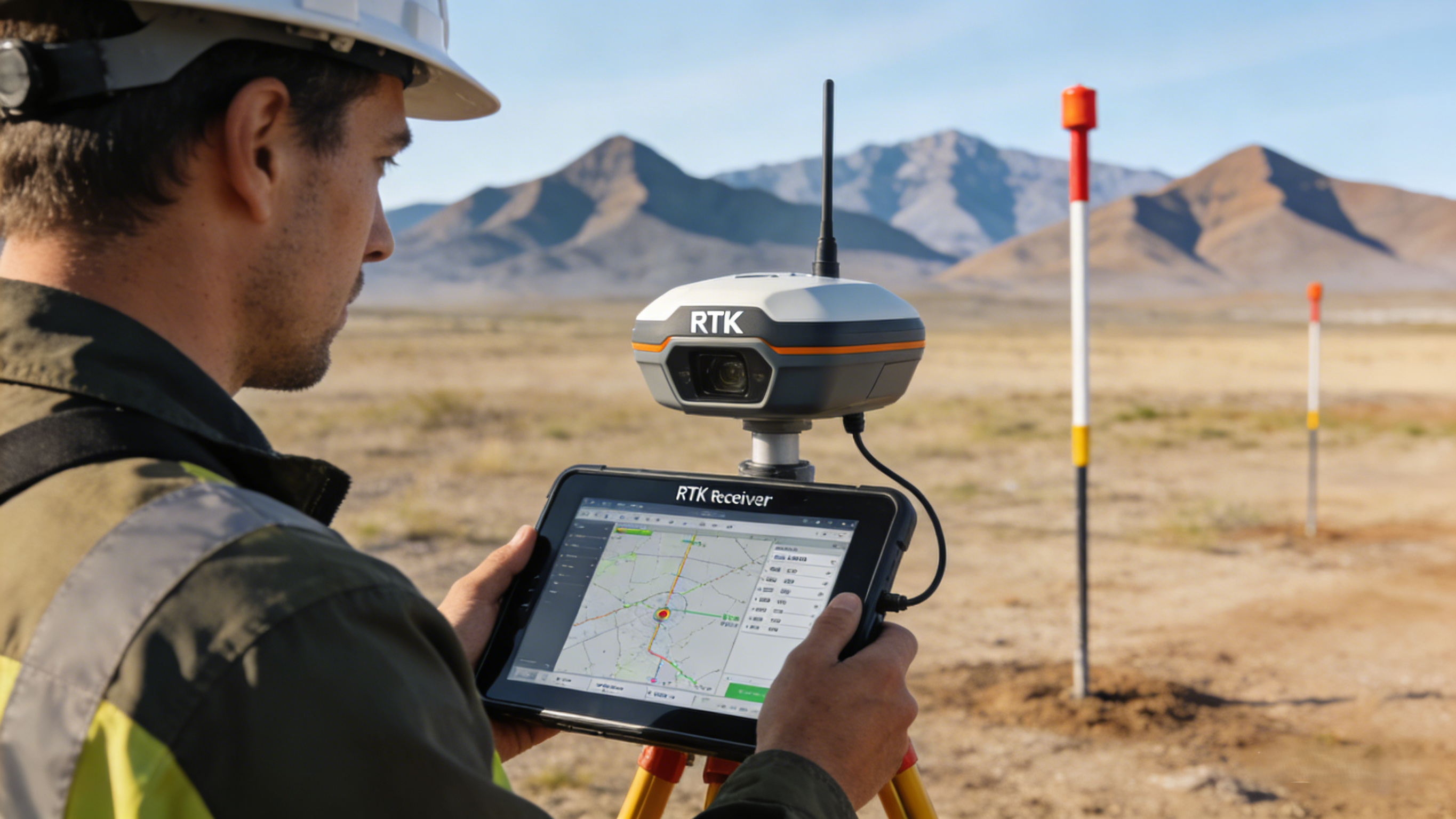
This technology solves this problem by adding a critical layer of real-time correction data. A typical RTK system consists of two components: a base station and a rover receiver. The base station is placed at a precisely known location, where it continuously tracks satellite signals and calculates the difference between its known position and the position derived from the satellite data. This difference—known as a correction message—is then transmitted to the rover receiver in real time, usually via a radio signal or cellular network.
The rover receiver uses this correction data to adjust its own satellite measurements, eliminating most of the errors that plague standard GPS. The result? Positioning accuracy of 1–2 centimeters horizontally and 2–3 centimeters vertically—an unprecedented level of precision that has transformed entire industries. Unlike static surveying methods that require post-processing data after fieldwork, this technology provides instant, verified coordinates, allowing field teams to make decisions on the spot and avoid costly rework.
RTK vs. Traditional Positioning Tools: A Clear Advantage
When pitted against traditional GPS and manual surveying tools, RTK stands out for three key reasons: speed, accuracy, and efficiency. Let’s break down the differences:
First, this technology cuts down fieldwork time dramatically. Traditional surveying often requires setting up multiple control points and taking repeated measurements to reduce errors—a process that can take days for large sites. With RTK, the rover receiver delivers accurate data in seconds, so surveyors can cover more ground in less time. For example, a team tasked with mapping a 50-acre construction site might finish the job in a single day with this technology, compared to three days with conventional methods.
Second, this technology eliminates the guesswork that comes with traditional tools. Manual surveying relies on optical instruments like theodolites and total stations, which are vulnerable to human error and weather conditions. Even advanced GPS systems without RTK correction can’t match the consistency of this technology data, especially in challenging environments like dense forests or urban canyons where satellite signals are weak.
Third, this technology integrates seamlessly with modern technology. Most RTK receivers sync with smartphones, tablets, and GIS (Geographic Information System) software, allowing users to visualize data in real time, create digital maps, and share results instantly with off-site teams. This level of connectivity is a far cry from the paper-based logs and post-processing delays of traditional surveying.
Key Applications of RTK Technology Across Industries
The versatility of RTK has made it indispensable across a wide range of sectors, from construction to agriculture to drone mapping. Here are some of the most impactful uses:
In construction, this technology is used for site layout, ensuring that buildings, roads, and utility lines are placed exactly where they’re designed to be. This precision reduces material waste and prevents costly mistakes, such as digging foundations in the wrong location. For road construction, RTK-enabled machines can grade and pave surfaces with millimeter-level accuracy, resulting in smoother, longer-lasting roads.
In precision agriculture, this technology powers self-driving tractors, planters, and harvesters. Farmers use this technology to map their fields, identify variations in soil quality, and apply fertilizers and pesticides only where needed. This targeted approach reduces input costs, minimizes environmental impact, and boosts crop yields. Without RTK, precision agriculture would be little more than a concept—satellite guidance without real-time correction simply isn’t reliable enough for farm machinery.
In drone mapping, RTK-equipped drones capture high-resolution aerial images with geotagged coordinates that are accurate to the centimeter. This is critical for applications like disaster response, where first responders need precise maps of affected areas, and environmental monitoring, where scientists track changes in land use over time. Unlike drones without this technology, which produce maps with meter-level errors, RTK drones deliver data that can be trusted for legal and regulatory purposes.
Overcoming Common Myths About RTK Technology
Despite its many benefits, this technology is often misunderstood. One common myth is that RTK is too expensive for small businesses. While high-end RTK systems can be costly, there are now affordable, entry-level options that offer the same core accuracy as premium models. For many users, the time and cost savings from RTK far outweigh the initial investment.
Another myth is that this technology doesn’t work in remote areas. While RTK does require a connection between the base station and rover, many systems now use cellular networks or satellite modems to transmit correction data, even in areas with no cell service. Some systems even allow users to set up a portable base station in the field, making this technology accessible anywhere.
Final Thoughts: Why RTK Is the Future of Precision Positioning
As industries continue to demand higher accuracy and efficiency, RTK technology will only become more important. Its ability to deliver real-time, centimeter-level positioning has transformed surveying, construction, and agriculture, turning once time-consuming tasks into quick, reliable processes. Whether you’re a small-scale farmer, a construction manager, or a drone operator, RTK offers a clear path to better results.